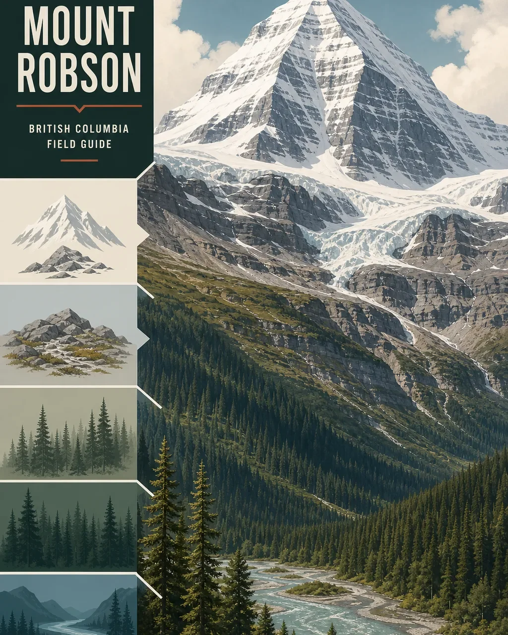
Mount Robson field guide: cedar-hemlock valleys, alpine tundra, and Berg Lake
A practical Mount Robson field guide tracing the climb from Fraser River valley forest through spruce and fir to alpine tundra, with named plant cues, wildlife timing, Berg Lake logistics, and a clear boundary between backcountry hiking and technical summit climbing.
The quick read
Mount Robson rises from the Fraser River valley to 3,954 m (12,972 ft), a vertical change of roughly 3,150 m across the park. BC Parks describes it as the highest peak in the Canadian Rockies. The ecological sequence is just as useful as the summit number: cedar-hemlock forest in the valley, spruce and fir higher up, then alpine tundra and rock. 12
The practical split is clear. The Berg Lake Trail is a multi-day backcountry route with campsites, water-treatment requirements, no cell service, and hazards that include cliffs, slippery rock, fast water, and waterfalls. Mount Robson's summit is a separate category: BC Parks recommends it for highly experienced climbers only because of sudden weather, heavy snow, avalanche, icefall, and rockfall exposure. 13
| Field note | Practical read |
|---|---|
| Summit | 3,954 m / 12,972 ft, using the BC Parks figure. The provincial names record also preserves older survey values, including 13,068 ft. <MarkdownCitation index="1" title="Mount Robson Park |
| Elevation story | From the Fraser River valley at about 800 m through forest, spruce-fir slopes, and alpine tundra to the summit. <MarkdownCitation index="1" title="Mount Robson Park |
| Best hiking window | Summer into early fall is the practical planning window for high-country hiking. Check current advisories, especially after storms and before winter travel. <MarkdownCitation index="1" title="Mount Robson Park |
| Berg Lake rating | Strenuous backcountry hiking. The route is suitable for beginners and experienced hikers in BC Parks' description, but its remoteness, length, hazards, and camping logistics demand real preparation. <MarkdownCitation index="3" title="Berg Lake Trail |
| Summit rating | Technical mountaineering for highly experienced climbers only. There is no useful trail-hike equivalence here. <MarkdownCitation index="1" title="Mount Robson Park |
The elevation cross-section
The exact boundary between vegetation zones changes with slope, aspect, snowpack, and drainage. A useful field reading is the broad sequence BC Parks gives for the park rather than a set of false precision lines on a map.
Valley floor, around 800 m. The lower Fraser River corridor is the warmest and most sheltered part of the profile. Cedar-hemlock forest and wet corridors frame the first stage of the climb, while roads, campgrounds, and short walks make this the most accessible part of the park. 1
Spruce and fir slopes. As the route gains height, the forest shifts toward spruce and fir. This is the long middle band of the field guide: cooler, darker, and increasingly shaped by snow, avalanche paths, and steep valley walls. The Berg Lake route moves through this forest before opening toward the lake and the higher passes. 13
Alpine tundra and rock. Above the forest, trees give way to low tundra plants, exposed ground, snow, and glacial terrain. This is where the mountain stops behaving like a long forest hike and starts behaving like a high alpine objective. The summit hazards listed by BC Parks belong to this upper world, not to a standard valley walk. 1
Plants to look for
- Cedar and hemlock: The valley-bottom forest is the first recognizable plant community on the elevation profile. Look for the change in canopy and moisture before trying to identify every species. 1
- Spruce and fir: These trees dominate the park's middle elevation description and form the main forest context for longer approaches. 1
- Labrador tea: BC Parks maintains a self-guided Labrador Tea Trail in the park, a useful reminder that the field guide is not only about summit plants. 1
- Alpine aster, monkey flower, and fireweed: A Mount Robson Valley visitor guide names these among the flowers that appear in spring and summer meadows. Treat them as seasonal meadow cues, not as a guarantee for every trail or date. 4
- Low alpine tundra plants: Near the upper passes, the important visual change is scale. Plants stay close to the ground and exposed rock occupies more of the route. Stay on designated trails because BC Parks identifies fragile terrain and erosion as reasons to avoid shortcuts. 3
Wildlife cues
Mount Robson Park records 42 mammal species, 182 bird species, four amphibians, and one reptile. The most useful way to read that list is by habitat. Deer, moose, elk, black bears, wolves, coyotes, and waterfowl belong mostly to the lower forest, river, and meadow story. Higher country can bring mountain goats, mountain sheep, caribou, and grizzly bears. 1
The wildlife rules matter as much as the sightings. Spring calving makes female moose, elk, and deer protective of young. In September and October, males can become more aggressive during the rut. Keep distance, keep food secured, and do not treat a quiet trail as an empty one. 1
The surrounding valley guide also lists eagles, hawks, warblers, and ptarmigan among its birdwatching possibilities. Those observations are best treated as regional cues, while the park's own species counts define the broader habitat picture. 41
Best season and route choice
For ordinary hiking, plan around summer and early fall, then confirm the current advisory before leaving. BC Parks notes that severe weather and trail closures have been common in recent years, and that the Berg Lake Trail can be used in winter only with appropriate preparation for dangerous conditions. Snowbird Pass is closed annually from May 1 through July 1 to protect wildlife during calving, which also makes the post-July-1 period a more sensible starting point for trips that include that area. 3
Choose the Berg Lake Trail if you want the mountain's ecological story without turning the trip into a summit climb. The route begins near the Welcome Centre, reaches Kinney Lake, continues toward Robson Pass, and supports multi-day camping. Cycling is allowed only on the first 7 km, to Kinney Lake; beyond that, the route is foot travel. During peak season, overnight campground reservations are required. 3
Prepare for a route with slippery rocks, cliffs, uneven surfaces, fast-flowing rivers, waterfalls, wildlife, and no cell service. Water from the trail must be boiled, filtered, or otherwise treated, and fires are prohibited along the route. These are not minor packing notes. They are the difference between a scenic backcountry trip and an underprepared one. 3
Choose the summit only if you already have the skills and equipment for technical alpine climbing. BC Parks lists sudden weather changes, heavy snowfall, avalanches, icefall, and rockfall among the hazards. A clear view from Berg Lake does not make the summit a hiking extension. 1
Trail decision
Mount Robson works as a field guide because the ecological and practical decisions line up. The valley offers accessible forest and short walks. The Berg Lake route delivers a serious multi-day approach through changing vegetation and wildlife habitat. The summit belongs to experienced mountaineers. Choose the trip by the upper limit of your preparation, not by how close the peak looks from the highway.
相似内容
- 登录后可发表评论。
More from this channel
- Mount Rogers field guide: alpine balds, spruce-fir forest, and Virginia's high point
- Humphreys Peak field guide: ponderosa pine, bristlecone, and alpine tundra
- Wheeler Peak field guide: alpine tundra, spruce-fir forest, and Williams Lake
- Pikes Peak field guide: ponderosa pine, alpine tundra, and Barr Trail
- Mount Shasta field guide: red fir, alpine meadows, and Avalanche Gulch
- Mount Baker field guide: old-growth forest, subalpine meadows, and glacial summit
- Mount Elbert Field Guide: Lodgepole Forest, Alpine Tundra, and Colorado's High Point
- Mount Marcy field guide: hardwood forests, boreal spruce-fir, and fragile alpine rock