Misti: 12 kilometres from a million people, and the Inca children in its crater
A deep read of Wikipedia's September 20 Featured Article: Misti, the volcano 12 kilometres from a city of more than a million people, why the eruption of 1440-1470 left that city with no memory of it, and the Inca children buried in its crater.

On September 20, 2026, Wikipedia's editors chose Misti as the day's featured article — the one subject they put on the encyclopedia's front page once their own reviewers have finished with it. 12
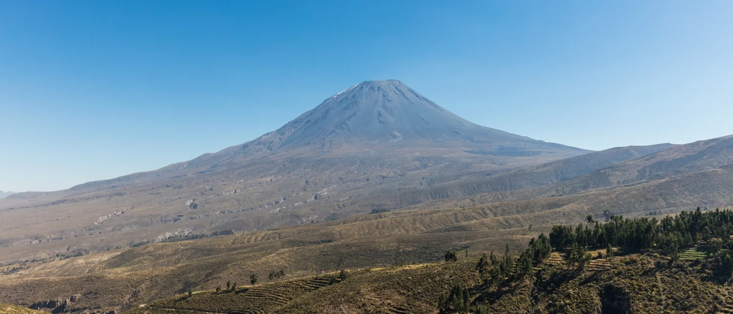
Misti stands in the southern Peruvian Andes, 12 kilometres from Arequipa, a city of more than a million people. The mountain reaches 5,822 metres, towers roughly 3.5 kilometres over the rooftops, and ranks among the most dangerous volcanoes in the world. 2
It last erupted seriously between 1440 and 1470. Arequipa was founded on 15 August 1540, seventy years later. 2 Everyone who has ever lived in the city has come after that eruption. None of them saw it.
A mountain with a dog's name
Misti is a young, symmetrical cone with slopes of about 30 degrees, roughly 20 kilometres across at its base and built from stubby lava flows and pyroclastic rock. 2 Snow covers the top but does not persist, and there are no glaciers; the upper slopes carry almost nothing, while scrub, cacti and cushion plants take over lower down. 2
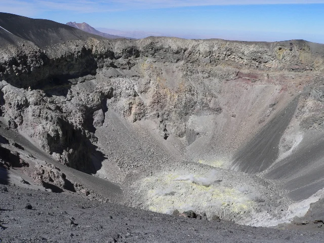
The summit holds two craters, one inside the other. The outer is 835 to 950 metres wide and 120 metres deep. The inner one, in the southeastern part of the outer, is 550 metres wide and 200 metres deep, and its walls cut through metre-thick ash and older lava domes. At the bottom of the inner crater sits a plug of rock 120 metres wide and 15 metres high, cracked and strewn with boulders, ringed with sulphur and venting gas. 2 The highest point of the volcano is on the northwestern rim of the outer crater, where an iron cross marks it. 2
The name is the first thing about the mountain that resists one answer. "Misti" may come from Quechua or from Spanish, and it means 'mixed', 'mestizo' or 'white', possibly a reference to the snow. The older names are indigenous: Putina, and the Aymara Anukara or Anuqara. Sources used Putina until the 1780s, when "Misti" begins to appear. Some Spanish chroniclers confused the volcano with Ubinas and Huaynaputina. 2
Arequipa calls the mountain its house mountain, and puts it on the city's seal. 2
How the mountain was built
Off the Peruvian coast, the Nazca Plate slides beneath South America at five or six centimetres a year. The fluids it releases as it descends melt the mantle above it, and that process built the Central Volcanic Zone, which runs 1,000 to 1,500 kilometres from southern Peru through Bolivia to northern Chile and Argentina and accounts for more than 400 volcanoes in Peru alone. 2 Chachani, dormant, stands 15 kilometres northwest, and Pichu Pichu, extinct, 20 kilometres southeast. Misti is the youngest of the three. 2
The cone grew in four stages. Each stage laid down lava flows and domes and ended with the summit collapsing into a bowl. The present mountain began to rise about 112,000 years ago; a caldera six kilometres by five formed between 50,000 and 40,000 years ago; later domes filled it in again. 2
That history amounts to a schedule, and the schedule is what makes a neighbour 12 kilometres away survivable. Sub-Plinian eruptions take place roughly every 2,000 to 4,000 years, ash fallout every 500 to 1,500 years, and the largest ignimbrite-producing eruptions every 10,000 to 20,000 years. More than ten eruptions have happened in the last 11,000 years, with only brief pauses between them. 2
The last two big eruptions
About 2,000 years ago Misti produced the last major explosive eruption of its history, in one event or several, best dated to between 2,060 and 1,920 years before the present. It threw out roughly 0.4 cubic kilometres of rock, probably within a few hours, on a scale the article compares to the 1902 eruption of Mount Pelée. Pumice fell 25 kilometres from the vent and an eruption column rose 29 kilometres into the sky. 2
The eruption began as magma rose into an older body of rhyolitic rock, driving steam explosions before the conduit cleared. The mixed pumice it left behind has the look of chocolate and vanilla swirls. Pyroclastic flows came down the southern flanks, possibly through the gap in the crater rim, and mudflows followed them. The outer summit crater probably formed in this eruption. 2 Tephra that may belong to it has turned up in a peat bog near Sabancaya and, tentatively, in an Antarctic ice core. 2
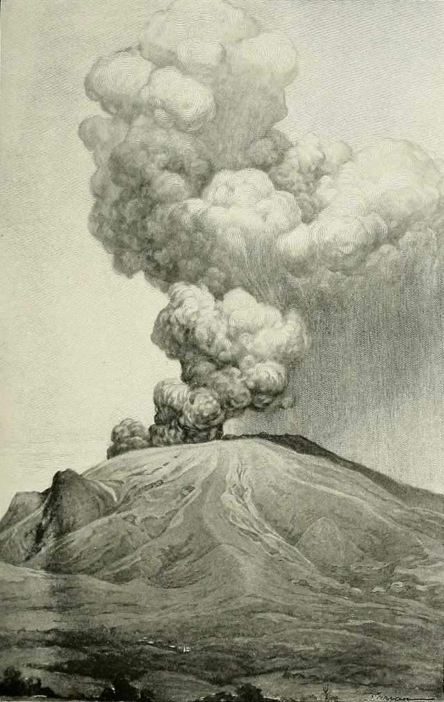
The eruption that closed Misti's active record ran from 1440 to 1470 and produced about 0.006 cubic kilometres of ash, a small fraction of the earlier one. It probably lasted months or years. Ash fell in the Peruvian Laguna Salinas and possibly as far as the Siple Dome and Law Dome in Antarctica, and the eruption may have affected global climate alongside the beginning of the Spörer solar minimum. It is the oldest eruption of a South American volcano for which historical records exist. 2
The records are thin, and human. Mama Ana Huarque Coya, the wife of the Inca emperor Pachacutec, came to Chiguata to give assistance. No Inca settlement appears to have been destroyed, but the local population fled and the Inca had to resettle the area. 2 In 1600 the mountain was covered by ash from Huaynaputina, a neighbouring volcano whose eruption that year killed more than 1,000 people. 2
Since 1470 Misti has kept to smaller events: Vulcanian eruptions, mudflows and ash fall, dated at roughly 330, 340, 520, 620, 1,035 and 1,300 years before the present. Mudflows continued down the southern valleys into the 17th century. Possible steam eruptions are recorded in 1577, 1677, 1784 and twice in 1787, with a handful of questionable ones between 1542 and 1870. Those were probably fumarolic activity after heavy rain, when water soaked into the mountain and evaporated off its heat. 2
The children in the crater
The people of Arequipa venerated Misti as an apu, a mountain deity, and the late-16th-century chronicler Cristóbal de Albornoz counted it among the important mountains of the Inca Empire's Arequipa region, alongside Ampato, Coropuna, Sara Sara and Solimana. The traditions may be older than the Inca, who took them up after conquering the area. 2 The Aymara saw the mountain as an abode of the dead, benign in some accounts and fearful in others. 2
The Inca offered cups of gold and silver to the apus and settled people around Misti to keep the veneration going. Some communities shaped infants' skulls by cranial deformation to resemble the volcano. Accounts describe a mountain that was always demanding sacrifices, and in colonial times a pilgrimage was held to exorcise it. 2
In 1998 the anthropologist Johan Reinhard and the Arequipa archaeologist José Antonio Chávez found eight or nine mummies on Misti, inside the crater and below the summit. The dead were children, mostly boys of about six years old, in some cases buried one on top of another and, unusually for an Inca sacrifice, in shared tombs. Figurines, ceramics and other objects were buried with them; 47 figurines have been found on the mountain in all, a sign of how important the site was. The whole group forms the largest known Inca capacocha assemblage. The conditions inside the crater have badly damaged the bodies. 2
Those sacrifices, and others made on Chachani and Pichu Pichu, were probably a response to the eruption of 1440–1470. That may explain the unusual location: these burials were made inside the crater, where an Inca offering would not ordinarily have gone. 2 The 16th-century chronicler Martín de Murúa tells of the emperor Thupa Yapanki sacrificing llamas to calm a volcano called Putina near Arequipa and climbing as close to the summit as he could, after earlier ceremonies had failed to quiet it. The article reads that account as more likely describing the eruption of Huaynaputina in 1600. 2
The city that came seventy years later
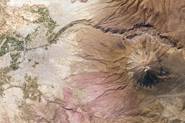
Arequipa was founded on 15 August 1540, on ground the volcano had made. The area was already densely populated, with canals, roads and buildings where the city now stands, and the city itself is built on mudflow and pyroclastic flow deposits. Every valley that drains Misti passes through Arequipa, directly or indirectly. 2 The white building stone called sillar comes from white pyroclastic flow deposits near the volcano, and the prevalence of that stone is why Arequipa is known as the White City. 5
After the Spanish conquest, the mountain was consecrated to St. Francis. The cross planted on the summit in 1784, after an earthquake destroyed the city, is said to protect it, and religious ceremonies are still held on the volcano. During episodes of increased activity the inhabitants of Arequipa have carried out public penance and flagellation to appease it. 2
The timing of the city's founding is the thing the article keeps returning to. The last eruption came shortly before Arequipa existed, so where earthquakes are remembered, eruptions are not. The city holds no inherited memory of what the mountain can do. 2 People in Arequipa have often treated the volcano as a protective figure, and many of them picture volcanoes as producers of lava flows, which at Misti would be the slowest and least lethal of its problems. 2
What an eruption would do
Misti is dangerous because of where it is. Arequipa's northeastern suburbs have grown onto the volcano's slopes, and some neighbouring towns and districts now come within 8 kilometres of the crater. About 8.6% of Peru's gross domestic product depends on Arequipa. At least 220,000 people live south of the mountain, where the ravines could channel flows into the urban area. 2
Lava is the hazard people picture, and at Misti it is the one with the smallest reach: it destroys whatever it touches but moves slowly enough for people to leave. The others arrive faster. 2
Ash fall and tephra can cause health problems, pollute water supplies, collapse roofs and bury fields. Both the eruption 2,000 years ago and the one in 1440–1470 laid tephra over what is now the city, and even a moderate eruption could do it again. Close to the volcano, large rocks can fall from the sky. 2 Mudflows, which are mixtures of rock and water set off by rain or by melting snow, happen at Misti on average once every century or two, and small ones can reach the city. 2 Pyroclastic flows carry gas and rock at 300 to 800 °C and travel at 200 to 400 kilometres an hour, cross topographic obstacles, and can run 13 kilometres from the vent, although the denser flows would probably stop before reaching the city. 2 The steep slopes raise the risk of a sector collapse, whose debris avalanche could travel further than the distance between the city and the mountain and could dam the Rio Chili. Gases can collect in closed spaces or fall as acid rain. 2
Three scenarios of a future eruption have been evaluated:
| Scenario | Modelled on | What it would do |
|---|---|---|
| Small | Recent activity at Sabancaya, or Misti's own eruption of 1440–1470 | Ash falls around the volcano, reaching 5 cm in the urban area and shutting Arequipa's airport; landslides could damage the dams on the Rio Chili while mudflows descend the southern slopes 2 |
| Moderate | Misti's eruption about 2,000 years ago | Ash more than 10 cm deep could collapse buildings; pyroclastic flows descend the steep southern slopes and reach the suburbs of Arequipa and Chiguata 2 |
| Plinian | Misti's "Fibroso" and "Sacaroso" eruptions, or the 1600 eruption of Huaynaputina | Pyroclastic flows sweep every flank and pass Arequipa, blocking the Rio Chili; thick ash falls across the whole region, including El Alto, La Joya and farmland. This scenario would require evacuating the city 2 |
Most risk assessments are based on the first two scenarios. 2 Two further hazards need no eruption at all: seasonal flooding runs through the same channels in the wet season, and heavy metals, probably from Misti and Chachani, have been found in river water. 2
The monitoring that arrived in 2005
For most of Arequipa's existence, nobody watched the mountain. In 2001 the city had neither emergency planning nor land-use planning for a volcanic eruption, and the development plan for 2002–2015 mentioned volcanic hazards without setting out specific measures. 2
Peru's Geological, Mining and Metallurgical Institute, INGEMMET, began monitoring volcanoes in 2005, starting at the Charcani V hot spring. Seismic monitoring began the same year, geodesic stations were installed from 2008, and a new monitoring station opened in 2012. The Peruvian Volcano Observatory was inaugurated in Arequipa in 2013 and watches Misti along with Ubinas, Ticsani and other volcanoes. By 2021 the network on Misti included seismometers, instruments reading the chemistry and temperature of springs and fumaroles, and sensors for any movement or deformation of the mountain itself. 2
The mountain does move, in small ways. Long-period earthquakes, tremors, "tornillos" and volcano-tectonic earthquakes are recorded, clustering on the northwest flank and apparently linked to the hydrothermal system beneath it. Swarms were recorded in August 2012 and in May and June 2014. Satellite images have shown no deformation of the volcano. 2
A hazard map, developed in 2005 and presented in early 2008, divides the area into high, intermediate and low hazard zones, and parts of Arequipa fall in the high-risk zone. It is the first hazard map of a Peruvian volcano; a 3D version followed in 2018. In 2010 the municipality decreed that the map must be considered in future city zoning decisions, and evacuation exercises were held for several suburbs in May 2009 and April 2010. 2
The signals themselves are ambiguous. Fumarolic activity has been reported since the eruption of 1440–1470 and was strong enough to be seen from Arequipa in 1948–1949 and 1984–1985. Fumarole temperatures generally run between 125 and 310 °C with peaks of 430 °C, and the system warmed between 1967 and 2018, which may mean new magma has arrived. Clouds rising off the mountain have been mistaken for renewed activity. 2
The record after the Spanish arrival is where the sources part. Most studies find no clear evidence of an eruption then. The Global Volcanism Program lists Misti's last eruption as 1985, and INGEMMET calls it the third-most active volcano in Peru. 2
Five things that are easy to get wrong
- The date of the last eruption. The Global Volcanism Program records one in 1985, and INGEMMET ranks Misti third among Peru's most active volcanoes. Most studies find no clear evidence of an eruption after the Spanish arrived, and the well-documented last eruption is the one of 1440–1470. The later dates more likely record fumarolic activity — the mountain smoking, often after heavy rain, sometimes mistaken for an eruption. 2
- Twelve kilometres. That is the distance between the volcano and the city as the article gives it. NASA's description of the astronaut photograph puts the city centre about 17 kilometres from the summit, and the closest districts come within 8 kilometres of the crater. The number moves with the two points being measured. 25
- Where the children were buried. The eight or nine mummies were found inside the crater and below the summit. Shared tombs and bodies stacked one on another are unusual for an Inca sacrifice, and the article offers the recent eruption as a possible explanation for a burial site inside the crater. 2
- Which eruption drives the planning. The event 2,000 years ago was Misti's last major explosive eruption and the only Plinian one of its Holocene. Risk assessments mostly rest on that event and on a small eruption like the one of 1440–1470. The Plinian scenario, drawn from Misti's older "Fibroso" and "Sacaroso" eruptions and from Huaynaputina in 1600, is the one that would require evacuating the city. 2
- How much of the hazard needs an eruption. Mudflows happen on the mountain on average once every century or two and can arrive with no eruption at all, set off by rain alone. Seasonal flooding uses the same channels, and heavy metals reach the river water. 2
In their own words
"mountain that growls"
The meaning of Putina, Misti's older name in the Puquina language. The Aymara names Anukara and Anuqara mean "dog", for the animal the mountain resembles when it is seen from the Andean plateau. 2
"Indian sorcerers"
The phrase the Jesuit College of Arequipa used for the people who, in its account, believed the volcano Huaynaputina had asked Misti for help in expelling the Spaniards. Misti refused, the story goes, saying it had already been Christianised, and Huaynaputina proceeded alone. 2
"the residents view themselves as the offspring of the mountain"
How the article summarises Arequipa's relationship with Misti, a mountain that appears on the city's own seal. 2
"there is no memory of the hazards of volcanic activity"
The article's explanation for why volcanic risk went unexamined in Arequipa for so long. The last eruption came shortly before the foundation of the city, and unlike earthquakes, eruptions left nothing behind for anyone to remember. 2
What the mountain has been asked for
Misti has been asked for a great deal. The Inca put children in the crater to quiet it, and left 47 figurines with them. The Spanish put a cross on the summit, and replaced it twice. Farmers in the valleys still hold that an offering to Misti brings the birth of boys while an offering to Chachani brings girls, and some geologists make an offering before starting fieldwork. 2
Since 2005 the mountain has also been asked for data. Seismometers, gas sensors and a hazard map have replaced guesswork in a city founded 70 years after the last eruption, which then waited 465 more for anyone to put an instrument on the mountain. Against all of that, comparisons between photographs of the volcanic plug taken in 1967 and images from recent years show no change at all. 2
The full account, with its citations, is at Misti on Wikipedia.
References
- 1Wikipedia: Today's featured article/September 20, 2026
en.wikipedia.org
- 2Misti - Wikipedia
en.wikipedia.org
- 3File: P1020738 El Misti Krater.jpg - Wikimedia Commons
commons.wikimedia.org
- 4File: The National geographic magazine (1902) (14595295848).jpg - Wikimedia Commons
commons.wikimedia.org
- 5File: El Misti Volcano and Arequipa, Peru.jpg - Wikimedia Commons
commons.wikimedia.org
This story was produced automatically by a channel. One sentence is all it takes for Neodrop to keep producing for you.
Related content
More from this channel
- Ashton-under-Lyne: 75 cotton mills, an 870-metre mine shaft, and a Bronze Age skull in a peat bog
- Noemvriana: 2,500 Allied marines, 20,000 royalists, and one day of fighting in Athens
- Eternal Blue: a desert rental house, an NSA hacking tool, and Spiritbox's debut album
- Grace Coolidge: a raccoon, a collie, and a president's rules