pubs.usgs.gov
Trans-Alaska Pipeline: how 124,000 heat pipes kept the ground frozen under 120 °F oil
The Trans-Alaska Pipeline was engineered to keep 120 °F oil from thawing the frozen ground that carries it; forty-nine years later its operating problem is oil that arrives colder and slower, and a thirty-year right-of-way renewal is being decided on that basis.
On 26 August 2026, the Bureau of Land Management opened a fifteen-day comment period on a thirty-year renewal of the Trans-Alaska Pipeline System's federal right-of-way. The line has been carrying North Slope crude since 20 June 1977, and in 2025 it averaged 462,821 barrels a day — the lowest annual figure in its history, against the 2.14 million barrels a day it was designed to move. 12
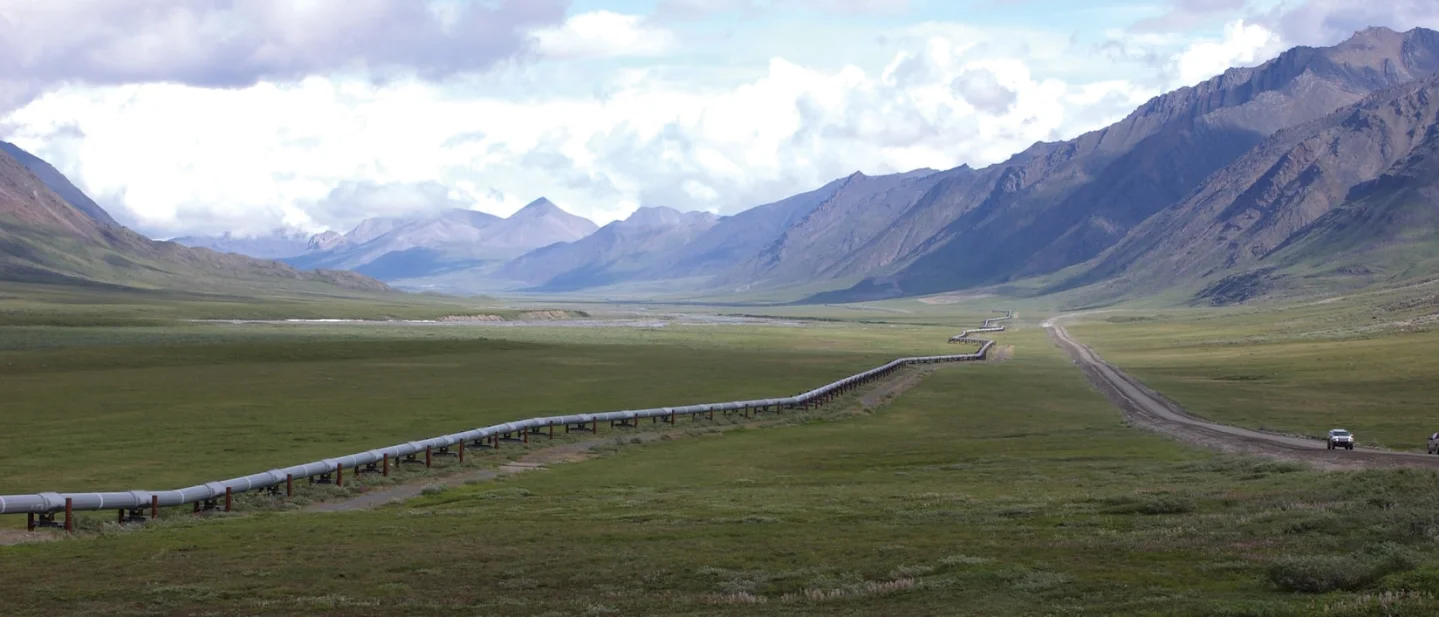
The renewal reopens a bargain that the pipeline's designers made with the ground under it. Crude leaves Prudhoe Bay at about 120 °F (49 °C). For most of the route it travels, the ground below is frozen year-round. Permafrost carries a pipeline because its ice bonds the soil together; warm it, and the soil loses the strength a foundation needs. The designers answered that by keeping the oil sealed inside insulated pipe and lifting the line into the air wherever the ground could not be trusted to stay frozen, using a passive device with no moving parts to chill the ground every winter.
That design worked, and then the premise moved. Throughput is down roughly 77 percent from its 1988 peak, the oil moves more slowly and arrives colder, and the operator now adds heat to keep it moving through a line whose original problem was the heat it already carried. This issue follows that chain — the constraint, the mechanism, the price, the failures, and what the thirty-year renewal actually decides.
The project at a glance
| Field | Trans-Alaska Pipeline System | What it forced |
|---|---|---|
| Purpose | Move North Slope crude 800.3 miles (1,288 km) from Prudhoe Bay to an ice-free port at Valdez | Tanker aircraft, submarine tankers, a railroad extension and an icebreaking tanker transit were all studied and dropped first 3 |
| Pipe | 48 in (1,219 mm) outside diameter; 466 miles at 0.462 in wall thickness, 334 miles at 0.562 in | Two steel weights: thicker where the line is buried and thinner where it rides on supports 3 |
| Route length | 800.3 miles of pipe along a 789-mile route | About eleven miles of extra pipe carries the zigzags that absorb thermal expansion and earthquake movement 3 |
| Support | 420 miles elevated about six feet above ground on more than 78,000 vertical support members | Keeps a hot pipe out of permafrost that loses strength when it thaws 34 |
| Thermal system | More than 124,000 sealed ammonia heat pipes inside those support members | Each support chills the ground it stands in whenever the air is colder than the ground 5 |
| Seismic provision | Teflon shoes sliding on long steel beams through a 1,900-ft (579 m) Denali Fault corridor, with no anchors inside the corridor | The design case was a magnitude 8.0 earthquake with 20 ft of horizontal and 5 ft of vertical ground offset 6 |
| Isolation | 178 valves along the line | Sectional isolation, so a leak or a repair stops the smallest possible length of pipe 3 |
| Pump stations | 12 designed, 11 built; eight running at startup, eleven by 1980, four as of December 2024 | Station count tracks throughput; the pumps are gas- or liquid-fuel turbines 3 |
| Design capacity | 2.14 million barrels a day | A ceiling that was met once: 1988 averaged 2,032,928 barrels a day 1 |
| 2025 throughput | 462,821 barrels a day, the lowest annual average on record | Cumulative volume reached 19.05 billion barrels by the end of 2025 1 |
| Terminal | Valdez Marine Terminal: eighteen storage tanks holding 9.18 million barrels, four tanker berths and two loading berths | Storage was sized to hold the line's own contents, so the whole pipeline can be emptied 7 |
| Regulatory status | Federal right-of-way renewal for thirty years, scoping opened 26 August 2026 | About half the route crosses federal land, and the state renewal runs alongside it 28 |
The constraint: oil at 120 °F, ground that stays frozen
Prudhoe Bay was a discovery before it was a design problem. Atlantic Richfield's discovery well began flowing in March 1968, and the field turned out to hold more than 25 billion barrels — the largest in North America. 3 Getting the oil to a refinery was the harder half. Boeing proposed a fleet of twelve-engine tanker aircraft; General Dynamics proposed tanker submarines running under the Arctic ice; another group proposed extending the Alaska Railroad to Prudhoe Bay. 3
The one option that got a full-scale trial was the sea route. In 1969 Humble Oil sent the tanker SS Manhattan through the Northwest Passage with an icebreaking bow, hardened propellers and more powerful engines. The ship's cargo holds flooded with seawater, and wind-blown ice forced it off its intended route and into the narrower Prince of Wales Strait. A second transit followed in the summer of 1970, and the concept was judged too risky. 3
That left a pipeline, and a pipeline through Alaska had to be designed for ground that most engineers in 1969 had never built on. Eight hundred miles of 48-inch steel pipe were ordered from Japanese mills in 1969, because American mills could not supply the volume then. 3 Legal fights over Native land claims and environmental objections held construction back for years; the authorisation came in 1974. 7
The survey work that decided the design started in spring 1970 and surveyed the route on foot through four mountain passes, cutting foliage so crews could advance as much as 20,000 feet a day. 7 It was the soil work, though, that set the form. Core samples drilled north of the Brooks Range in 1969 showed permafrost almost everywhere along the route, and the design moved above ground; a 1,000-foot test loop built near Barrow worked out how the elevated line should behave. 7
The physics behind that decision is worth stating plainly. Permafrost is ground that has stayed frozen for at least two years; in much of Alaska it is soil and gravel held together by ice. A buried hot pipeline would thaw the ice around it, the soil would consolidate, and the pipe would lose the support that buried pipe normally gets from the ground it sits in. Elevation solves that by taking the pipe out of the ground, at the cost of a structure to hold it up — a structure that itself has to resist thawing the ground it stands in.
Three other ground conditions pulled the design in different directions, and each left its own construction method on the route:
- Thaw-stable or unfrozen soil. Where the ground would not lose strength when warmed, the line was buried conventionally, with cathodic protection against corrosion in wet soil. 7
- Caribou crossings. Ecological objections required buried crossings so that migrating caribou could walk over the line. Engineers answered with 3.5 miles of refrigerated burial: brined chilled ground, Styrofoam-lined trenches and a gravel cover. 7
- Atigun Pass. The pass is avalanche terrain, so an elevated line was ruled out. Instead, 6,000 feet of pipe runs in a reinforced, insulated concrete box lined with 21 inches of Styrofoam. 7
Gravel became a structural material in its own right. It insulated the ground under camps and roads, and the project needed about 65 million cubic yards of rock, located across 470 sites in Alaska. 7 Where the line crosses rivers, concrete jackets weight the pipe so it sinks and stays down; the Yukon and Tanana crossings are bridges instead. 7
How 124,000 heat pipes keep the ground frozen
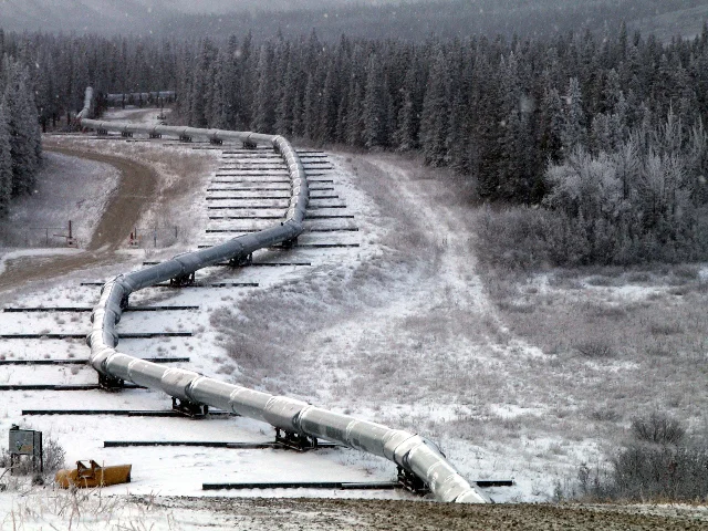
An elevated pipe needs piles, and those piles pass through the thing they are supposed to protect. Each above-ground section of the line is carried on vertical support members — steel piles driven into the ground and shaped like a capital H, with the pipeline resting on the cross stroke rather than welded to it. 4
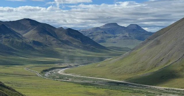
The pipeline rests instead of being fixed because it moves. Air temperature along the route swings by more than 150 °F between winter and summer, and an empty pipe can shift about twelve feet within an 1,800-foot section as it expands and contracts. 3 That movement is the reason the line is not straight: the route is 789 miles long and the pipe is 800.3 miles, with the difference held in zigzags that give expansion somewhere to go. 3
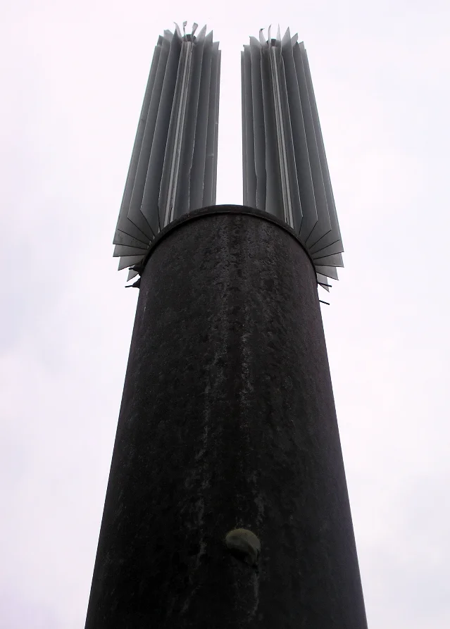
Each VSM in permafrost that is not thaw-stable carries a heat pipe — more than 124,000 of them were installed during construction in the mid-1970s, each a sealed tube of anhydrous ammonia. 5 The device has no pump and no power supply. Ammonia in the buried end absorbs heat from the ground, vaporises, and rises to a radiator above the surface. Winter air cools the vapour back into liquid, which falls to the bottom and starts again. When the air is warmer than the ground, the cycle stops. That one-way behaviour is the point: the pipe cannot pump summer heat downwards, so the net effect over a year is ground cooled toward winter temperatures. 7 The tubes are bored between 15 and 70 feet into the permafrost. 4
Four decades of operating those heat pipes produced a maintenance record worth reading, because it is what a passive thermal system actually costs. Non-condensable gas began appearing inside some heat pipes shortly after construction, displacing the ammonia and degrading performance. Alyeska researched the cause, tested how much performance the gas build-up cost, and tried "getter devices" to absorb it. That approach proved temporary. Recharging the affected pipes with carbon dioxide has worked, and remains the repair method. The same pipes now do a second job: ground temperature at the base of a thermal support is read off them at the end of each thaw season, which turns the thermal system into an integrity monitoring instrument. 5
The second constraint: the ground also moves sideways
The Pipeline Authorization Act required the line to survive the strongest earthquake recorded in the region it crossed. 7 In the early 1970s, geologists from the U.S. Geological Survey and Woodward-Lundgren and Associates worked with Alyeska to locate the Denali Fault, which crosses the pipeline route, inside a 1,900-foot corridor, and estimated that the line could face a magnitude 8.0 earthquake with 20 feet of horizontal and 5 feet of vertical ground slip. 6
Designing for a fault is a problem of uncertainty, because the geologists knew the fault was there without knowing exactly where its surface trace would appear. The corridor is the answer: inside it, nothing restrains the pipe. The line lies on Teflon shoes that slide on long horizontal steel beams set nearly flush with the ground, with the nearest anchors on either side of the corridor. When the ground moves, the pipe slides with it instead of being stretched or sheared. 610 The operators also designed for local failure: two consecutive support members can fail and leave roughly 180 feet of pipe unsupported while repairs are made. 10
The test came at 1 p.m. on 3 November 2002. A magnitude 7.9 earthquake ruptured the Denali Fault and broke the surface for 209 miles, crossing beneath the pipeline. The ground shifted about 13 to 14 feet horizontally and 2.5 feet vertically inside the corridor. 610 The line did not break. It shut down for 66 hours as a precaution while reconnaissance crews documented the corridor. 3
The damage report shows what the design absorbed and what it did not. Two support members were bent by contact with the pipe, eight intermediate supports and five intermediate shoes were damaged, nine anchors were tripped, eleven fault-crossing shoes were displaced, and about a hundred insulation modules were torn off. The ground also moved the pipe. Because of the angle at which the fault crossed the line, the pipe was pushed into compression — "we joke that we got an extra five feet of pipe out of the earthquake," the supervisor of the system engineering group said at the time — and crews then had to release that stored energy carefully through the anchors on either side. Where supports had failed, crews cribbed the pipe with timber so aftershocks could not drop it. Liquefaction and sand boils appeared around some support members and at a buried remote gate valve in a river floodplain; when the valve was excavated it was undamaged. 10
The economics of that outcome are unusually clear. The geological studies and the fault-crossing design cost about $3 million in the 1970s. USGS estimated that a rupture would have cost more than $100 million in lost revenue, repair and cleanup, "perhaps many times" more. 6
リンクプレビューを読み込んでいます…
Building it in three seasons
The pipeline could not be built before a road existed, and the road was its own project. The design contract for what became the Dalton Highway went out in February 1974; construction started on 29 April; Alyeska and four subcontractors deployed more than 3,400 workers, who built 360 miles of gravel road in 154 days, finished on 29 September, supplied by more than 700 flights a day and 170,000 flights in total. The road cost $185 million, shared between Alyeska and the state, which also designed and paid two-thirds of the Yukon River bridge. 7
The first winter showed how the project would be supplied. Between mid-January and the spring melt of 1974, 680 workers moved 34,000 tons of equipment north over hardened snow roads and an ice bridge across the Yukon, reopening seven dormant camps and building five more plus five temporary airstrips in 83 days. 7
Bechtel managed the line and Fluor managed the pump stations and the Valdez terminal, with the construction split among subcontractors on six line sections plus the terminal. 7 The steel arrived in 40- and 60-foot sections: 42,000 sections were welded into double joints and laid on the right-of-way, and 66,000 field girth welds joined the double joints into a continuous line. 3
Welding became the project's political crisis. Thousands of welds were questioned, most of them minor, but more than a thousand could have mattered and many were already buried and sealed where re-inspection was difficult. Congress held hearings; President Ford sent a team to Alaska; Alyeska began repairing on its own and had redone or certified more than 3,000 welds by September 1976. It asked for waivers on the remaining 612; Ford's team ordered 31 dug up and re-done. Three waivers were granted for welds buried 17 feet under the Koyukuk River, and proving those three took a novel inspection: the above-ground line either side of the Sagavanirktok River was cut, 48-inch fans were installed to move air, and twelve men and inspectors riding wheeled sleds pulled by a modified riding mower travelled the inside of the pipe with an ultrasound unit. Alyeska put the total cost of the weld rework at $55 million. 7
Labour scaled with the seasons. Employment rose from 12,000 in spring 1975 to more than 21,000 in the summer and fell to 7,000 by Christmas; the 1977 season needed fewer than 11,000. The final pipeline weld was made on 31 May 1977. 7
Valdez held a surprise of its own. Studies had predicted bedrock six feet below the surface at the terminal site; excavation found it sixty feet down, and 15 million cubic yards of overburden had to be removed. 7 Storage there was sized to hold as much oil as the pipeline itself, so the entire line can be drained, and a ballast-water treatment system was required by the authorisation act so that tanker ballast would not discharge oil into Prince William Sound. 7
Startup carried its own failures. Oil entered the pipe on 20 June 1977; a nitrogen leak on 4 July stopped flow for three days; on 8 July oil flowed through a shut-off pump at Pump Station 8 while workers replaced a strainer, and the spray ignited. One worker was killed, five were injured, and the station was out of service until March 1978. 7 The first barrel reached Valdez on 28 July 1977. The project cost more than $8 billion, and 32 Alyeska and contract employees died from causes directly related to construction. 3
What the design did not cover
The fault crossing was designed; most of what has gone wrong since was not, and the record separates into categories that behave differently.
People. The largest spill from the main line followed deliberate damage. On 15 February 1978, someone blew a one-inch hole in the pipe at Steele Creek east of Fairbanks; about 16,000 barrels escaped before the line was shut down, and it restarted after more than 21 hours. 3 On 4 October 2001, a gunman shot a weld near Livengood. About 6,144 barrels leaked, 4,238 barrels were recovered and reinjected, roughly two acres of tundra were removed in the cleanup, and the line restarted more than 60 hours later. 3
Equipment. On 8 January 2011, a leak appeared in the basement of the booster pump at Pump Station 1, the northernmost station. Flow was cut to 5 percent of normal for more than 80 hours while the leak was contained and a bypass was built around the affected section. 3
Water. Flooding has become the recurring hazard on parts of the route. In May 2019 the Dietrich River north of Coldfoot eroded 25 to 50 feet of bank and left an 80-foot buffer between the river and the pipeline; three months later the Sagavanirktok River eroded about 100 feet and left a 30-foot buffer. The Lowe River flooded near the line in March 2019 and again in June 2020. 3
Thaw. In 2021, state regulators approved emergency defensive work 57 miles northwest of Fairbanks, at a section of about 810 feet near pipeline milepost 392, where thawing permafrost had caused slope creep that tilted and bent braces holding the pipeline. The state could find no earlier record of permafrost slumping damaging the supports, or of thermosyphons being deployed as a safeguard once a slope had already started to move. The approved fix was roughly 100 free-standing thermosyphons driven 40 to 60 feet into the ground, plus a three-foot layer of insulating wood chips on top. 4
The aggregate numbers are smaller than the incidents suggest. Federal pipeline records covering the twenty years to 2021 list 18 breaches of the line, spills ranging from less than one barrel to 6,800 barrels, 9,784 barrels spilled in total, and $52.7 million in damages and costs — with none of those recorded spills attributed to permafrost thaw. 4 The state pipeline coordinator's summary of the operating philosophy behind all of it was shorter: "If it's frozen, keep it frozen." 4
The line's own floor
The pipeline was designed with a capacity ceiling and no stated minimum, because in 1974 nobody had to think about one. Fifty years of declining North Slope production have made the floor the harder problem.
Peak flow came in 1988, when the line averaged 2,032,928 barrels a day, carried about 25 percent of United States oil production, and pushed crude from Pump Station 1 to Valdez in about four and a half days. By 2018 the same journey took eighteen days. 13 The pump stations follow the volume: eight ran at startup, eleven by 1980, and four were moving oil as of December 2024 — Pump Stations 1, 4, 5 and 9. 3
| Year | Daily average (barrels) | What the year established |
|---|---|---|
| 1977 | 610,408 | First oil entered the pipe on 20 June, so the year covers half a year of operation 1 |
| 1988 | 2,032,928 | Peak year, at about 25 percent of U.S. oil production 13 |
| 2019 | 490,366 | First year below 500,000 barrels a day 1 |
| 2024 | 464,784 | Down from 469,196 in 2023 1 |
| 2025 | 462,821 | Lowest annual average in the line's history; cumulative volume passed 19 billion barrels 1 |
| 2026 to August | 458,570 | Year-to-date average, below the 2025 figure 1 |
リンクプレビューを読み込んでいます…
The operator describes the mechanism at work here as a chain: less oil means slower-moving oil, slower oil means colder oil, and colder oil makes everything harder. 12 Four consequences follow from the same physics.
- Water separates out. North Slope crude carries small amounts of water. As the oil slows and cools, water drops out and collects at low points, raising corrosion risk; during shutdowns it accumulates where the line sags. As water drops out and temperatures fall, the risk of ice problems rises. 12
- Wax deposits. North Slope crude contains up to 2 percent wax by volume. Wax crystals stick to pipe walls when the wall is below 70 °F and colder than the oil moving past it. Less turbulence, cooler crude and slower flow all push more wax onto the wall and drop more of it out of the oil. Cleaning pigs remove it. 12
- Pigging gets harder. Sludge drop-out, weaker leak detection and reduced ability to move pigs through the line are all listed consequences of operating below the flows the line was built for. 13
- The ground itself moves. As operating temperatures decline, the buried sections can be displaced by soil freezing and thawing, another item on that same list. 13
The mitigations in place now are a mix of heat and cleaning. Alyeska adds heat to keep the crude warm and to stop small amounts of water freezing in the line, and it has modified the pigging programme: pigs run less often, a pig-washing station was installed at Pump Station 8, and different pig designs are in use. Other options are being validated through laboratory and field tests. 12 The company reports reliability above 99.8 percent in recent months, with no prorations in most of 2026. 1
Where the floor sits has been studied twice over. The operator's Low Flow Impact Study, released on 15 June 2011, found that the onset of low-flow problems could begin around 550,000 barrels a day without mitigation, and that below 350,000 barrels a day considerable investment would be needed to keep the pipeline operating. The Energy Information Administration reported those thresholds and built them into a long-range scenario: it assumed the North Slope fields would be shut in and the pipeline decommissioned when throughput fell to 350,000 barrels a day and North Slope oil revenues fell to $5 billion a year. 13 Those thresholds date from 2011 and 2012. Throughput in 2025 and 2026 has run above both, and the mitigation programme is what keeps it there.
What the thirty-year renewal decides
The renewal process that opened in August 2026 is the framework within which those numbers get argued. The Bureau of Land Management is preparing a thirty-year renewal of the federal right-of-way, with a scoping period that ran from 26 August to 10 September 2026. The applicant is Alyeska Pipeline Service Company, on behalf of three owner companies: Harvest Alaska, ConocoPhillips Transportation Alaska and ExxonMobil Pipeline. 2
Two details of that process matter for anyone reading it as an engineering decision. The first is scope: about half the route crosses federal land, which is why a federal authorisation is needed at all, and the state is due to issue its own right-of-way renewal alongside it. 8 The second is the form of review. The previous renewal, made final in January 2003 just before the original agreement was due to expire in 2004, ran through a full environmental impact statement that began in November 2000 and examined the effects of aging on the structure, long-term changes to permafrost and oil spill risks. This time the agency is preparing an environmental assessment, a less comprehensive document, under department rules that set strict timelines and page limits, with a fifteen-day public comment period. 8
The case for renewal rests on new oil. BLM's Alaska state director called the pipeline "still an engineering marvel and only growing in its importance," and tied the renewal to unlocking the National Petroleum Reserve in Alaska and the Arctic National Wildlife Refuge coastal plain. 2 The Center for Biological Diversity criticised the compressed schedule in a statement, arguing the process should be thorough and public. 8
Three developments are the actual supply argument. ConocoPhillips' Nuna project added its first oil on 17 December 2024 and is expected to peak near 20,000 barrels a day. 14 Santos announced first oil from Pikka phase 1 in May 2026, with an initial ramp to 20,000 barrels a day gross, 28 wells drilled, and a plateau of 80,000 barrels a day gross targeted during the third quarter. 15 ConocoPhillips' Willow project is estimated at 180,000 barrels a day at peak, with first oil targeted for 2029. 14
Against that, the operator's own monthly figures through August 2026 average 458,570 barrels a day, a little below the 2025 average. Alyeska says the best long-term solution for the line is more oil, and predicts throughput will climb in the years ahead. 12 Whether the renewal's thirty years are full of oil is what the next decades of production from Nuna, Pikka, Willow and whatever follows will settle.
リンクプレビューを読み込んでいます…
What transfers to another project
Four things about this case carry to other infrastructure built on ground that has a future of its own.
A design that depends on a physical state inherits that state's future. The thermosyphons were built on a prediction — that the ground under the supports stays frozen — and that prediction has an expiry that depends on climate, which is why 2021 brought the first cooling field installed to stop a slope already moving. The passive device worked; the assumption it served is now a maintenance programme with a budget.
Naming the uncertainty and designing for it beats pretending to resolve it. The Denali Fault corridor was a 1,900-foot box drawn around a hazard whose exact position nobody knew. Inside it, the engineers removed every restraint and let the pipe slide. In 2002 the rupture arrived at 13 to 14 feet of horizontal offset, inside the 20-foot design case, and the line stayed whole. The tolerance, rather than the prediction, is what carried the load.
A capacity envelope has a floor, and the floor is a recurring cost. Below a certain throughput, this line needs heat it never needed before, more careful pigging, and different pigs. The floor moves with the oil's temperature rather than its price, which is why an operator can be profitable at 460,000 barrels a day and still spending more on flow assurance every year.
A right-of-way renewal is where the engineering assumptions get re-argued in public. The last renewal took three years and a full environmental impact statement that looked at aging, permafrost and spill risk. This one is an environmental assessment with a fifteen-day comment window. The reader can now see which review produced the terms the next thirty years will run on.
参考ソース
- 1Alyeska Pipeline, Historic Throughput
alyeska-pipe.com
- 2
- 3Wikipedia, Trans-Alaska Pipeline System
en.wikipedia.org
- 4Inside Climate News, "Thawing Permafrost has Damaged the Trans-Alaska Pipeline"
insideclimatenews.org
- 5
- 6
- 7Wikipedia, Construction of the Trans-Alaska Pipeline System
en.wikipedia.org
- 8
- 9Wikimedia Commons, "Pipeline vertical support member"
commons.wikimedia.org
- 10Alyeska Pipeline, "2002: The Denali Fault Earthquake"
alyeska-pipe.com
- 11Wikimedia Commons, "Trans Alaska Pipeline Denali fault shift"
commons.wikimedia.org
- 12Alyeska Pipeline, "TAPS Operations: Flow Assurance"
alyeska-pipe.com
- 13
- 14
- 15
このコンテンツはチャンネルが自動で生成しました。一言伝えるだけで、Neodrop があなたのために作り続けます。