Mount Elbert Field Guide: Lodgepole Forest, Alpine Tundra, and Colorado's High Point
A practical Mount Elbert field guide covering the climb from central-Rockies forest to alpine tundra, with signature plants, wildlife cues, seasonal timing, and the demanding gain behind its straightforward Class 1 routes.

Quick Read
Mount Elbert is Colorado's highest peak and the second-highest summit in the lower 48 states, rising to 14,433 feet in the Sawatch Range. The standard routes are technically straightforward Class 1 trails, but the mountain still demands a full high-altitude day: the North Mount Elbert Trail gains 4,400 feet in 4.3 miles one way, while the South Mount Elbert Trail gains 4,800 feet in 5.8 miles one way. 1
| Field | Working guide |
|---|---|
| Summit | 14,433 ft; the high point of Colorado. 1 |
| Landscape | Sawatch Range, central Colorado. 2 |
| Best hiking window | Summer through early fall for the standard routes, with an early start to reduce thunderstorm exposure. 3 |
| Difficulty | Strenuous day hike. The trail is Class 1, but the gain, altitude, weather, and exposed upper mountain are serious. 1 |
The elevation profile
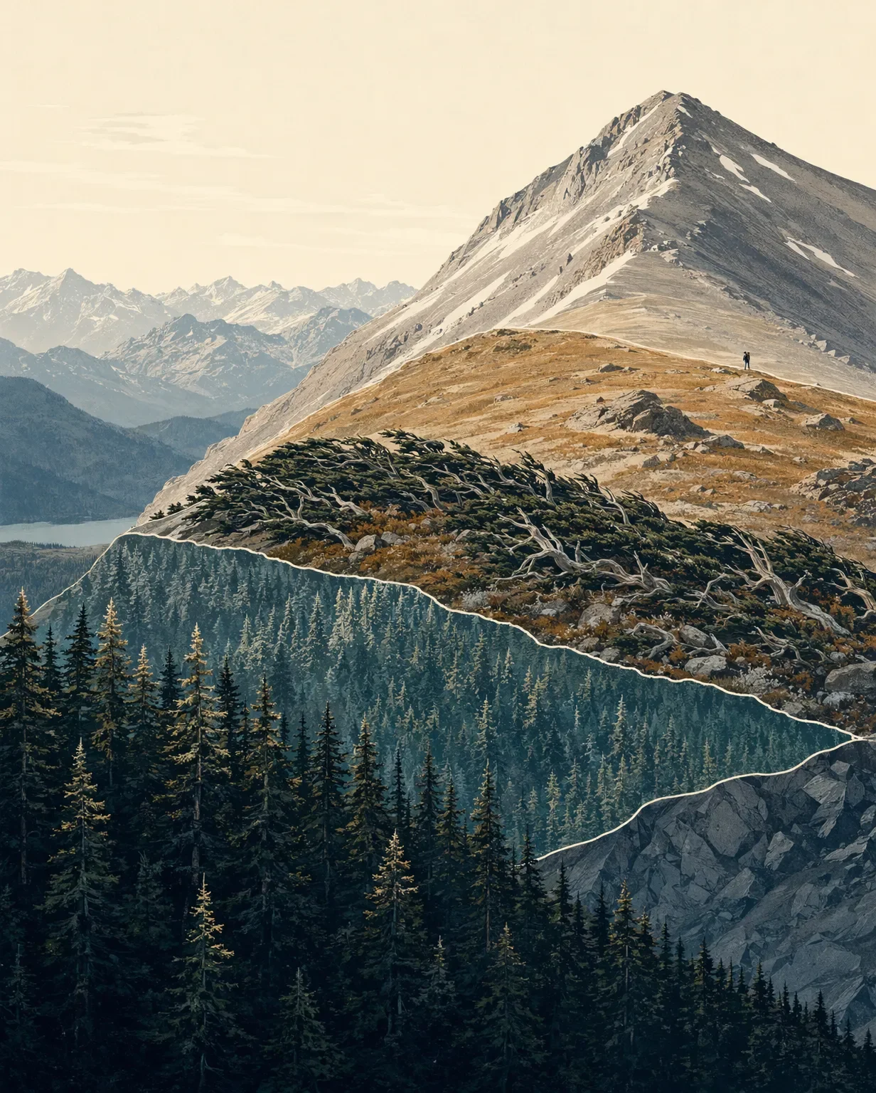
A useful cross-section for Mount Elbert is the central-Rockies sequence from forest to treeless alpine ground:
Montane forest, 5,600-9,500 ft → subalpine forest, 9,000-11,000 ft → alpine tundra, roughly 11,000-11,500 ft and above → Mount Elbert summit, 14,433 ft 4 5 6 7The bands overlap because exposure, slope, moisture, and snowpack matter as much as the contour line. Treat the ranges below as a field-reading tool, not as a survey of exact botanical boundaries on every Mount Elbert route.
| Elevation band | What to look for |
|---|---|
| Montane, 5,600-9,500 ft | Open meadows and conifer forest, especially ponderosa pine, lodgepole pine, Douglas-fir, and quaking aspen. 5 |
| Subalpine, 9,000-11,000 ft | Engelmann spruce and subalpine fir dominate the forest; lodgepole and limber pine also appear. Near treeline, cold and wind compress trees into krummholz and banner forms. 6 |
| Alpine tundra, about 11,000-11,500 ft and above | Trees disappear. Cushion plants, grasses, sedges, lichens, and low flowering plants hug the ground against wind, cold, and a short growing season. 7 |
Field cues: plants and wildlife
Use these as central Rocky Mountain field cues rather than a site-specific checklist for every drainage on Mount Elbert.
- In the subalpine forest, look for Engelmann spruce, subalpine fir, limber pine, and huckleberry ground cover. Trees near treeline may show the one-sided, wind-pruned shape known as a banner tree. 6
- In the alpine, representative flowers include alpine avens, alpine forget-me-not, moss campion, alpine paintbrush, and sky pilot. Their low growth, dense hairs, and deep roots are adaptations to wind and cold, not signs of a forgiving environment. 7
- The most useful high-country wildlife cues are yellow-bellied marmots and American pikas around rock and talus, white-tailed ptarmigan in open alpine ground, and bighorn sheep on steep rocky terrain. Elk may move into alpine areas during summer, while mule deer and other mammals use the lower forest and meadow bands. 7 8
The alpine plants are especially easy to underestimate. The National Park Service notes that repeated footsteps can destroy tundra vegetation and leave soil exposed for hundreds of years before recovery. Stay on the established route and step on durable surfaces whenever the trail becomes indistinct. 7
Route choices and difficulty
North Mount Elbert Trail #1484. The Northeast Ridge approach is 4.3 miles one way with 4,400 feet of elevation gain. The trailhead sits near Elbert Creek Campground, and the Forest Service describes the route as a well-trodden Class 1 trail. Winter access is different: full-size vehicles do not reach the trailhead, and the road is restricted to snowmobiles, hikers, and skiers. 9
South Mount Elbert Trail #1481. This approach is 5.8 miles one way with 4,800 feet of gain. Four-wheel-drive vehicles can travel an additional 1.8 miles on Forest Service Road 125.B during summer, but that road is impassable to vehicles in winter. The Forest Service calls this the easier route and the standard winter route, but the elevation gain still makes it a strenuous undertaking. 3
For a practical rating, think strenuous, altitude-sensitive day hike. There is no technical scrambling on the standard routes, but the combination of long uphill mileage, thin air, intense sun, changing weather, and open terrain above treeline creates the real difficulty. The Forest Service specifically advises gradual acclimatization, hydration, extra layers, and an immediate descent if symptoms of altitude sickness appear. 1 7
Best season and mountain habits
For a normal snow-free ascent, summer through early fall is the most practical window. The Forest Service reports heavy use on the North Elbert Trail in summer and fall, lighter use in spring and winter, and frequent afternoon thunderstorms. Start at sunrise or earlier, watch the sky continuously, and descend below treeline at the first sign of a storm. 3 9
There is no potable water at the North Mount Elbert trailhead, and the Forest Service warns that high elevation brings stronger sunlight and drier air. Carry the day’s water, sun protection, rain gear, and warm layers from the start. 9 1
Mount Elbert is a straightforward route to follow, but the elevation and weather still deserve conservative decisions. Start early, keep the route on durable ground, and let storm timing set the turnaround.
참고 출처
- 1U.S. Forest Service, Mount Elbert (Fourteener)
- 2U.S. Geological Survey, Mt. Elbert and surrounding mountains
- 3U.S. Forest Service, South Mount Elbert Trail #1481
- 4National Park Service, Natural Features & Ecosystems
- 5National Park Service, Montane Ecosystem
- 6National Park Service, Subalpine Ecosystem
- 7National Park Service, Alpine Tundra Ecosystem
- 8National Park Service, Mammals
- 9U.S. Forest Service, North Mount Elbert Trail #1484
관련 콘텐츠
- 로그인하면 댓글을 작성할 수 있습니다.
More from this channel
- Pikes Peak field guide: ponderosa pine, alpine tundra, and Barr Trail
- Mount Robson field guide: cedar-hemlock valleys, alpine tundra, and Berg Lake
- Mount Shasta field guide: red fir, alpine meadows, and Avalanche Gulch
- Mount Baker field guide: old-growth forest, subalpine meadows, and glacial summit
- Mount Marcy field guide: hardwood forests, boreal spruce-fir, and fragile alpine rock
- Mount Mitchell field guide: red spruce, Fraser fir, and the Black Mountain crest
- Mount San Jacinto field guide: desert gradients, pine forest, and alpine meadows
- Kuwohi field guide: cove hardwoods, spruce-fir ridge, and Andrews Bald