Palm Jumeirah: building the world's largest artificial island
How engineers moved 94 million m³ of GPS-guided hydraulic fill, designed a crescent breakwater around a mid-construction tidal flaw, compacted carbonate sand against liquefaction, and sank 12 immersed concrete tunnel monoliths to build Palm Jumeirah — and how every trade-off shaped every artificial island project that followed.

In the summer of 2001, Sheikh Mohammed bin Rashid Al Maktoum gave Nakheel Properties an instruction that sounded impossible: build a palm-tree-shaped island in the Arabian Gulf, large enough to add 78 kilometres of beach to Dubai's 72-kilometre coastline, using only natural materials. No concrete shapes. No imported sand from inland deserts. The material had to come from the sea itself.
That directive set off nine years of engineering problem-solving that has not been fully replicated anywhere at comparable scale since. The Palm Jumeirah — 5 km from trunk tip to the north end of the crescent, 94 million cubic metres of dredged sand, 7 million tonnes of blasted mountain rock, a six-lane subsea tunnel, a 5.45 km monorail, and a design flaw in the breakwater discovered mid-construction — is the result. 1
What makes it worth examining in engineering detail is not the scale alone. It is that almost every major decision — how to place the sand, how to design the breakwater, how to compact the fill against liquefaction risk, where to put the tidal gaps, and whether to build a bridge or tunnel to the crescent — involved a genuine trade-off with engineering consequences that only became fully visible after the fact.
Why an artificial island, and who built it
Dubai's problem in 2001 was straightforward: the city's Jumeirah Beach — the stretch of Arabian Gulf coastline running southwest from the city centre — was finite. With international tourism and real estate investment accelerating, Nakheel needed more prime beachfront without cutting further into the natural coast. 1
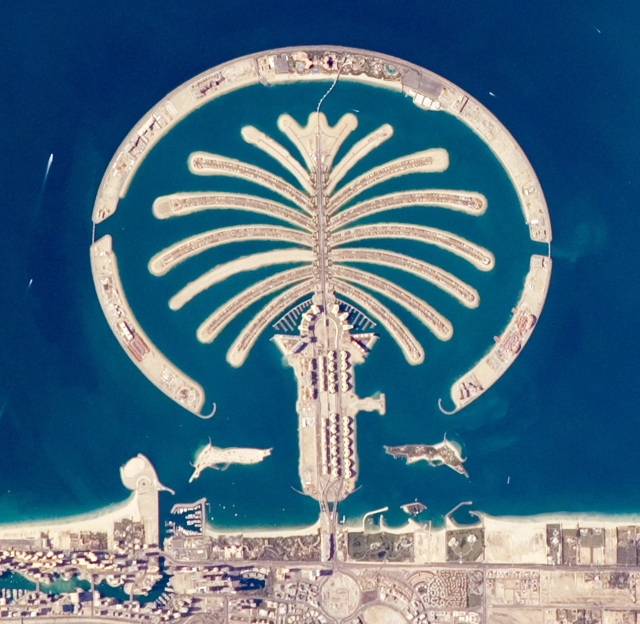
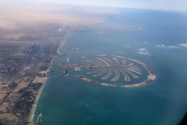
Sheikh Mohammed's solution was to build outward into the sea, creating new land rather than consuming existing shoreline. The palm tree shape was deliberately chosen: the trunk, 17 fronds, and the encircling crescent breakwater maximise beachfront per unit of reclaimed area more efficiently than a rectangular or circular island of equivalent footprint. A simple semicircle would have created a large central lagoon with relatively little beach edge. The branching frond geometry multiplied that edge geometrically — the palm delivers roughly 560 hectares of new land with 78 to 120 km of new coastline, depending on how the measurement is taken. 2 3
The project structure was elaborate. Nakheel Properties acted as developer. Van Oord, a Dutch specialist dredging company, was the lead dredging contractor. Archirodon Construction (Overseas), a Geneva-registered firm, held a parallel construction contract awarded in 2002. 1 WSP provided program management and infrastructure engineering, completing its work in 2010. 3 The concept design came from Helman Hurley Charvat Peacock (HHCP), an American firm known for theme park work at Sea World and Disney — an unusual pedigree for what would become one of the most demanding marine engineering projects of its era. Physical scale model testing was conducted by Sogreath Gulf in Dubai, using a 3D model subjected to a 12-metre random wave generator. 4 WL Delft Hydraulics in the Netherlands handled numerical tidal modelling.
Construction began in June 2001 and proceeded under extreme time pressure. By April 2002 — only eight months in, with just 550 metres of the crescent breakwater completed — Nakheel instructed contractors to begin frond reclamation simultaneously with breakwater construction. That parallel sequencing was unusual. Normally you would build the shelter structure first and then fill behind it. Proceeding simultaneously compressed the schedule but added significant complexity to site logistics: dredging vessels working the fronds had to navigate an incomplete and constantly extending breakwater. 4
First residential units were handed over in 2006. By October 2007, 75% of properties were ready. The 28 hotels on the crescent had opened by end of 2009. 1 The island now supports a permanent population of over 25,000 people. 1
Finding the right sand
Sheikh Mohammed's insistence on natural materials was not arbitrary aesthetics. Desert sand — the abundant local alternative — is too fine and too rounded for structural fill. Wind-driven desert grains are well-sorted and nearly spherical; they do not interlock. Marine sand, dredged from the seafloor, is coarser and more angular from mechanical wave action, and it locks together under load with far better bearing capacity. Hydraulically placed marine sand also compacts more predictably, which matters for what came later in the liquefaction analysis.
Van Oord sourced the sand from the Persian Gulf seabed approximately 6 nautical miles (11 km) offshore — deep water, away from inshore shoals that might have been ecologically sensitive or too shallow for the large trailing suction hopper dredgers (TSHDs) required. 5 The total volume placed was 94 million m³ — equivalent, for scale, to filling the Burj Khalifa roughly 11,000 times. 1
The placement method was "rainbowing": sand is pumped through the bow of the dredging vessel and discharged in a high-pressure arc onto the shallow reclamation area, building up the island mass layer by layer. As Van Oord described it: "The sand is sprayed by the dredging ships, which are guided by DGPS, onto the required area in a process known as rain-bowing." 5
The guidance system was the critical innovation. There are no fixed survey markers in the open sea. To achieve the intricate palm geometry — fronds curved at precise angles, with consistent widths and separations — the dredging vessels used Differential Global Positioning Systems (DGPS), which deliver positioning accuracy to within 1 cm by comparing the vessel's GPS reading against a fixed reference station on shore. 4 Without DGPS, maintaining the geometry of 17 individually curved fronds across a 5 km span would have been unachievable with dredging equipment operating from a moving vessel.
The hopper dredgers work in a cycle: they trail a suction pipe along the seabed, filling their hold with a slurry of sand and seawater, then travel to the reclamation area and discharge. Rainbowing discharges the slurry in a high arc — the water falls back into the sea, and the heavier sand grains carry further and settle on the growing fill platform. The cutter suction dredgers (CSDs) played a different role: a rotating cutter head at the end of a boom physically excavates the seabed and feeds material directly via a long floating pipeline to the reclamation area, without the vessel having to move between dredging and discharge positions. CSDs are slower but give finer positional control, which made them the instrument of choice for shaping frond edges and fill boundaries to the DGPS plan.
At peak construction, the site ran with approximately 40,000 workers per day, many of them accommodated on anchored cruise ships and on the fronds themselves as fast as they were built. 1 The construction logistics were in themselves a substantial management challenge: a moving construction site in open water, with no fixed land base within the island footprint for months at a time.
The breakwater: 11 km of rubble mound engineering
The crescent breakwater is the structure that makes Palm Jumeirah physically viable. Without it, the fronds would be exposed to open-sea wave action from the Arabian Gulf — wave heights and surge sufficient to erode the hydraulic fill continuously. The crescent had to dissipate that energy before it reached the residential fronds behind it.
The structure is a rubble mound breakwater: a cross-section built up from fine material at the core through progressively larger rock layers to heavy armour rock on the exposed seaward face. This design absorbs wave energy through friction and turbulence within the rock mass, rather than reflecting it (as a vertical wall would) or transmitting it through. 4
The crescent runs approximately 11 km in length and 200 m wide in cross-section. 2 Its crest stands 3 to 4 metres above mean sea level — roughly 13 feet above low tide — which places it well above the normal wave run-up height for the design sea state. The seaward water depth at the deepest point of the breakwater foundation reaches approximately 10.4 m (34 feet). 6 The seaward slope is 1:2 (one unit rise for every two units of horizontal run), which is the standard angle for stable armour rock under wave loading of this type.
The armour layer uses 3 to 6 tonne rock — blasted mountain rock sourced from over 16 quarries in Dubai and surrounding areas. 2 Total rock placed was approximately 7 million tonnes (with some sources citing 5.5 million m³, a figure consistent with a bulk density around 1.3 t/m³). 1 The rock layer builds from the bottom: coarse sand base, quarry run (unsorted blasted rock), 1-tonne secondary armour, then the 3–6 tonne primary armour on the exposed face. A floating crane placed a "toe" of rock on the inner (lagoon) face to protect the base from erosion.
Rock was deliberately chosen over concrete armour units — Accropodes or Dolosse of the type common in European breakwater construction. The rationale was ecological as well as structural: pre-construction surveys found that 95% of survey grid points on the reclamation footprint were bare sand and mud with virtually no marine life. Natural rock would eventually colonise with organisms — algae, invertebrates, fish — in ways that poured concrete shapes would not replicate. The crescent has since developed approximately 40 hectares of rocky reef habitat. 7
Physical model testing at Sogreath's wave tank verified the cross-section geometry and armour sizing against the design sea state before construction began. 4 Divers continuously surveyed the seabed and checked rock placement during construction, since there is no way to visually inspect underwater rock alignment from the surface.
One structural detail that does not appear in most published accounts: the crescent breakwater was not built on a flat, stable seabed. The foundation sits on the original Gulf floor, which is predominantly carbonate mud and silty sand — material with low bearing capacity. Before the rock could be stacked to design height, the foundation zone had to be prepared with a coarse sand layer to distribute the load and prevent uneven settlement of the rock structure itself. Settlement of the foundation material under the weight of 7 million tonnes of rock would change the freeboard — the distance between crest and mean sea level — potentially compromising wave attenuation years after construction was complete. Managing that settlement was a geotechnical challenge parallel to, but independent of, the fill compaction work on the fronds.
The stagnation problem: a design flaw discovered mid-construction
The original breakwater design was a continuous barrier — no gaps, no openings. This was structurally simpler and hydraulically safer from a wave transmission standpoint. What the original design did not adequately account for was tidal flushing.
The crescent, once completed as a closed circle, acted as a dam. Tidal water could not circulate naturally in and out of the 5 km² lagoon between the fronds and the crescent. Without circulation, the enclosed water warmed, oxygen levels dropped, and conditions that would have made the frond waterways biologically dead became a real risk — and an engineering liability for any resort or residential development depending on clean lagoon water. 1
WL Delft Hydraulics ran the numerical tidal modelling that identified this problem and proposed the fix: two 100-metre openings, one on each side of the crescent. These gaps allow tidal water to enter and exit the lagoon on each tidal cycle, replacing the enclosed water over time. 4
The redesign worked, but the tidal renewal rate is slower than open-sea conditions. Complete water circulation through the lagoon takes approximately 13 days — significantly slower than the natural flushing of open coastline but adequate to prevent stagnation. 8 Cavalcante et al. (2012), publishing in the Journal of Hydrology, confirmed through numerical modelling that lagoon residence time is long enough to affect dissolved oxygen levels, and that the gap configuration materially improves but does not fully replicate natural open-water conditions. 9
The placement of the two gaps was itself a trade-off. Gaps increase tidal renewal but reduce the breakwater's wave attenuation — any opening allows some wave energy to pass into the lagoon. The 100-metre gap width was the solution that balanced acceptable wave transmission against adequate tidal flushing. 4 Nick Henderson, a construction professional with RDrive who has worked on Middle Eastern coastal development, described this as the central lesson from Palm Jumeirah: "The main lessons were around water flow — that we ensure sufficient circulation within the Palm's outer breakwater to prevent stagnation." 10
A secondary consequence of the gap decision was the need for a retaining wall between the crescent and the fronds, with an additional rock apron in front to reduce wave overtopping from the water that did pass through. 4 Every design change generates secondary requirements.
Liquefaction: the invisible risk in hydraulic fill
Placing 94 million cubic metres of sand by rainbowing creates an enormous quantity of loose, saturated fill. Loose, saturated sand is inherently susceptible to liquefaction: when subjected to cyclic loading — an earthquake, for example — the sand grains lose contact with each other, pore water pressure spikes, and the material temporarily behaves like a liquid. Anything built on top sinks, tilts, or fails structurally.
The UAE sits at low-to-moderate seismic risk from the Zagros fault system in Iran, roughly 300 km to the northeast. The region is not highly seismic by global standards, but the probability of a damaging earthquake over a 50-year design horizon is not negligible — and 25,000 residents on an island built from loose marine fill represent a concentrated exposure. 1
There was a second complication specific to the Persian Gulf fill material. The sand dredged from the seabed is carbonate sand — grains composed primarily of calcium carbonate from the remains of marine organisms — rather than the silica-based quartz sand typical of most geotechnical literature. Carbonate sand grains are more angular and crushable than quartz. They respond differently to vibration: under the compaction probe, carbonate grains can fracture rather than rearrange, which complicates the relationship between applied vibration energy and achieved density. The engineering team had to work from a smaller published body of evidence on how to specify and verify vibro-compaction in carbonate material.
The solution was vibro-compaction: large vibrating probes are inserted into the loose fill, saturating it with water jets while vibration compacts the sand grains, expelling water and air and increasing relative density. The process converts loose, liquefiable fill into dense, stable ground. 2
The design target was demanding: settlement not exceeding 1 inch (2.54 cm) over the subsequent 50 years. 4 This is a tight specification. New fill always consolidates as excess pore water drains and grains rearrange; the vibro-compaction had to reduce that post-construction settlement to the point where structures built on the fronds would not tilt, crack, or require remediation within their design life.
Verification used Cone Penetrometer Testing (CPT) and Flat Dilatometer Testing (DMT) — downhole probes that measure soil resistance and stiffness in-situ without disturbing the sample. The CPT pushes a standardised cone tip through the soil at a constant rate; the resistance measured correlates with relative density and, through empirical charts, with liquefaction susceptibility. The DMT inserts a flat blade with an inflatable membrane, measuring soil lateral stress and stiffness. Together these tools gave the engineering team a spatial picture of where compaction targets had been achieved and where additional passes of the vibro probe were needed.
Published data from a 2015 Marchetti DMT conference paper by Sharif et al. confirmed that the vibro-compacted fill at the Crescent area showed an overconsolidated upper layer, consistent with successful densification. 1 CPT data published in 2012 (via Emerald insight) confirmed that vibro-compaction reduced the liquefaction potential of the carbonate sand fill to "low risk levels." 1
The 2009 subsidence discussion complicates this picture but does not undermine the ground improvement work. The New York Times reported in February 2009 that NASA laser altimeter satellites had measured Palm Jumeirah sinking at 5 mm per year. 1 Nakheel Properties responded that the satellite measurement resolution was 50 mm — meaning the instrument could not reliably detect deformation smaller than its own measurement uncertainty — and stated they had received no reports of structural problems on the island. 1 The disagreement between the NASA measurement and Nakheel's ground-level observations was never formally resolved by independent monitoring. No publicly available long-term subsidence data, such as an InSAR time-series, has been published for the island since 2009.
There is a meaningful distinction worth drawing here: even if the 5 mm/year figure is accurate, whether it represents ongoing consolidation settling toward the 50-year target, or structural subsidence exceeding the design specification, cannot be determined from the satellite data alone. The 50-year settlement budget of 25.4 mm spread over a decade would imply roughly 5 mm/year, which is consistent with both interpretations.
Connecting the island: tunnel, bridge, and horizontal drilling
The trunk spine connects to the Dubai mainland via gateway bridges — two road bridges, each carrying five lanes per direction, plus the dedicated monorail bridge. Getting traffic from the trunk to the crescent required a separate decision: a bridge or a tunnel. 4
The tunnel won. The engineering case for a bridge to the crescent was straightforward in structural terms but problematic for the lagoon. A bridge would have created a fixed barrier between the lagoon and the outer sea (beyond the tidal gap openings), disrupting the already-reduced tidal flushing by splitting the lagoon into semi-isolated sections. A tunnel, by contrast, passes entirely below the seabed and does not interrupt surface water flow in any direction.
The tunnel connecting the trunk to the crescent is a six-lane subsea structure — three lanes in each direction — approximately 1.4 km long, 40 m wide, and 25 m below sea level. It includes a service tunnel between the main traffic bores. Cost: AED 450 million (approximately USD 122 million at 2006 rates). 3
The construction method used a temporary coffer dam system: a sealed enclosure pumped dry to allow construction in the dry, protecting marine life during excavation. WSP documented that millions of gallons of seawater were pumped into the coffer dam daily while marine organisms were carefully removed and relocated before dredging. 3 WSP provided both program management and structural engineering for the tunnel. The tunnel was flooded and opened in 2009, connecting the Atlantis resort on the crescent to the main island trunk. 12
Connecting the fronds to the crescent for utilities required a different approach. Trenching across the open seafloor between each frond and the crescent would have disrupted the tidal circulation within the lagoon and disturbed the fill. The solution was horizontal directional drilling (HDD): boring horizontal tunnels beneath the seabed without surface disturbance, threading utility pipes through them.
Al Naboodah Engineering Services performed six HDD crossings. The eastern set ran 580 m at the water line (680 m average boring length per pass). The western crossings ran 700 m at the water line (800 m average boring length). The pipes were placed at 13 to 16 m depth below the seabed in water depths of 7 to 14 m. 8 The carrier pipes serve drinking water, telecommunications, wastewater, and treated sewage discharge. At frond-to-crescent transitions, where the drill path crossed the boundary between compacted fill and rock armour, vibro-compaction was applied specifically to stabilise the changing soil conditions along the drilling alignment.
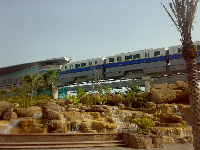
The Palm Monorail — the 5.45 km Hitachi straddle-beam line running along the trunk spine — was built by a Marubeni Corporation-led consortium. Hitachi manufactured four trainsets, each comprising three cars seating 70 people with room for 232 standing. 13 SYSTRA was commissioned by Marubeni between 2005 and 2008 for independent inspection, civil and rail systems validation, and safety file checking. 14 The line opened on 30 April 2009 as the Middle East's first monorail, with maximum speed of 70 km/h and a theoretical daily capacity of 40,000 passengers. 11
Actual ridership never came close to capacity: the line averaged approximately 600 passengers per day in its opening week and about 3,000 per day by 2017. 11 On 5 December 2025, the Palm Monorail was suspended indefinitely for "essential station maintenance." 11
The water and wastewater infrastructure is engineered to the same scale as the surface systems. Desalination plants produce potable water via reverse osmosis. The sewerage system — built by Corodex Electromechanic (Concorde-Corodex Group) — uses a vacuum collection system: 900 collection chambers and 40 km of pipeline feeding a membrane bioreactor (MBR) treatment plant on the trunk. 8 Treated water is reused for irrigation. The system, completed in August 2008, serves 2,000 villas.
Key specifications
| Parameter | Value | Source |
|---|---|---|
| Total area created | ~560 hectares (5.6 km²) | 1 |
| Extension into Arabian Gulf | 5 km | 1 |
| Number of fronds | 17 | 1 |
| New coastline added | 78–120 km (sources differ) | 4 3 |
| Sand volume placed | 94 million m³ | 1 |
| Sand source | Persian Gulf seabed, ~11 km offshore | 5 |
| Breakwater length | ~11 km | 2 |
| Breakwater cross-section width | ~200 m | 2 |
| Breakwater crest elevation | 3–4 m above mean sea level | 4 |
| Armour rock size | 3–6 tonnes per stone | 4 |
| Total rock placed | ~7 million tonnes | 1 |
| Rock quarry count | 16+ quarries in Dubai | 2 |
| Tidal gap width | 2 × 100 m openings | 4 |
| Tidal renewal cycle | ~13 days | 8 |
| Settlement specification | ≤1 inch (2.54 cm) over 50 years | 4 |
| Subsea tunnel length | ~1.4 km | 3 |
| Subsea tunnel dimensions | 6 lanes, 40 m wide, 25 m below sea level | 3 |
| Tunnel cost | AED 450 million | 4 |
| Monorail length | 5.45 km | 11 |
| Peak construction workforce | ~40,000 workers/day | 1 |
| Current population (2022) | 25,000+ | 1 |
Environmental consequences
The construction team knew before they started that building an island in a shallow, warm sea would have environmental costs. What they did not fully know was the scale.
Dredging disturbed the seabed over a large area, sending plumes of suspended sediment into the surrounding water column. Coral reefs were buried. Oyster beds were covered under approximately 2 inches of sediment. Subterranean sea grass meadows were destroyed. 7 Palm Jebel Ali, the second palm island, was placed directly on top of what had been the Jebel Ali Marine Reserve — the second most biodiverse marine ecosystem in the Persian Gulf — after its management was transferred from Dubai's environmental protection department to Nakheel. 7
The longer-term water quality data is stark. Mansourmoghaddam et al. (2022), analysing Landsat-7 and Landsat-8 satellite data from 2001 to 2020, found that sea surface temperature around Palm Jumeirah rose by 7.5°C over 19 years. 15 The paper also documented a rise in the Normalised Difference Turbidity Index (NDTI) of 0.118 to 0.172 and an increase in the chlorophyll proxy index (GNDVI) of 0.097 to 0.129, consistent with increased suspended sediment and algal growth. 15 During the COVID-19 lockdown in 2020, when visitor numbers dropped by 63 to 82%, those turbidity and chlorophyll indicators temporarily declined — a signal that ongoing human activity on the island, not just its construction, was sustaining the water quality degradation.
The effects extended beyond the Palm's immediate footprint. Subraelu et al. (2022), from UAE University, used Landsat time-series data to document that Dubai's offshore reclamation had contributed to shoreline retreat on the Ajman and Umm Al Quwain coasts: a net erosion area of 300 m² and an annual retreat rate of 30 m/year over the 2000–2021 period along the 22 km front coast of those two emirates. 16 The island altered longshore sediment transport patterns across a far wider zone than its own perimeter.
Nakheel's own environmental scientists, quoted in 2005, offered an honest framing of the dilemma: "There is a philosophical question as to whether habitat creation through rocky reefs, seagrass meadows and extensive intertidal beaches (70 km on Palm Jumeirah) is sufficient mitigation for our island building activities." 7 The crescent breakwater has developed into functional reef habitat. Dolphins, manta rays, and sharks have been recorded in the lagoon. Whether that represents genuine ecological compensation for what was destroyed during construction is, as Nakheel acknowledged, a question without a clean engineering answer.
Loading content card…
Legacy: what Palm Jumeirah changed
The most direct legacy is the immediate sequel. Palm Jebel Ali — 50% larger than Palm Jumeirah, with 16 fronds and over 90 km of planned beachfront — was begun around the same time but halted in the 2008 financial crisis. 17 Sheikh Mohammed bin Rashid Al Maktoum formally relaunched it in May 2023 with a new master plan. 18 In August 2024, Jan De Nul Group — a Belgian dredging company, distinct from Van Oord — was awarded a USD 200 million marine works contract by Nakheel, deploying 400 personnel to dredge 13 million m³ of sand using trailing suction hopper dredgers, vibro-compactors, and vibro stone columns. 19 Jan De Nul project manager Stijn Bruggeman described the coordination challenge: "This project is vast, with numerous activities occurring simultaneously. As soon as we finish a palm frond, another contractor begins work immediately. Hence, good coordination is essential." 19 In April 2026, Nakheel awarded contracts worth over AED 3.5 billion (USD 953 million) to build 544 villas, with infrastructure completion expected in Q4 2026. 18
The World Islands archipelago — 260 to 300 individual islands arranged in the shape of a world map, built by the Van Oord/Boskalis Dutch consortium that also worked on Palm Jumeirah — suffered a more troubled history. Construction was largely complete by 2008, but the financial crisis froze development. In 2011, Penguin Marine, contracted for island transport services, claimed the islands were "gradually falling back into the sea." Nakheel denied structural failure but confirmed sediment accumulation in the navigation channels. 20 Development eventually resumed: the Kleindienst Group's Heart of Europe project, covering six islands, opened its first hotel in December 2022 and a second in 2024. Full completion is targeted for 2027. 21
The influence on technique in other large-scale reclamation projects is real, though the specific knowledge transfer pathways are often undocumented. The same Dutch dredging companies — Van Oord, Boskalis, Jan De Nul — carry engineering experience across projects. The GPS-guided rainbowing technique used at Palm Jumeirah is now standard for large hydraulic fill operations globally. The lesson on tidal gap design — that enclosed lagoons require modelled flushing analysis before the breakwater is finalised — has been absorbed into coastal engineering practice. The combination of vibro-compaction with CPT and DMT verification, applied to hydraulically placed carbonate sand in a moderate seismic zone, has been referenced in subsequent Gulf reclamation projects including Dubai Islands (formerly Deira Islands/Palm Deira), restarted in 2024 under the Dubai 2040 Urban Master Plan. 2
Several engineering lessons from Palm Jumeirah have been absorbed into the general practice of large coastal reclamation, even where the direct project lineage is not always documented:
DGPS-guided hydraulic placement was not new at Palm Jumeirah — the technique existed before 2001 — but the project demonstrated that it could be applied at a scale and geometric complexity not previously attempted. Maintaining frond geometry to 1 cm accuracy over a 5 km span, from a vessel operating in 6-to-8 metre swells in the open Gulf, established a benchmark for what DGPS guidance could deliver. Subsequent projects — including the Hulhumalé expansion in the Maldives, which also used Dutch dredging contractors and hydraulic fill — adopted the same approach.
Pre-construction physical and numerical modelling together was the combination that caught the breakwater design flaw before it was too late to fix. The 3D wave tank model validated the cross-section geometry and armour sizing. WL Delft's numerical tidal model identified the stagnation problem that the physical model had not been set up to test. Neither model alone would have been sufficient. Using both, and accepting the redesign their outputs required, is the methodological lesson.
Breakwater rock over concrete armour was primarily an ecological choice, but it turned out to have practical engineering advantages as well. Rock is simpler to inspect — divers can assess rock displacement or settlement more directly than they can assess the structural integrity of interlocking concrete armour units. The crescent's rock armour has been maintained and replaced in sections over the life of the island, a process Van Oord returned to conduct in a later maintenance campaign. Concrete armour units, once displaced, are significantly harder to re-set to the correct orientation.
The broader academic critique of artificial island engineering has crystallised since Palm Jumeirah's completion. Alastair Bonnett, a geography professor at Newcastle University, wrote in March 2024 that projects like Palm Jumeirah risk "changing patterns of sediment deposition and erosion and creating silty, warm lagoons that turn living marine environments into dead zones." 22 That characterisation overstates the case for Palm Jumeirah specifically — the lagoon is not a dead zone, and the crescent reef supports significant marine life — but it accurately reflects the trajectory of less carefully managed projects elsewhere.
What Palm Jumeirah actually demonstrates is a more specific lesson: you can build a large, inhabited artificial island in a shallow tropical sea, but you cannot build one without consequences that extend beyond the island's perimeter, and you cannot design the breakwater correctly the first time without detailed tidal modelling. The engineers who revised the crescent design mid-construction to add tidal gaps did so because the numerical model told them what the original design could not have predicted without running the numbers. That revision is the technical detail most worth transferring to subsequent projects.
The WIRED Middle East framing from 2026 is apt: projects like Palm Jebel Ali "are not just real estate developments — they are long-term experiments in how technology, infrastructure, and environmental limits reshape where humans can live." 10 The first experiment is not finished — subsidence monitoring is incomplete, long-term lagoon ecology is unresolved, and the monorail that was supposed to serve 40,000 passengers per day is suspended with no reopening date. But the sand is there, the rock is there, and 25,000 people live on it. That part of the engineering worked.
Cover image: ISS photograph of Palm Jumeirah, Dubai, UAE (NASA ISS022-E-024940, public domain). Image from Wikipedia: Palm Jumeirah.
References
- 1Wikipedia: Palm Jumeirah
- 2Wikipedia: Palm Islands
- 3WSP: Palm Jumeirah
- 4CECR: Palm Jumeirah
- 5Van Oord: The transformation of Dubai
- 6CECR: Palm Jumeirah
- 7Mongabay: Dubai's artificial islands have high environmental cost
- 8DesignBuild-Network: The Palm Jumeirah Development
- 9Journal of Hydrology: Examination of residence time
- 10WIRED Middle East: The Gulf's Man-Made Islands Are Getting Bigger
- 11Wikipedia: Palm Monorail
- 12Tunnelbuilder: Flooding Begins on Subsea Palm Jumeirah Tunnel
- 13JORSA: Monorail Cars for the Palm Jumeirah Transit System
- 14SYSTRA: Palm Jumeirah Monorail
- 15MDPI Water: Assessment of Palm Jumeirah Island's Construction Effects
- 16MDPI Land: Land Reclamation and Artificial Islands in the UAE Coastal Zone
- 17Wikipedia: Palm Jebel Ali
- 18Palm Observer: Palm Jebel Ali timeline
- 19Jan De Nul: A palm shaped archipelago for Dubai, UAE
- 20Wikipedia: The World (archipelago)
- 21AX Capital: The World Islands — The Grand Revival
- 22Newcastle University: The Conversation — artificial islands
Add more perspectives or context around this Post.