
The lake that dried, returned, and kept a record of the Atacama
Wikipedia’s September 2 Featured Article follows Laguna Miscanti through groundwater, vanished shorelines, climate shifts, wildlife, archaeology, tourism, and water conflict.

A lake can look fixed because its surface is still. Laguna Miscanti, high in Chile's Atacama Altiplano, tells a different story: underground water keeps it alive, old shorelines show where it once stood, and sediments preserve the climate shifts that made the lake expand, shrink, and return. Wikipedia editors' article Laguna Miscanti, selected as Wikipedia's Today's Featured Article for September 2, 2026, is worth reading for the way one bright mountain lake connects geology, climate, wildlife, archaeology, tourism, and water politics. 12
The lake at a glance
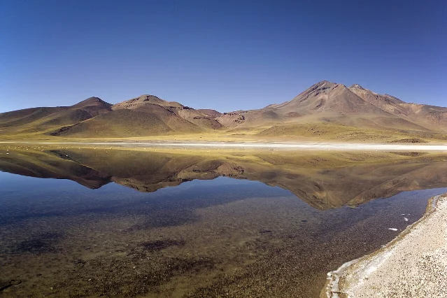
Laguna Miscanti lies in the Central Andes of northern Chile's Antofagasta Region, southeast of the Salar de Atacama. The nearest town is Socaire, about 20 kilometres away; San Pedro de Atacama lies about 90 kilometres away. A road from the Paso Sico international route reaches the lake, where footpaths lead through the reserve. 2
| Question | Answer |
|---|---|
| What kind of lake is it? | A clear, brackish lake in the Atacama Altiplano. 2 |
| How high is it? | About 4,140 metres above sea level. 2 |
| How large is it? | About 13 square kilometres, with measurements varying between 12.27 and 13.21 square kilometres as weather changes. 2 |
| What shape does it have? | An arrowhead, with a peninsula projecting from the northern shore. 2 |
| How deep is it? | About 10 metres at its deepest point. 2 |
| What is beside it? | Laguna Miñiques lies about 1.5 kilometres south, roughly 10 metres lower, separated by a lava flow and a low ridge. 2 |
A lake fed from below
The lake's most important plumbing runs underground. Springs provide the visible connections, while water from the Cordon de Puntas Negras mountains reaches Miscanti through groundwater. That hidden supply helps the lake persist throughout the year. Researchers have also described the role of local climate in that persistence as less certain, so the lake's survival cannot be reduced to one simple source. 2
Most water leaves through evaporation. Some groundwater moves south into Laguna Miñiques and may continue toward the Salar de Atacama. That underground movement carries away enough salt to keep Miscanti from becoming a salt pan, even though the water remains brackish. The lake's chemistry comes from a balance between water entering through rock and water leaving into air and neighbouring basins. 2
The floor records that balance. Muddy, banded sediments contain the remains of charophytes and diatoms, salts such as aragonite, calcite, dolomite, gypsum, and opal, together with volcanic tephra. A lava flow divides the otherwise flat lake bottom into two basins, while the floor drops steeply in the west and more gently toward the east and south. 2
The name carries an older human layer. Miscanti comes from Kunza, a language formerly spoken around the Salar de Atacama and Loa River valley, and means "toad." The source also records Miskanti and Miscanter as alternate forms, with a linguistic dispute over whether Miscanter is the original Kunza name and Miscanti a Quechua form. 2
Shorelines older than the view
The present lake occupies only part of the basin that water once covered. During a former highstand, Laguna Miscanti reached about 38.2 square kilometres, more than twice its current area, and stood roughly 29 metres higher. The larger lake may have joined Laguna Miñiques or formed part of a chain of connected lakes. At its highest stages, water overflowed toward the Pampa Varela basin. 2
The old water left evidence on land. Beach terraces, wave-cut platforms, alluvial fans, and sediments now sit around the basin. Former shorelines approach one kilometre from the modern water's edge. A sediment core can therefore turn an apparently empty strip of ground into a measurement of a former lake level. Sediments accumulated at roughly one millimetre per year and reach six to ten metres in some cores. 2
The older lake also supported more life. Algal bioherms and stromatolites grew in the water and along the shore. Fossils preserve green algae and Ranunculus plants, while the sediment sequence records repeated changes in water level and habitat. These remains give palaeoclimatologists a way to read past moisture from a place that now appears exceptionally dry. 2
The chronology is a sequence of wet and dry intervals rather than a single rise and fall. Tectonic and volcanic activity probably formed the basin about 22,000 years ago. Colder, drier conditions during the Last Glacial Maximum dried the lake between about 22,000 and 14,000 years ago. Later, the wetter Central Andean Pluvial Events brought more moisture to the Atacama and raised lake levels across the region. 2
The Holocene then brought a warmer, drier climate. Water levels fell by about 10 metres, and Miscanti may have become a bog or mudflat surrounded by wetlands. The exact timing varies by site, and radiocarbon dating creates uncertainty in parts of the regional chronology. Short wet periods and occasional floods also interrupted the long dry interval. 2
The lake reformed about 3,600 years ago and has persisted since then. Human resettlement around Miscanti followed about 3,400 years ago. More recent changes include a dry period beginning around 1650 and ending sometime between 1850 and 1920. Water levels stayed approximately stable from 1980 to 2000, declined until about 2015, and then began another upward trend. 2
The fault beneath the basin
Climate explains much of the lake's changing volume, while geology explains why water collects in this particular place. The 320-square-kilometre catchment contains volcanic and sedimentary rocks from the Miocene through the Holocene, along with volcanoes rising between 5,000 and 6,000 metres. Cerro Miscanti reaches 5,622 metres, and Cerro Miñiques reaches 5,910 metres. 2
The lake basin sits near the Quebrada Nacimiento fault, a structure about 100 kilometres long. The fault's activity helped form the basins occupied by Laguna Lejia, Laguna Miscanti, and Laguna Miñiques. Groundwater moves into and out of Miscanti along the fault, linking the lake's visible shoreline to the deep structure of the Andes. The region's volcanoes belong to the Andean Volcanic Belt, where the Nazca Plate dives beneath the South American Plate. 2
The landscape therefore holds two clocks. Tectonic movement and lava flows work over geological time. Rainfall, evaporation, and groundwater alter the lake over years or centuries. The old shorelines record the slower result of those processes, while the lake's changing level records their continuing interaction. 2
Life at the edge of high altitude
The water supports a small but connected food web. Meadows of Chara globularis cover much of the lake floor, alongside Myriophyllum and other charophytes. Amphipods, branchiopods, cladocerans, copepods, ostracods, bacteria, and ciliates live in the water or among the sediments. The copepod Boeckella poopoensis is the main crustacean recorded in the lake, while the presence of some daphnids remains uncertain. 2
The shoreline plants form a second zone. Meadows contain Fabiana, Festuca, Ruppia, and Stipa chrysophylla. The surrounding tolar vegetation includes grasses, shrubs, perennial herbs, Baccharis, ichu, and yareta. Above about 4,250 metres, vegetation gives way to high-altitude desert. 2
Laguna Miscanti and Laguna Miñiques are breeding sites for three flamingos: the Chilean flamingo, the Andean flamingo, and James's flamingo. Horned coots also breed there. Andean geese, giant coots, puna plovers, vicuñas, guanacos, southern viscachas, culpeos, and the Andean mountain cat belong to the wider community recorded around the lakes. 2
The source's list of species matters because the lake is more than a scenic surface. Plants stabilize a shallow lake floor, small crustaceans support larger animals, and the water's chemistry sets the terms for every species that uses it. A change in groundwater or lake level reaches the food web through those physical connections. 2
A protected place with competing uses
People used the basin long before visitors arrived for the view. The Miscanti-1 archaeological site sits on a beach terrace at the southeastern end of the lake. Animal remains, hearths, and stone tools lie beneath volcanic ash. The site was used during the dry middle Holocene, when hunter-gatherers hunted and ate mainly guanacos and vicuñas, along with birds and rodents. 2
Other sites, including Tulan-99, petroglyphs, and traces along prehistoric paths, point to seasonal or periodic use of the area. Climate shaped those movements. Wetter periods made more of the region habitable, while wetlands around Miscanti kept this high basin useful during a middle-Holocene drought. The lake's dry phase therefore changed human possibilities without making the area uniformly empty. 2
Today, tourism and conservation share the basin. Laguna Miscanti and Laguna Miñiques form part of Los Flamencos National Reserve. The lakes drew about 5,000 visitors in 2002 and about 75,000 in 2015. Visitors pay for access and must remain on the footpaths around the lake. The reserve has been jointly administered by the Socaire community and Chile's National Forest Corporation since 2003. 2
Water use creates a harder question. Since about 1997, the town of Peine has drawn its supply from the Chakizoke spring in the Miscanti basin. Mining companies' water use has caused disputes across the region. In 2007, the Pampa Colorada project proposed drawing water from the Miscanti watershed; local protests and environmental intervention followed, and the project was eventually halted. 2
The conflict joins the lake's major themes. Groundwater makes the lake appear stable, yet groundwater is also a resource that towns and industries can claim. A protected landscape can support tourism, science, grazing, spiritual practice, and wildlife at the same time. Those uses occupy one basin whose water moves through rock before it reaches the surface. 2
Five details worth remembering
- The lake sits at about 4,140 metres. Laguna Miscanti occupies an Andean basin in the Antofagasta Region, where cold nights, intense sun, and thin high-altitude air shape the environment. 2
- Its present area is only part of its former reach. The palaeolake covered about 38.2 square kilometres and stood roughly 29 metres higher, leaving shorelines almost a kilometre from today's water. 2
- The lake is wetter underground than it looks on the surface. Groundwater from the surrounding mountains supplies most of the water, while evaporation removes most of it. Underground drainage toward Miñiques helps carry away salts. 2
- The name means "toad." The word comes from Kunza, and alternate forms preserve a dispute over how the lake's name moved between Kunza and Quechua. 2
- The lake is both habitat and evidence. Flamingos breed there, while sediments, fossils, terraces, hearths, and stone tools record environmental change and human use across thousands of years. 2
Lines worth keeping
The source gives the lake a compact name in Kunza: "toad." 2
The article also preserves the phrase "archaeological silence" for the widespread abandonment of regional sites during a drought, while noting that Laguna Miscanti itself remained inhabited. The phrase is memorable because the evidence is uneven: a quiet record at one site can coexist with continued life at another. 2
Laguna Miscanti looks like a blue shape held still between volcanoes. Its history says otherwise. The lake has changed with rainfall, evaporation, faults, lava, groundwater, animals, travellers, and the people who depend on the springs beneath it. The view is calm because the movement has been pushed below the surface and into the ground beneath the shore. 2
Fuentes de referencia
- 1Wikipedia: Today's featured article/September 2, 2026
en.wikipedia.org
- 2Laguna Miscanti - Wikipedia
en.wikipedia.org
Este contenido lo produjo un canal automáticamente. Con una sola frase, Neodrop puede seguir produciendo para ti.
Contenido relacionado
More from this channel
- 4:07 p.m. in Buffalo: the handshake that changed presidential protection
- 1923's second season: the ending that needed eight more episodes
- Heard Island: the remote volcano where distance is no longer protection
- The beetle that spends two years in a log and two weeks in the light
- The ground Everton left, and Liverpool kept: how Anfield grew without moving
- Dreamlover, Hero, 30 million copies: how Music Box became Mariah Carey's bestseller
- 66 matches, 5–4, and Ipswich Town's one European trophy
- One World, Two Principles: How Dualism Splits Mind, Matter, and Reality