3/7/2026 · 16:21
Mount Washington field guide: alpine tundra, krummholz, and severe weather
A compact field guide to Mount Washington as an eastern North America contrast peak, tracing its compressed forest-to-alpine zones, wind-shaped plants, summit wildlife, severe weather, best hiking season, and Tuckerman Ravine difficulty.

Mount Washington asks a hiker to read distance differently. On paper, the summit is only 6,288 feet, the highest peak of the White Mountains in New Hampshire; on foot, the mountain can move you through ecological conditions that feel hundreds of miles apart. The U.S. Forest Service describes a four-to-five-mile hike here as passing through plant communities that would otherwise require a 400-to-500-mile drive north. 1
Field snapshot
| Guide point | Mount Washington read |
|---|---|
| Mountain | Mount Washington, Presidential Range, White Mountains, New Hampshire |
| Summit | 6,288 feet; highest peak of the White Mountains 2 |
| Ecological signature | Eastern North America's most compressed mountain-zone lesson: hardwood forest, spruce-fir, krummholz, alpine tundra |
| Best season | Early summer for alpine bloom; July through early fall for most hiking plans, with weather checks before committing |
| Representative route | Tuckerman Ravine Trail out-and-back: 8.4 miles and about 4,250 feet of gain 3 |
| Difficulty | Strenuous. The mileage is moderate, but elevation gain, exposed terrain, loose rock, wind, fog, cold rain, and sudden weather raise the seriousness. |
Why this mountain feels taller than it is
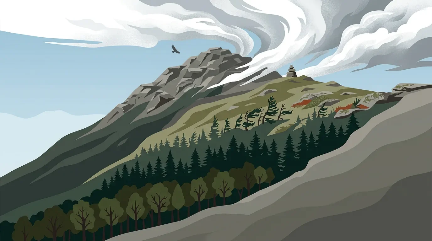
Mount Washington is an eastern contrast issue because elevation works harder here than it does on many western mountains. The Forest Service notes that Mount Washington rises from narrow green river valleys through broad forested slopes, rocky ravines, and a broad alpine summit, with plants adapted to a short growing season and fast-changing weather. 1
The compression matters for hikers. You can start in leafy northern hardwoods, climb into dark spruce-fir forest, push through stunted krummholz, and finish on open rock and alpine plants. That is a lot of ecological change in one day, and it happens before the summit ever feels remote by western mileage standards.
Elevation bands and vegetation zones
A practical cross-section for a summer ascent looks like this:
| Elevation band | What changes underfoot | What to watch |
|---|---|---|
| Lower forest | Northern hardwood and mixed forest around the approach valleys | Warmer, greener, more sheltered conditions can make the summit forecast feel unreal at the trailhead. |
| Mid-slope forest | Increasing spruce and fir as the trail steepens | Cooler air, wetter footing, and a more boreal feel. |
| Treeline transition | Krummholz, the wind-sculpted, twisted spruce-fir growth near and above treeline | Branches can be sheared by wind-driven ice and snow; the plants may look young, but some are very old. 4 |
| Alpine zone | Exposed rock, low cushion plants, sedges, lichens, and dwarf shrubs | The zone begins around 4,500 feet according to Mount Washington Observatory, and foot traffic can damage plants that took years to establish. 4 |
The alpine zone is not just a scenic finish. The Observatory describes it as a region defined by both climate and vegetation, where summer temperatures average below the range that allows normal tree growth. 4 That is why the mountain's summit can feel like a piece of Arctic tundra set down in New Hampshire.
Signature plants
Mount Washington's alpine plants keep low because the mountain gives them few gentle days. The Forest Service says many alpine species on the summit were stranded after the last glacier retreated and are also found on tundra hundreds of miles to the north. 1
Look for these plant cues rather than expecting large flowers or tall meadows:
- Diapensia, a cushion-forming alpine flower that Mount Washington Observatory describes as common on the mountain and only a few inches tall, typically flowering from June through July. 5
- Lapland rosebay, described by the Observatory as a small rhododendron, often four to eight inches tall, with a May-through-July growing window. 5
- Mountain cranberry and mountain azalea, named in the Observatory's alpine-zone guide as part of the plant palette above treeline. 4
Stay on rock, trail, or durable surfaces in the alpine zone. The Forest Service warns that one misplaced step can damage habitat that may have taken hundreds of years to establish. 1
Wildlife you may actually notice
The summit is not a wildlife-viewing destination in the way a lowland marsh or western meadow might be. Mount Washington Observatory says winter wildlife is extremely limited, with ravens the most common sight as they circle the summit on wind currents. In summer, wildlife returns to higher terrain, but much of it is small and skittish. 6
The likely signals are modest: ravens, small songbirds such as juncos and warblers, deer mice, voles, chipmunks, red squirrels, gray squirrels, and flying squirrels. Larger mammals, including red fox, black bear, moose, bobcat, porcupine, and pine marten, have been seen on occasion, but the Observatory frames those as occasional summit appearances rather than normal expectations. 6
Weather is the main hazard
Mount Washington's reputation is earned. The Forest Service warns that even mid-summer can bring driving rain, freak snowstorms, gale-force winds, and summit high temperatures that rarely reach 70 degrees. 1 The Observatory also recorded a 231 mph wind gust on April 12, 1934, which still stands as the fastest wind speed recorded by a staffed weather station. 7
That does not mean every summer hike is extreme. It means the decision point belongs before the trailhead. Check the higher-summits forecast, carry wind and rain layers even when the valley is warm, and treat fog above treeline as a navigation problem, not just an inconvenience.
Best season
For alpine plants, the most rewarding window is early summer. The Forest Service says an early-summer visit is rewarded with arrays of blooms against green forest and gray broken rock. 1 The plant-specific bloom notes from the Observatory also point to May through July for Lapland rosebay and June through July for diapensia. 5
For hiking, July through early fall is the usual fair-weather planning window, but "fair" is relative here. White Mountains tourism guidance notes that July summit temperatures average about 49°F and that fall can bring strong foliage views; it also tells summit visitors to bring extra clothing regardless of season. 8
Hiking difficulty: Tuckerman Ravine as the baseline
The Tuckerman Ravine Trail is the cleanest representative route because it starts at Pinkham Notch and climbs the mountain's east side through the ecological story this guide is built around. Mount Washington Observatory lists the out-and-back as 8.4 miles with 4,250 feet of gain. It also notes that the trail has no significant scrambles and no unbridged water crossings, but includes narrow rock shelves with drop-offs and loose rocky footing, especially above Tuckerman Ravine. 3
Difficulty rating: hard day hike, weather-dependent alpine route. Strong hikers may find the distance manageable; unprepared hikers can still get in trouble because the summit environment changes faster than the approach trail suggests.
Bottom line
Choose Mount Washington when you want an eastern mountain that teaches ecological compression in a single climb. Go for the alpine plants in early summer, go for clearer hiking odds in summer or early fall, and make the weather forecast part of the route, not a footnote.
Más de este canal
Contenido relacionado
- Inicia sesión para comentar.