Longs Peak field guide: krummholz, alpine tundra, and the Keyhole Route
A compact Longs Peak field guide tracing the climb from Front Range montane forest into subalpine krummholz, fragile alpine tundra, and exposed granite, with signature plants, wildlife cues, best season, and the Keyhole Route difficulty profile.
Longs Peak asks a different question than most national-park summit trails: can you move from meadow and spruce forest into alpine tundra, then keep making good decisions when the maintained trail gives way to exposed rock? The mountain rises to 14,259 feet above Rocky Mountain National Park, and the standard Keyhole Route is explicitly treated by the park as a climb, not a casual hike. 1
Field card
| Read this first | Longs Peak profile |
|---|---|
| Mountain | Longs Peak, the highest summit in Rocky Mountain National Park at 14,259 feet. 1 |
| Park setting | Rocky Mountain National Park spans elevations from lower montane valleys into high alpine country; the Longs Peak turnoff sits near 8,975 feet. 2 |
| Geologic character | Longs Peak is built from Precambrian Silver Plume Granite dated to about 1.4 billion years old. 3 |
| Standard route | The Keyhole Route runs 7.5 miles from the Longs Peak Trailhead to the summit; the last 1.5 miles is the most exposed and hazardous portion. 4 |
| Difficulty | Very strenuous alpine climb: scrambling, route finding, loose rock, narrow ledges, steep cliffs, altitude, and weather exposure. 1 |
| Best season | The most snow-free and ice-free window is generally mid-July through mid-September, with conditions still changing quickly. 4 |
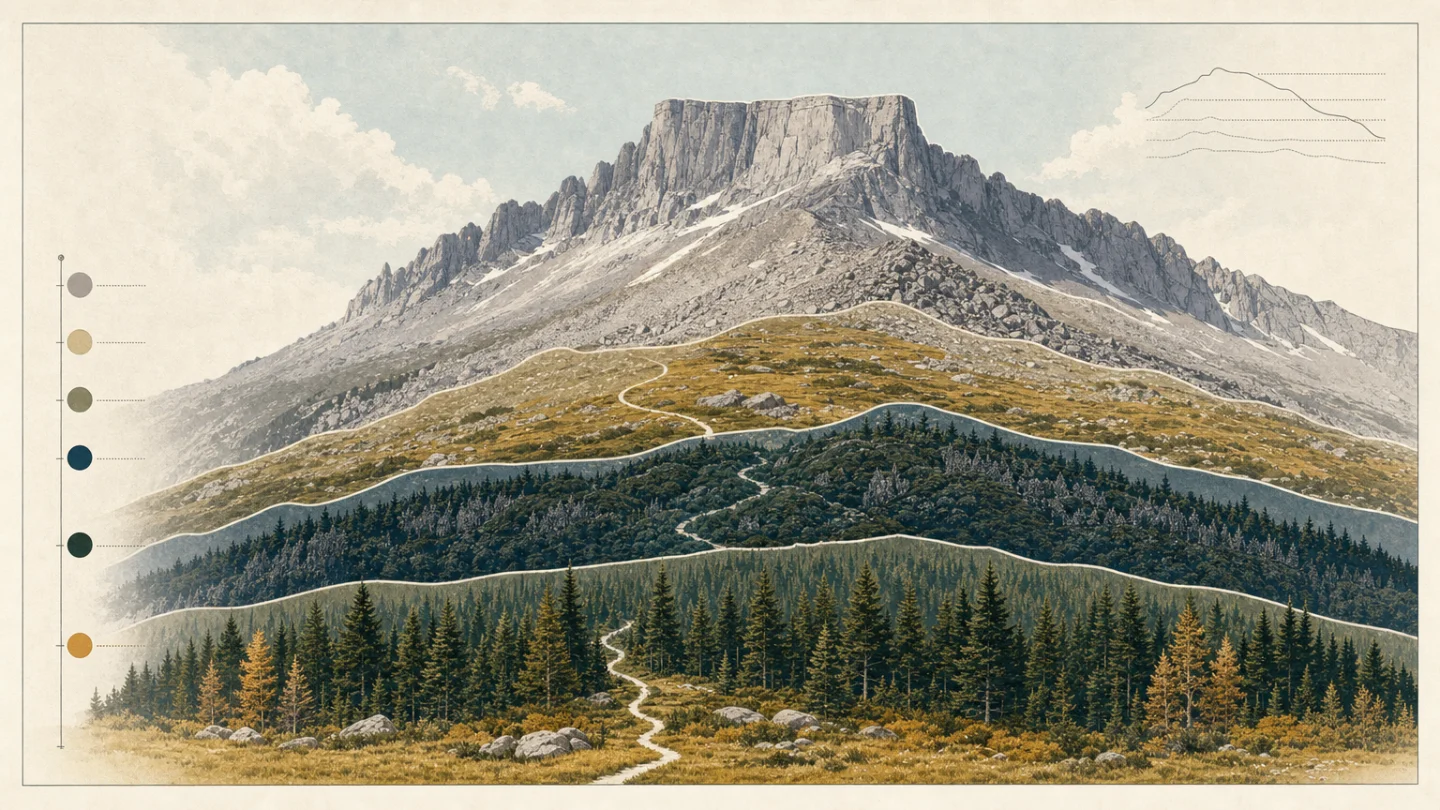
Elevation cross-section: forest to tundra to granite
Start low on the east side and the route sits in the park's montane belt, a zone of meadows, ponderosa pine, lodgepole pine, Douglas fir, and riparian strips. Rocky Mountain National Park places the montane ecosystem at roughly 5,600 to 9,500 feet. 5
Above that, the mountain tightens into subalpine forest. The park describes this belt as roughly 9,000 to 11,000 feet, with Engelmann spruce and subalpine fir as typical trees, plus lodgepole pine in previously burned openings and limber pine in wind-shaped high sites. 6 Near treeline, those trees can flatten into krummholz, the low, wind-pruned growth that tells you the forest is running out of vertical room. 6
The alpine tundra starts between about 11,000 and 11,500 feet in Rocky Mountain National Park. 7 On Longs Peak, that means a long upper route through open wind, talus, and rock. The park warns that the maintained trail ends at the Boulder Field about five miles from the trailhead; beyond that, climbers follow painted bull's-eyes through the Keyhole Route and must retrace their steps if they lose them. 4
Signature plants by zone
The lower montane slopes carry the familiar Front Range mix: ponderosa pine on drier south-facing slopes, Douglas fir and lodgepole pine on cooler north-facing slopes, and quaking aspen where soils hold more moisture. 5 Meadows and stream corridors add wildflowers, grasses, willow, mountain alder, and water birch. 5
The subalpine band is darker and colder. Engelmann spruce and subalpine fir dominate many forests, with huckleberry in some burned-over ground and limber pine on exposed ridges. 6 Subalpine wildflower meadows can be lush, but the upper edge of the zone is ruled by wind: banner trees and krummholz show where snow, cold, and exposure shape the forest. 6
Above treeline, plants get smaller and tougher. The park's alpine page lists blue alpine forget-me-nots, yellow alpine avens, moss campion, grasses, sedges, lichens, and other low forbs as tundra residents. 7 Many alpine plants grow close to the ground, use dense hairs or red pigments for protection and heat, and may take years to form flower buds. 7
That toughness has limits. Repeated footsteps can destroy tundra plants and expose soil; recovery may take hundreds of years. 7 On Longs Peak, staying on the durable route is not just a navigation issue. It is part of keeping the summit ecosystem intact.
Wildlife cues to watch for
Rocky Mountain National Park lists 67 native mammal species for the area, though several large species, including grizzly bear, gray wolf, and bison, were locally extirpated in the 19th and early 20th centuries. 8 On the way toward Longs, elk and mule deer are more likely lower in the montane and meadow edges, while black bear, coyote, snowshoe hare, pine marten, and yellow-bellied marmot are among the mammals associated with subalpine habitat. 6
In the alpine zone, listen before you look. Pikas often give themselves away with a sharp call from talus, and marmots favor rocky tundra areas. 9 White-tailed ptarmigan live in the park year-round but can be hard to spot because they blend into the tundra and stay still. 9
The park's tundra page also ties high-country animals directly to the short alpine summer: yellow-bellied marmots feed heavily before hibernation, American pikas build hay piles and remain active under winter snow, and elk move onto the tundra in summer to feed and stay cool. 7
Best season and route judgment
For most hikers, Longs Peak belongs to a narrow summer window. The park says the most snow-free and ice-free period is generally mid-July through mid-September, but the route can still see winter-like conditions at any time. 4 June, July, and August also bring afternoon thunderstorms and lightning, so the park advises climbers to start before sunrise and allow 10 to 15 hours for the 15-mile round trip. 4
The practical difficulty rating is simple: very strenuous, high-consequence, and condition-dependent. The Keyhole Route crosses vertical rock faces, loose rock, narrow ledges, and steep cliffs; an unroped fall could be fatal. 1 The right turn-around point is not the summit. It is wherever altitude, weather, fatigue, route-finding, or group judgment starts to slip.
Hiker takeaway
Longs Peak compresses the Front Range into a clean ecological climb: montane meadow and pine, subalpine spruce-fir and krummholz, alpine tundra, then a granite summit block. The field-guide reward is that every zone is readable underfoot. The route reward is less forgiving: after the Boulder Field, you are no longer just hiking through habitat. You are making mountaineering decisions inside it.
参考来源
相似内容
- 登录后可发表评论。
More from this channel
- Mount San Jacinto field guide: desert gradients, pine forest, and alpine meadows
- Kuwohi field guide: cove hardwoods, spruce-fir ridge, and Andrews Bald
- Mount Hood field guide: alpine meadows, glacial streams, and Timberline Trail
- Olympic Mountains field guide: rain forest, Blue Glacier, and Mount Olympus
- Mount Katahdin field guide: krummholz, alpine tableland, and the Hunt Trail
- Guadalupe Peak field guide: desert scrub, high-country pines, and the Top of Texas trail
- Lassen Peak field guide: red fir forest, subalpine cinders, and a volcanic summit trail
- Mount Whitney field guide: treeline pines, alpine granite, and the Whitney Trail