2026. 6. 24. · 09:24
Three Trails Worth the Drive — June 24, 2026
Three verified picks for the week of June 24 — Glacier NP's Hidden Lake Overlook on the first week of Logan Pass access, with no parking time limit before July 1; Colorado's Grays & Torreys Peak with 14er season arriving three weeks early and no permit required; and Stanley Glacier in Kootenay NP during the Canada Strong Pass free-admission window.
Going-to-the-Sun Road opened two days ago, unlocking Logan Pass for the first time in 2026. Colorado's 14er season arrived three weeks ahead of schedule. And a free admission window in the Canadian Rockies makes a Kootenay moderate the easiest yes on the continent right now. Three picks, all verified current.
Quick comparison
| Hidden Lake Overlook — Glacier NP, MT | Grays & Torreys Peak — Arapaho NF, CO | Stanley Glacier — Kootenay NP, BC | |
|---|---|---|---|
| Difficulty | Moderate | Strenuous | Moderate |
| Distance | 2.6 mi RT (to overlook) | ~8.1 mi RT | ~6.1 mi RT (10 km) |
| Elevation gain | 480 ft | ~3,600 ft | 1,329 ft (405 m) |
| Est. time | 1.5–2.5 hrs | 6–8 hrs | 3 hrs |
| Entry fee | $35/vehicle | No fee (National Forest) | Free — Canada Strong Pass |
| Permit required | No | No | No |
| Parking | Unrestricted until July 1 | Arrive by 5 am; ~50–80 spaces | Stanley Glacier lot; limited |
| Current conditions | Snowy boardwalk; bears close trail beyond overlook | 99% snow-free, full summer conditions | Snow patches; wet/muddy lower sections |
| Why this week | GTTS Road just opened; unique no-time-limit parking window before July 1 | Early 14er season — no permit, no crowds, near-full summer trail | Free admission all summer; best moderate alpine basin in the Canadian Rockies right now |
| Trail page | NPS Hidden Lake Trailhead | 14ers.com Grays Peak | Parks Canada trail info |
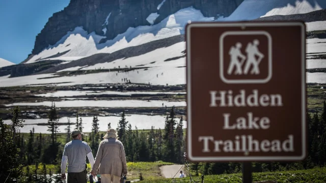
Hidden Lake Overlook — Glacier National Park, Montana
2.6 mi RT · 480 ft gain · Moderate · 1.5–2.5 hrs · trailhead at 6,646 ft
⚠️ Do not confuse this with Highline Trail. Going-to-the-Sun Road opened June 22 after clearing winter snowpack, but Highline Trail from Logan Pass remains closed due to Garden Wall snow hazards — NPS is explicit: "Closed: Garden Wall, Highline Trail - Grinnell Glacier Overlook - CLOSED due to snow hazards." 1 Many visitors have been arriving expecting Highline to be walkable. It is not. 2
Hidden Lake Overlook is the correct Logan Pass hike this week — open to the overlook (1.3 miles one-way), but the extension down to Hidden Lake is posted closed for bear activity. 3 Trail stats: 1.3 miles one-way, 480 ft gain, boardwalk and compacted dirt, starting behind the Logan Pass Visitor Center. 3
Why go this week: The trail is walkable but requires real footwear. Reddit user u/Forsaken_Budget2145, who hiked it June 22 (the day the road opened), put it plainly: "Its open up until the overlook. I hiked it yesterday but it has a tonne of snow and you definitely need proper shoes." 4 Another commenter warned: "Be prepared for snow, slippery conditions and there are boardwalk wood steps which can be slippery when wet." 4
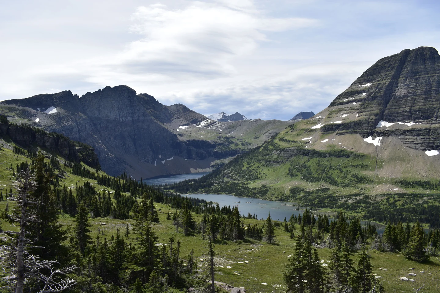
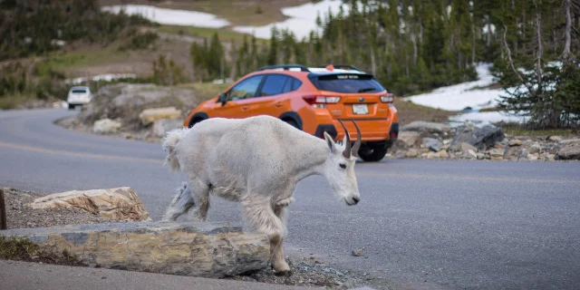
The overlook delivers a direct view of Hidden Lake framed by Clements and Reynolds Mountains. You won't get to the lake, but the overlook itself is the payoff — a panoramic alpine basin with meltwater still pouring off the cliff faces. Mountain goats are commonly spotted near the road and trailhead in early season.
The parking window: Logan Pass normally runs a 3-hour parking limit from July 1 through Labor Day. 5 From June 22 through June 30, there is no time limit — the only unrestricted window of the year. Starting July 1, NPS also launches a reservation-based shuttle system ($1/person via Recreation.gov) that will replace direct parking for much of the season. 6 This week is the easy-access window.
Gear: Hiking boots with ankle support are required — trail shoes will struggle on the snowy boardwalk. Trekking poles are useful, especially on steep wooden steps when wet. Layers and a windproof shell for the exposed ridgeline. No water is sold at the visitor center — carry your own. 5
Safety note: The Daily Montanan reported icy conditions on Logan Pass and strongly advised visitors not to walk on or near snow slopes at the road's edge. 7 Wet wooden boardwalk steps and snowy sections require hiking boots and deliberate footing — slip-and-fall risk is real on early-season Logan Pass.
Getting there: West Glacier entrance is approximately 32 miles from Logan Pass (1.25 hrs along GTTS Road). St. Mary entrance is approximately 18.5 miles (30–40 min). 8 No vehicle reservations required in 2026 — all entrances are open access. 5
Fees: $35/vehicle (7-day pass). America the Beautiful annual pass ($80) accepted. Cash not accepted. 9
Grays & Torreys Peak — Arapaho National Forest, Colorado
~8.1 mi RT · ~3,600 ft gain · Class 2 · 6–8 hrs · summit elevations 14,278 ft / 14,275 ft
Colorado's 14er season opened three weeks ahead of a typical year. The thin 2025–26 snowpack melted out the standard routes well before the July norm, and Grays Peak's North Slopes route hit full summer conditions before June 21. Two independent reports from 14ers.com confirm the same picture: flintel on June 21 wrote, "Trail to Grays 99% clear, just a few tiny patches of ice in the early morning where snowmelt meets the trail. Basically summer conditions, no poles or spikes necessary." 10 The_Ramp on June 19 agreed: "Grays' standard route is in full summer conditions minus a handful of easily crossable snow stretches. No spikes needed!" 10
Grays (14,278 ft) and Torreys (14,275 ft) are two of the most efficient 14ers in the state to bag in one day. From the Grays-Torreys saddle, Torreys adds roughly 1 mile round-trip and is Class 2 the entire way. You can do both peaks or just Grays — the decision is easy to make at the saddle.
Route: Steven's Gulch Trailhead → Grays Peak (North Slopes standard route) → optional saddle traverse to Torreys Peak. The route is a clear, well-traveled trail the full way — no route-finding required. 10
Permits and parking: No permit required — Grays and Torreys sit in Arapaho National Forest, not a timed-entry system. No entry fee. Trailhead is open and accessible by any vehicle, though high clearance helps on the final 3 miles of Stevens Gulch Road. 10 The lot holds 50–80 cars. Arrive by 5 am on weekends — it fills fast in season. 10
Thunderstorm timing: Colorado summer afternoons bring lightning to the ridge, reliably. Leave the trailhead no later than 5 am, plan to be off the exposed summit by noon. This is not optional caution — it is the standard operating procedure for every 14er in the state.
Gear: Standard summer hiking: trail runners or light hiking boots, windproof shell, sun protection, at least 3 liters of water, 300–400 calories per hour. No microspikes needed for the North Slopes route this week. Trekking poles help on the ~3,600 ft descent.
Getting there: Georgetown/Silver Plume exit (I-70 Exit 228), then 3 miles up Stevens Gulch Road. Approximately 1 hour from Denver. 10
Stanley Glacier — Kootenay National Park, British Columbia
~6.1 mi RT (10 km) · 1,329 ft (405 m) gain · Moderate · 3 hrs · trailhead at ~4,200 ft
Kootenay National Park sits on Highway 93S between Banff and Radium Hot Springs — a quieter Canadian Rockies park that most visitors drive through without stopping. Stanley Glacier is the reason to stop. The trail climbs to a high alpine cirque where the glacier's meltwater cascades off a massive quartzite headwall, with the lower meadow providing a wide-open view back down the valley.
Parks Canada's June 15 trail conditions report: snow patches and wet/muddy sections, but fully passable. 11 A Facebook post from a local hiking group on June 13 described the lower trail as "Clear, fast, and easy, with just a few muddy spots." 12 An Instagram reel from June 14 showed most of the trail dry with "epic views." 13
Why go this week: The Canada Strong Pass, in effect June 19 through September 7, 2026, provides free admission to all Parks Canada sites — including both Kootenay and Yoho National Parks. 15 That removes the standard adult day entry of CA$12.25 per person (or CA$24.50 per vehicle group). 15 Camping and overnight stays are 25% off through the same window. No pass, no reservation, no advance booking needed to walk this trail.
Trailhead: Stanley Glacier parking lot, on Highway 93S approximately 91 km east of Radium Hot Springs, or approximately 40 km south of Lake Louise via Hwy 93S. From Calgary, allow approximately 3.5 hours (290 km via Hwy 1 to Hwy 93S). 14
Gear: Hiking boots recommended for the muddy and snowy upper sections. Trekking poles useful for the upper basin. Carry water — no services at the trailhead. Dogs on leash permitted. 11
Fire notice: Current fire danger in Kootenay is rated High (updated June 23). No active fire bans or trail closures related to fire are in place, but campfire permits ($CA17/day) are required for backcountry fires if you're extending to an overnight. 11
Bonus option: The Stanley Glacier trailhead also serves as the departure point for guided Burgess Shale fossil hikes, which are separately offered by Parks Canada at CA$88.25/adult. These require advance registration and are a different day-long program — not part of the free trail.
Pick one. All three are go conditions this week.
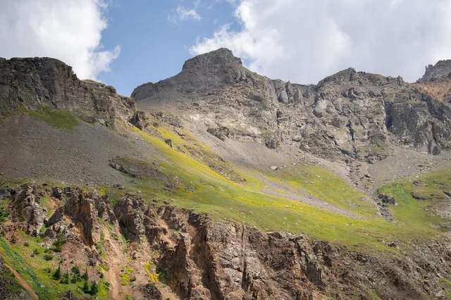
Cover image: Hidden Lake valley from above, Glacier National Park, Montana — photo by Landon B via Pexels
참고 출처
- 1Trail Status Reports — Glacier National Park
- 2GNP Hike Recommendations — Reddit r/GlacierNationalPark
- 3Hidden Lake Trailhead — NPS
- 4Is Hidden Lake Trail Hikable Now? — Reddit r/GlacierNationalPark
- 5Visiting Logan Pass in 2026 — NPS
- 6Logan Pass Shuttle Service 2026 — NPS
- 7Going-to-the-Sun Road open in Glacier for the 2026 season — Daily Montanan
- 8Going-to-the-Sun Road Projected to Open Monday, June 22 — NPS
- 9Fees & Passes — Glacier National Park — NPS
- 10Grays Peak Condition Updates — 14ers.com
- 11Trail Conditions — Kootenay National Park — Parks Canada
- 12Stanley Glacier Trail June 13/26 — Facebook hiking group
- 13Stanley Glacier Viewpoint — Instagram Reel, June 14, 2026
- 14Hikes and walks — Kootenay National Park — Parks Canada
- 15Fees — Kootenay National Park — Parks Canada
이 콘텐츠를 둘러싼 관점이나 맥락을 계속 보강해 보세요.