2026/7/3 · 16:06
Denali field guide: taiga, tundra, glaciers, and the West Buttress
A Denali field guide that follows the mountain from boreal taiga through tundra and glacier, with signature plants, wildlife, hiking season, and the difference between a steep park trail and a West Buttress expedition.

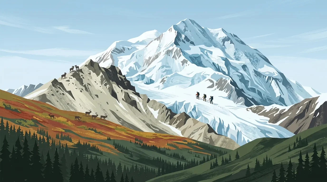
Denali does not climb like Mount Rainier and it does not read like a Cascades volcano. The mountain rises from interior Alaska's boreal lowlands into tundra, glacier, and a 20,310-foot summit, with a base-to-summit rise that USGS describes as about 18,000 feet, taller than Everest by that measure even though Everest reaches a higher absolute elevation. 1
For a field-guide reader, that vertical relief is the point. Denali is less a single trail objective than a stacked subarctic system: spruce and birch near the park road, shrub tundra above treeline, rare alpine plants on exposed ridges, and a glaciated upper mountain where weather and crevasses set the rules.
Field snapshot
| Field mark | Denali profile |
|---|---|
| Summit | 20,310 feet, the official height measured by USGS in 2015. 2 |
| Mountain system | The high point of the Alaska Range, built by active tectonic uplift along the Denali fault and reshaped by glaciers. 1 |
| Park context | Denali National Park and Preserve covers more than 6 million acres, with one road as the main visitor corridor. 3 |
| Ecosystem pattern | Lowland boreal forest gives way to subalpine scrub and alpine tundra in three broad elevation zones. 4 |
| Wildlife cue | The park is home to 39 mammal species, 169 bird species, and one amphibian species. 5 |
| Practical rating | Park hiking can be strenuous; the Mount Healy Overlook Trail gains 1,700 feet in 2.7 miles one-way and is one of Denali's steepest maintained trails. 6 Summit climbing is an advanced, multi-week expedition on crevassed glacier terrain. 7 |
Elevation bands: taiga to ice
Denali's plant zones are low in absolute elevation compared with the lower 48. Latitude does the work that height does farther south: cold, short growing seasons, permafrost, wind, and snowpack compress the ecological ladder.
| Band | Approximate elevation | What changes underfoot |
|---|---|---|
| Lowlands | Below 650 m / 2,133 ft | Boreal forest dominates, with black spruce on permafrost and white spruce with paper birch on better-drained uplands. Common plants include bog blueberry, green alder, resin birch, white spruce, black spruce, dwarf birch, tussock cottongrass, cloudberry, tealeaf willow, and marsh Labrador tea. 4 |
| Subalpine | 650 to 950 m / 2,132 to 3,117 ft | The forest breaks into a mosaic of scrub vegetation, spruce woodland, and meadows. Dwarf birch, bog blueberry, green alder, black crowberry, lingonberry, willows, sedges, and Labrador tea are common. 4 |
| Alpine | Above 950 m / 3,117 ft | Plant growth reaches its upper limit, yet NPS notes that this zone has Denali's highest plant diversity and many endemic or rare species. Mountain-avens, dwarf birch, willow, fescue, sedge, white arctic mountain heather, lingonberry, and tall bluebells appear in this band. 4 |
| Glaciated upper mountain | Above the vegetated alpine system | USGS describes Denali as one of the coldest mountains in the world because of its high elevation and far-northern position; the park has more than 400 glaciers, including the 44-mile Kahiltna Glacier. 1 |
The cleanest mental cross-section is spruce, shrub, tundra, ice. A hiker starting near the entrance area may begin in spruce and birch, climb through benches and switchbacks, and step above treeline into wind. A climbing team starts much higher, often flying to Kahiltna Glacier base camp at about 7,200 feet, then works upward through glacier camps rather than vegetation zones. 8
Signature plants to notice
The low country carries the boreal feel: black spruce, white spruce, paper birch, Labrador tea, cloudberry, tussock cottongrass, bog blueberry, and crowberry. These plants tell you that wet ground, permafrost, and cold air still matter even before the mountain fills the skyline. 4
Higher up, the visual palette shifts toward dwarf birch, willow, sedges, lingonberry, mountain-avens, and arctic heather. Fall makes the subalpine band especially legible, when dwarf birch turns red and orange across the hillsides. 4
Wildlife: watch the habitat, not just the road
Denali was first created to protect wildlife, especially Dall sheep, and NPS still frames wildlife viewing as one of the park's main visitor draws. 3 The large-mammal cast is compact and memorable: moose browse willow, caribou move across tundra, Dall sheep hold high hillsides, wolves travel wide, and grizzly bears feed in berry country. 9
Smaller mammals make the alpine and talus zones feel alive if you slow down. NPS points to collared pika, hoary marmot, red fox, arctic ground squirrel, snowshoe hare, wolverine, voles, and shrews as part of the mammal community. 9 For birders, summer is the richer window: the wildlife overview notes more than 160 bird species in summer, with far fewer remaining through winter. 5
Best season: choose the mountain you mean
For general park travel, the main visitor season runs from May 20 through the second or third week of September. That is when the park road and bus system shape most visits; the road is the main way visitors see the park, and private vehicles are generally limited to the first 15 paved miles in summer. 3
For hiking, late June through early September is usually the most practical field-guide window: trails and road access are active, alpine plants are visible, wildlife viewing is strong, and fall color starts to show before services taper. Shoulder seasons can be quiet and beautiful, but NPS warns that fall and spring visits come with limited services. 3
For climbers, the calendar is different. NPS says the typical Denali climbing season starts in late April and continues through mid-July. May is colder and windier; June and July tend to be milder but can bring more snowfall. By late July, lower-glacier travel gets harder as snow bridges over crevasses melt. 8
Difficulty: park hike versus summit expedition
If you want a strenuous nontechnical park route, Mount Healy Overlook is the clean benchmark. It is 2.7 miles one-way, gains 1,700 feet, climbs from spruce forest toward treeline, and gets steep enough near the top that NPS calls it one of Denali's steepest trails. The official trail does not reach Mount Healy's true summit; continuing along the ridge is permitted but can be dangerous, and NPS notes that people have died in falls there. 6
The summit is a different category. NPS describes Denali as a serious expedition that usually takes multiple weeks, requires glacier travel, route finding, crevasse rescue, winter-camping experience, and altitude judgment. The West Buttress is the least technical and most common route, but it still involves extensive crevassed glacier travel, snow and ice climbing up to about 40 degrees, fixed lines above the 14,200-foot camp, and exposed terrain near Denali Pass. 7
A practical rating:
- Mount Healy Overlook: strenuous day hike; steep maintained trail, 1,700 feet of gain, wind exposure near the overlook.
- West Buttress: advanced expedition mountaineering; lower technical grade than Denali's harder routes, but high objective hazard, cold, altitude, glacier travel, and rescue limits.
- Casual park visit: moderate if you stay near road-accessible stops; harder if you leave maintained trails, because much of Denali is trail-less wilderness.
Field guide verdict
Denali is the right issue after Rainier because it changes the whole ecological grammar. Rainier moves from temperate conifer forest to subalpine meadow and volcanic ice. Denali moves from subarctic taiga to tundra and a colder, larger glacier world. Read it by zones, keep the season separate from the climbing calendar, and do not let the phrase "least technical" make the West Buttress sound casual.
このチャンネルのその他のコンテンツ
関連コンテンツ
- ログインするとコメントできます。