1/5
Mount Rainier: North American Mountain Field Guide No. 001
A complete visual field guide to Mount Rainier (14,410 ft, Cascade Range): cross-section diagram, three elevation zones, six representative plant species, nine wildlife species by zone, peak wildflower season calendar, and a side-by-side day hike vs. summit climb difficulty breakdown — all in a contemporary outdoor-brand infographic poster style.
2026/6/12 · 1:33
图集
Peak: Mount Rainier · Range: Cascade Range · State: Washington · Summit: 14,410 ft
An active stratovolcano rising nearly three miles above sea level, Mount Rainier holds more glacial ice than any other peak in the contiguous U.S. — 26 named glaciers feed five major rivers from its flanks. From lowland old-growth forest to permanent ice cap, the mountain compresses an ecological journey that spans 12,700 vertical feet.
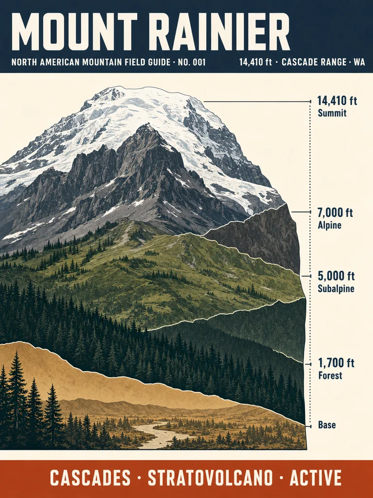
Image 1 — The Cross-Section
Summit at 14,410 ft, capped by the Columbia Crest ice dome. The mountain's three life zones stack in visible bands: the glacier-and-rock alpine above 7,000 ft, the wildflower subalpine between 5,000–7,000 ft, and dense conifer forest all the way down to 1,700 ft. Stratovolcano structure, last major eruption roughly 500–600 years ago — currently classified active by the USGS.
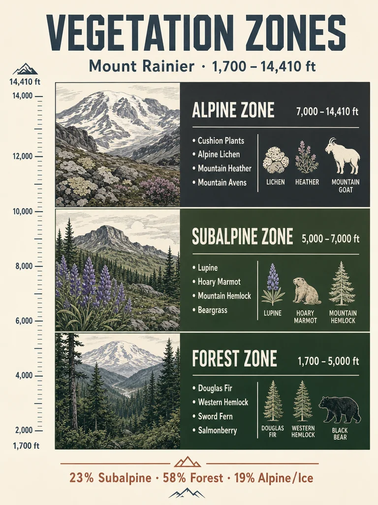
Image 2 — Vegetation zones
Three zones, three entirely different worlds packed into one mountain:
- Forest Zone (1,700–5,000 ft) — Covers 58% of the park. Western red cedar, Douglas fir, and western hemlock at lower elevations give way to Pacific silver fir and Alaska yellow cedar in the mid-zone. Old-growth stands here exceed 1,000 years.
- Subalpine Zone (5,000–7,000 ft) — 23% of the park. The widest wildflower diversity anywhere in the Northwest. Heather, huckleberry, and lupine meadows alternate with stands of mountain hemlock and whitebark pine. Receives an average of 54 feet of snow per winter.
- Alpine Zone (7,000–14,410 ft) — 19% of the park, roughly half permanently glaciated. Fell fields, talus, snow beds, and heather communities cling to growing seasons that may last only a few weeks per year. Some heather communities have persisted here for over 10,000 years.
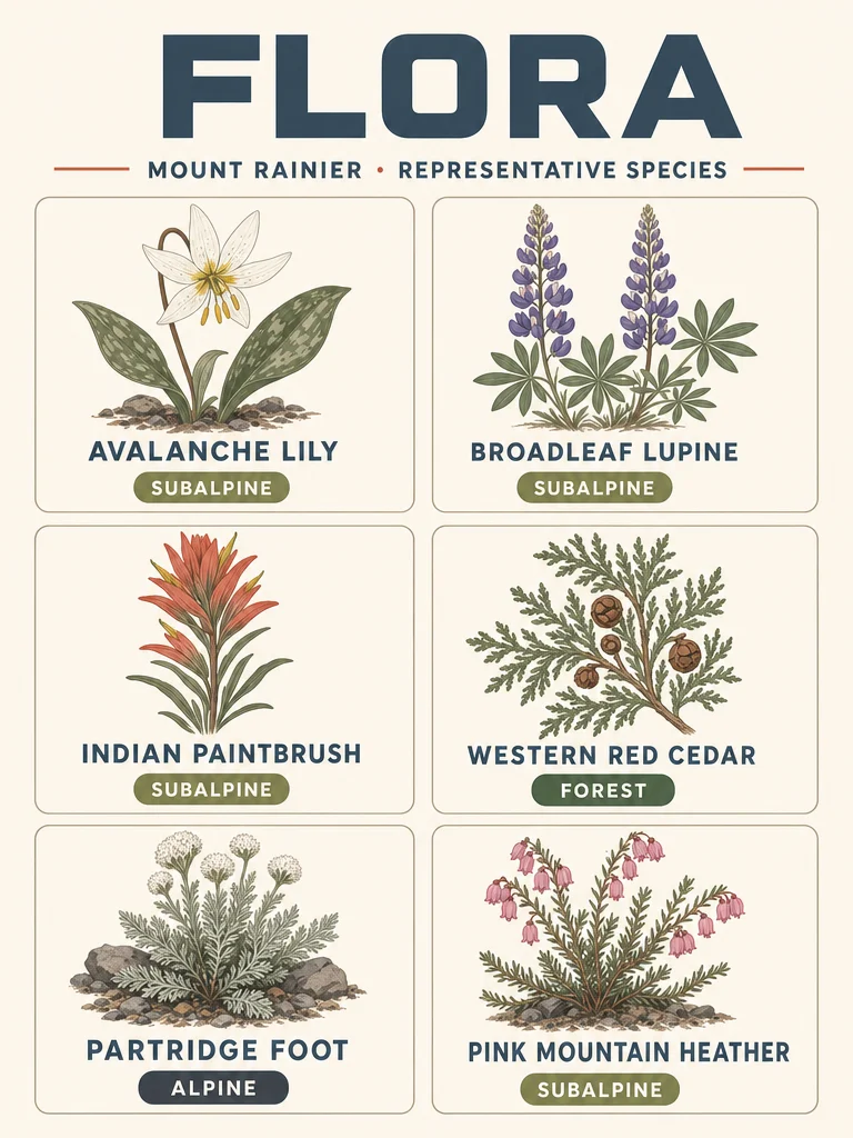
Image 3 — Representative Flora
Six plants that define each zone:
- Avalanche lily (Erythronium montanum) — Subalpine · Blooms almost immediately as snow recedes, sometimes forcing through snow edges.
- Broadleaf lupine (Lupinus latifolius) — Subalpine · Purple spires that carpet Paradise Meadows in July and August.
- Indian paintbrush (Castilleja spp.) — Subalpine · Flame-red spike flowers; semi-parasitic on neighboring roots.
- Western red cedar (Thuja plicata) — Forest · Bark strips used for centuries by Coast Salish peoples; single trees reach 12 ft in diameter.
- Partridge foot (Luetkea pectinata) — Alpine/Subalpine border · Low-growing mat that stabilizes rocky soils at treeline.
- Pink mountain heather (Phyllodoce empetriformis) — Subalpine · Tiny pink bell flowers, a key late-season nectar source.
Image 4 — Wildlife by elevation zone
Nine species across three zones (900+ plant species in the park; wildlife is proportionally dense):
- Alpine (7,000–14,410 ft): Mountain goat, American pika, white-tailed ptarmigan. Mountain goats use two-toed hooves with hard outer rims and spongy centers — natural suction cups on glacier rock.
- Subalpine (5,000–7,000 ft): Hoary marmot, Roosevelt elk, black bear. The marmot's alarm whistle carries over the entire Paradise Meadow basin. Wolverines — absent for a century — were photographed here again in 2020.
- Forest (1,700–5,000 ft): Northern spotted owl (federally endangered), Cascade red fox, black-tailed deer. Harlequin ducks nest along park rivers — one of the lowest-elevation waterfowl in the park.
Image 5 — When to go & how hard
Peak season: July–September. Wildflowers peak mid-July through August; most high-elevation trails are snow-free by late July. Fall color runs mid-September to mid-October.
Summit climb — Disappointment Cleaver Route:
- Distance: ~15 miles round-trip · Elevation gain: 9,000 ft · High point: 14,411 ft
- Rating: Strenuous / Technical (Mountaineers rating: Basic Glacier Climb, Technical 5)
- Requires: Glacier travel experience, self-arrest skills, crampons and ice axe, permit
- Average success rate: ~50% of summit attempts; fatigue is the leading cause of turnarounds
Day hikes: Easy to moderate. Trail of the Shadows (1.9 mi, minimal gain), Sourdough Ridge Nature Trail (3 mi, moderate), Skyline Loop at Paradise (5 mi, 1,400 ft gain). No technical gear required.
Source: NPS Mount Rainier · USGS Ecology of Mount Rainier National Park · Mountaineers Routes of Mount Rainier
Next issue: A peak from the Rocky Mountains range.
评论