Three Trails Worth the Drive This Week — May 11–17
Three trail picks for May 11–17 where timing matters most: a rare lupine superbloom in Redwood NP's Bald Hills, The Narrows at Zion near historic low flow (45 CFS), and Johnston Canyon in Banff during the car-free shoulder-season window with snowmelt waterfalls at peak.
This week hands hikers a rare alignment: a wildflower event that follows a specific fire timeline, a canyon river running at near-record low flow, and a Canadian national park trail that's temporarily car-free. All three windows are open right now and will close — some within days.
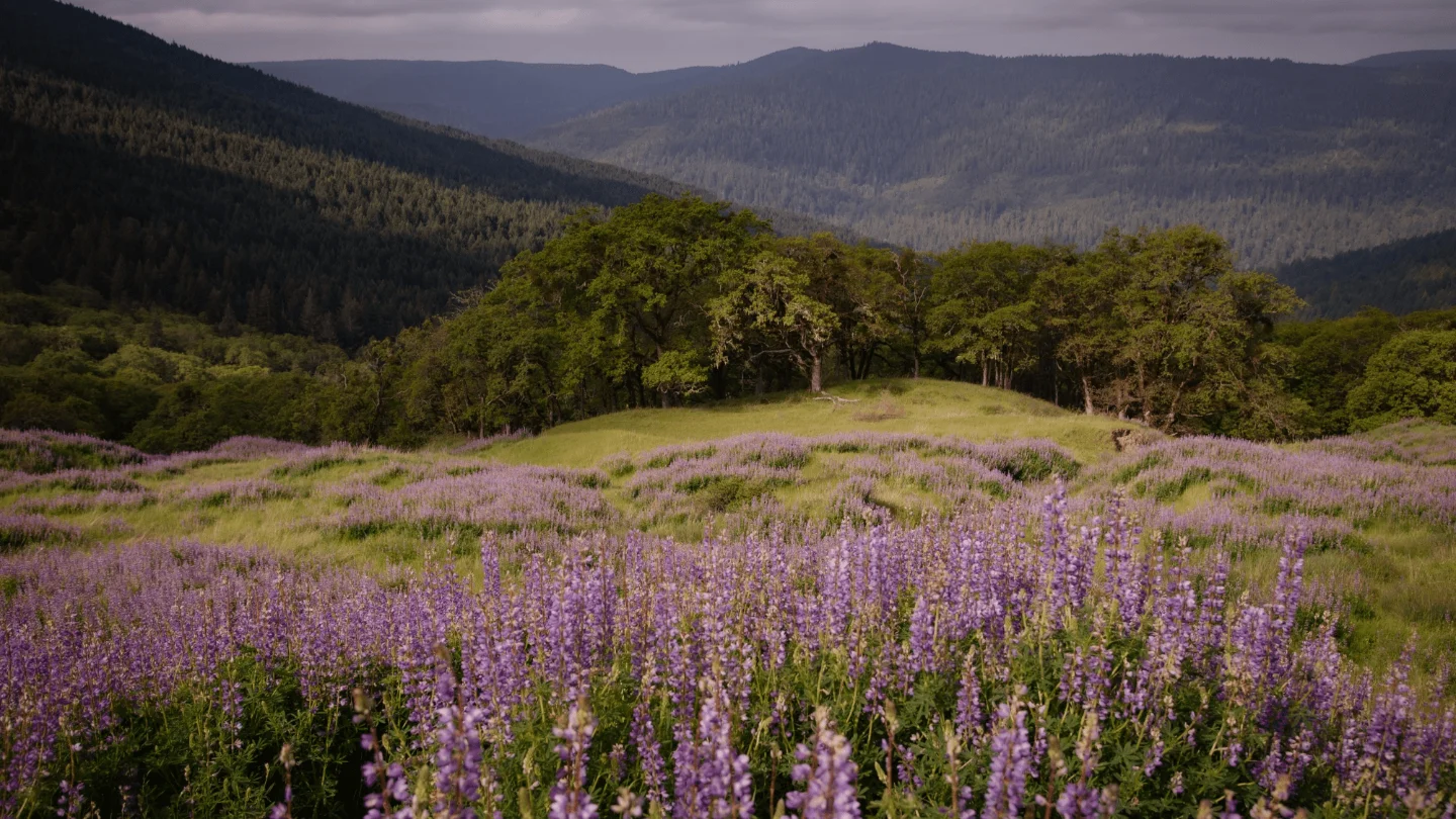
Bald Hills, Redwood National and State Parks, California

The Bald Hills inside Redwood National and State Parks are covered in purple right now — a riverbank lupine (Lupinus rivularis) superbloom that erupted in early May 2026 and is expected to last through the end of the month. 1
This specific bloom happens on a predictable ecological schedule: one year after a prescribed burn, lupine plants regenerate vegetatively; two years post-burn, they flower en masse. The NPS describes the dynamic directly — "one year after a fire, we end up with a lot of vegetative lupines, but two years post-burn, just like the burn that they did in this drainage two years ago, we end up with a lupine superbloom." 2 The last comparable events in this area occurred in 2009 and 2025. 3 NPS officials note the flowers are fragrant and ecologically active: "These blooms are delicate, and we want to make sure all visitors can enjoy them, including one of the lupine's favorite visitors: pollinators!" 4
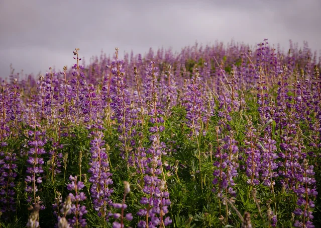
Trail character: There is no designated trail system on the flowered hillsides — visitors walk along existing elk and deer paths through open coastal-prairie grassland backed by redwood forest. The terrain is easy, with minimal elevation gain on the open slopes. 2
Getting there:
- From San Francisco: approximately 6 hours north via US-101
- From Crescent City: approximately 45 minutes south on US-101, then turn onto Bald Hills Road north of Orick, CA, and drive roughly 18 miles east past Lady Bird Johnson Grove to the Lyons Ranch Trailhead at the end of the road 1
Parking and access: Limited pullouts along Bald Hills Road; no large formal parking area. Bald Hills Road is open but has hazard conditions — drive slowly and watch for road damage. 1
Fees and permits: Standard National Park entrance fee — $35/vehicle for a 7-day pass, or free with an America the Beautiful annual pass. No additional permit is required for the Bald Hills area or Lyons Ranch Trailhead. (Note: Fern Canyon, a separate area of the park, requires a reservation May 15–September 15.) 1
Go prepared: No water, no restrooms, and no cell service in the Bald Hills. Bring a full tank of gas, food, and water before leaving Orick.
The Narrows (bottom-up), Zion National Park, Utah
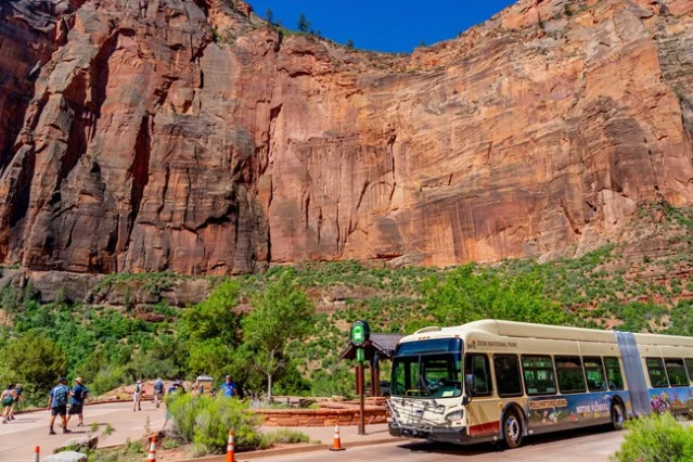
Image from: Zion Canyon Shuttle System
The Virgin River's North Fork was flowing at 45 CFS (cubic feet per second) on the morning of May 17, 2026, according to USGS gauge data. 5 The median flow for this date is 145 CFS — more than three times the current reading. The 37-year record minimum for this date is 28 CFS (set in 2002), and the current reading sits well below the median — among the lowest flows on record for mid-May. The Narrows closes automatically when flow reaches 150 CFS; at 45 CFS, it is wide open.
The NPS describes what 45 CFS means on the trail: "When the river is running below 70 cubic feet per second (CFS), walking is moderately difficult, with knee deep crossings on the slippery and uneven river bottom with frequent pools up to waist deep." 6 In practical terms — this is about as accessible as The Narrows gets in May. Snowmelt surges that typically push flow above walkable levels by mid-month simply haven't arrived yet.
Trail character: Strenuous — wading in moving water on slippery, uneven rock. The bottom-up route from Temple of Sinawava starts with a 1-mile paved Riverside Walk, then becomes a full river walk. Distance is variable; most day hikers turn around anywhere between 2 and 5 miles in, with Big Spring at roughly 5 miles one-way representing a full-day turnaround.
Getting there: The Narrows starts at Temple of Sinawava (Shuttle Stop 9). The Zion Canyon Shuttle (free, no ticket required) runs from 7:00 AM; the last shuttle leaves the Temple of Sinawava at 7:15 PM on May 17. 7
Parking: The Visitor Center lot fills by 8–9 AM. Overflow parking in Springdale runs $20–30/day; the Springdale Line shuttle connects town to the park entrance. 6
Fees and permits: Park entrance fee is $35/vehicle. The bottom-up day hike to Big Spring requires no wilderness permit. (The 16-mile top-down through-hike from Chamberlain's Ranch requires an advance wilderness permit.)
Gear: Closed-toe shoes are essential. Water temperature on May 17 was 13.3°C (56°F) — cold enough to warrant neoprene socks and a hiking pole for balance. 5 A wetsuit or dry suit is worth bringing for anyone planning to stay in the water for several hours.
Two hazards to know: Toxic cyanobacteria has been detected in the Virgin River — do not submerge your head or drink river water. Flash floods can develop without warning; the canyon closes automatically when a Flash Flood Warning is issued for the area. Check weather.gov before heading in. 6
Johnston Canyon (Lower + Upper Falls), Banff National Park, Alberta
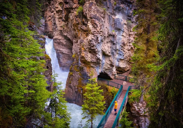
Johnston Canyon sits in a narrow limestone slot canyon about 25 km west of the Banff townsite, and May is when it hits its peak. Natasha and Cameron of The Banff Blog, who live locally and have hiked the trail across every season, put it directly: "My favorite time to hike to Johnston Canyon is in May and June, when the snowmelt is high, creating heavy water flow from the waterfalls." 8 The same source notes that between June and September, "expect the trail to be extremely crowded." 9 Early-to-mid May is the window before that crowd pattern takes hold.
This year there's an additional reason to go now: the Bow Valley Parkway — the main road running past the Johnston Canyon parking lot — has vehicle access restricted from 8:00 AM to 8:00 PM daily through June 25, as Parks Canada manages wildlife activity along the corridor. 9 The practical effect is a quieter trail: the typical summer stream of cars along the parkway isn't there. Hikers arriving by bicycle (the parkway becomes a car-free cycling road during those hours) or by driving around via Castle Junction off the Trans-Canada Highway access a canyon that is unusually peaceful for a trail of this popularity.
Trail character: Easy. Elevated catwalks are bolted into the limestone walls, making the route accessible even for families with young children. Two destinations:
| Destination | Distance (RT) | Elevation gain | Estimated time |
|---|---|---|---|
| Lower Falls | 2.3 km (1.4 mi) | 105 m (344 ft) | ~1 hour |
| Upper Falls | 5.5 km (3.4 mi) | 201 m (659 ft) | 2–3 hours |
Getting there: Drive to Johnston Canyon via Castle Junction off the Trans-Canada Highway (not via Bow Valley Parkway during restricted hours). From Banff townsite: approximately 32 km. From Calgary: approximately 1.5 hours (150 km). 9
Parking: Free but fills by 9:00 AM even in shoulder season. Arrive early or plan to cycle in from the parkway.
Fees and permits: A Parks Canada Discovery Pass is required to enter the national park. Rates as of 2026: annual pass C$75.25/adult or C$151.25/family; daily pass C$11/adult or C$22/family. No separate trail permit needed. 9
Conditions note: Shaded sections of the canyon may still carry ice before mid-May — microspikes are worth packing if you're visiting in the first half of the month. Wildlife is emerging from hibernation: carry bear spray. 8
Alerts for this week
A few items that may affect trip planning across other parks this week:
- Grand Teton National Park: Death Canyon Road and Trailhead are fully closed through mid-2027 due to construction. A new trailhead will be positioned roughly one mile farther from the canyon — any Death Canyon trip will require a longer approach than in previous years. 10
- Rocky Mountain National Park: A temporary closure above Nymph Lake is planned for May 18–21. The Bear Lake to Nymph Lake section remains accessible; plan accordingly if visiting Bear Lake corridor this week. 11
- Great Smoky Mountains National Park: Laurel Falls Trail — traditionally the park's most visited waterfall hike — has been closed since January 2025 for an 18-month rehabilitation. Grotto Falls via Trillium Gap Trail (2.6 mi RT, moderate) is the best currently open waterfall alternative and is the only waterfall in the Smokies where you can walk behind the cascade. 12
- Lincoln National Forest, NM: The Seven Cabins Fire ignited in the Capitan Mountain Wilderness on May 14 and was at 0% containment as of that date. 13 Avoid the area.
- Arches National Park: Timed-entry reservations were eliminated for 2026. 14 The park is open access but will be significantly more crowded than in recent reservation-managed years — plan to arrive before 8:00 AM on weekends.
Cover image from: Superbloom turns Redwood National Park's hills purple
参考来源
- 1Current Conditions - Redwood National and State Parks
- 2Superbloom turns Redwood National Park's hills purple
- 3A Rare Lupine Superbloom Just Erupted in the Bald Hills of Redwood National Park
- 4Superbloom spreads across Redwood National Park hillside
- 5USGS 09405500 North Fork Virgin River near Springdale, UT
- 6The Narrows - Zion National Park
- 7Zion Canyon Shuttle System - Zion National Park
- 8Johnston Canyon Hike: All About Banff's Most Popular Trail
- 9Visiting Banff in May? Here's ALL You Need to Know
- 10Road Construction - Grand Teton National Park
- 11Trail Conditions - Rocky Mountain National Park
- 12Current Cautions and Closures - Great Smoky Mountains National Park
- 13Firefighters actively engaged in the Seven Cabins Fire - Lincoln National Forest
- 14Arches National Park Just Nixed Reservations. Here's How to Beat the Crowds.
围绕这条内容继续补充观点或上下文。