Grinnell Glacier Trail — Glacier National Park's Boat-and-Hike Classic
This week's trail pick: Grinnell Glacier in Glacier National Park, Montana. A 10.6-mile round trip (7.2 mi with boat shuttle) to a living glacier at the end of an alpine cirque, with 1,600 ft of elevation gain, no permit required, and boats running June 10–September 19. Full guide covers trailhead logistics, 2026 boat pricing, Many Glacier Campground, best season, and 6 named photography spots.
| Stat | Detail |
|---|---|
| Distance | 10.6 mi round trip (7.2 mi with boat shuttle) |
| Elevation gain | 1,600 ft (488 m) |
| Difficulty | Strenuous |
| Trail type | Out-and-back |
| Estimated time | 5–7 hours (full walk); 4–5 hours (with boat) |
| Permit | None required |
| Park entry fee | $35/vehicle (7-day pass) |
| Best season | Late June–September |
| Trailhead GPS | Many Glacier area, east side of Glacier NP, MT |
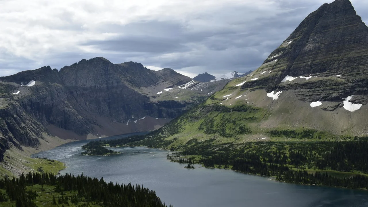
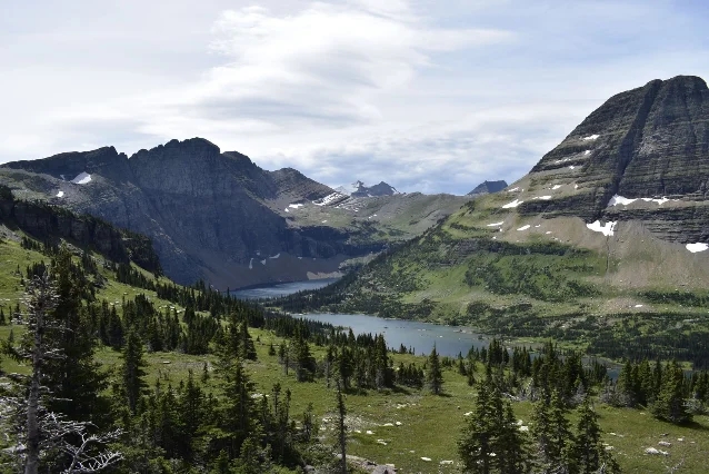
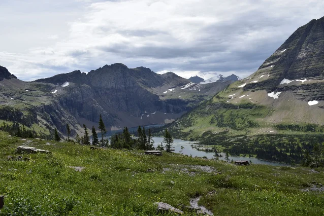
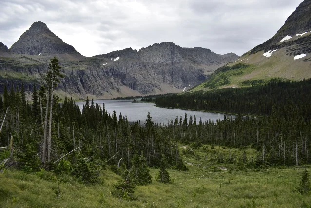
Glacier National Park has over 700 miles of trail, but Grinnell Glacier stands apart because no other route in the lower 48 puts you this close to an active glacier without a multi-day commitment. The hike combines two boat crossings, a sustained climb through subalpine meadows, and a finish at the milky-blue Upper Grinnell Lake with the receding glacier looming above. Wildlife encounters — grizzlies, mountain goats, hoary marmots — are frequent enough that most hikers see something large before the first mile is done.1
Route overview
The hike starts from the Grinnell Glacier Trailhead (or Many Glacier Hotel) and climbs gradually through pine forest along the north shore of Swiftcurrent Lake, then Lake Josephine, before gaining serious elevation on switchbacks above treeline. The upper section is fully exposed — rock, scree, and small snowfields well into summer — ending at the viewpoint above Upper Grinnell Lake.2
Key waypoints (walking the full route from the trailhead):
- Grinnell Glacier Trailhead — 4,500 ft elevation; a tiny parking area off Many Glacier Road
- Lake Josephine junction — ~1.9 mi; the trail meets the shoreline trail from Many Glacier Hotel here
- Grinnell Lake — ~3.4 mi (one-way); the teal lake visible from the valley floor; short spur adds 0.2 mi
- Grinnell Falls viewpoint — ~4.0 mi; a 200-ft cascade crossing the trail; slippery rocks on descent
- Upper alpine zone — ~4.5 mi onward; switchbacks on open talus with full exposure to afternoon sun and lightning
- Upper Grinnell Lake viewpoint — 5.3 mi; end of maintained trail; glacier, Salamander Falls, and the iceberg-studded lake
Terrain character shifts markedly. The lower half is shaded, relatively flat, and accessible to fit hikers of most ages. Above the treeline it turns sustained and rocky; there is essentially no shade for the final two miles, and the trail narrows to exposed ledges in a few spots.1
Permits and entry fees
No hiking permit is required for Grinnell Glacier.1 In 2026, Glacier National Park is also not requiring vehicle reservations — a change from recent years when the Many Glacier area had day-use permit requirements.1 The standard park entrance fee is $35 per vehicle (7-day pass), or free with an Interagency Annual Pass.4
Getting there: parking and the boat shuttle
Driving: Many Glacier is on the east side of the park, accessed via MT-89 from Browning and then the Many Glacier Road. The trailhead parking lot is about 1.5 miles past the Many Glacier Hotel. It holds roughly 20–25 vehicles and is reliably full by 7:00 AM on summer weekends.1 If you arrive after 7 AM and the lot is full, park at the Many Glacier Hotel or Swiftcurrent Motor Inn area and walk the extra 1.9 miles to the junction — it adds mileage but is well-graded.
Boat shuttle (recommended): Glacier Park Boat Company runs a two-leg crossing that cuts 3.4 miles from the round trip. The first boat crosses Swiftcurrent Lake (10 minutes), a short walk connects to the dock, then a second boat crosses Lake Josephine (12 minutes). Passengers step off at the Lake Josephine west dock and join the main trail 0.4 miles from the Grinnell Glacier junction.5
2026 boat pricing (Many Glacier):
| Ticket | Price |
|---|---|
| Adult — round trip | $41.70 |
| Adult — one-way return | $20.85 |
| Child (4–12) — round trip | $20.85 |
| Child under 4 | Free |
Departures run from June 10 through September 19; the earliest departure is 8:30 AM (hikers must disembark). Reserve tickets at reserve.glacierparkboats.com — boats sell out weeks in advance during July and August.5
Camping: Many Glacier Campground
Many Glacier Campground sits at ~4,500 ft on the east side of the park, about 2 miles from the hotel and trailhead area. It is the only front-country campground in the Many Glacier valley, which makes it the obvious base for an early-morning Grinnell start.4
Key logistics:
- Reservations: All sites require advance booking at Recreation.gov; most open 6 months in advance, though a small number of sites release 4 days out
- RVs: Most sites and drive lanes are small — only a few sites accommodate trailers over 21 feet; RVs requiring slide-outs should book St. Mary Campground (22 miles away)
- Hookups: None. No electric, water, or sewer connections at individual sites; shared drinking water is on-site; one dump station at the entrance
- Bears: The area has regular grizzly and black bear activity. Bear-resistant lockers are at every site; all food, coolers, cookware, and toiletries must be stored inside a locked vehicle or a locker at all times when not in use
- Booking link: recreation.gov/camping/campgrounds/251869
Best season and conditions
July and August are the most reliable months: the trail is clear of snow, the boats run their full schedule, and daytime temperatures stay in the 60s–70s°F. Wildflowers peak in mid-July.
Late June is viable but expect snow patches in the upper alpine section above mile 4. Traction devices (microspikes) are worth packing for early-season trips. The boat schedule starts June 10.5
September is quieter, especially after Labor Day. Temperatures drop and early snowfall is possible — the trail can become icy above treeline by late September. The boat season ends September 19.5
Afternoon lightning is the main weather hazard. The upper section is fully exposed above treeline; aim to be at the summit by noon and descending by 1–2 PM to stay ahead of afternoon storms. Start no later than 7 AM without the boat; 8:30 AM with the first boat departure.
6 photography spots along the route
- Many Glacier Hotel dock at sunrise (mile 0): Before you start hiking, the hotel sits between Swiftcurrent Lake and Swiftcurrent Mountain. On calm mornings, the lake reflects the mountain. Light hits the face between 7–9 AM. Face northeast.7
- Swiftcurrent Lake from the boat (~mile 0.5): The boat crossing gives you a low-angle view of Grinnell Point and Mount Henkel with the lake in the foreground. Bring a 24–50mm and shoot from the stern as you depart.
- Lake Josephine shoreline (~mile 2 from trailhead): The trail hugs the north shore through spruce and fir. The lake is calm until wind picks up mid-morning; get here early for reflections.1
- First open view (~mile 4.0–4.5): Once the switchbacks begin, Mount Gould dominates the frame to the southwest. This is the spot for telephoto compression shots of the glacier with hikers in the foreground — use a 70–200mm to stack the ice fields behind the trail.1
- Grinnell Falls (~mile 4.0): The waterfall pours down a polished cliff face directly across the trail. Use a slow shutter (1/30 or slower) for silky water; the gorge blocks most wind. Best light: mid-morning when sun enters the canyon.
- Upper Grinnell Lake viewpoint (~mile 5.3): The glacier's remaining ice sits above the teal-green lake. Iceberg fragments in the lake are common in early season. Shoot from above the terminal moraine looking northwest; afternoon light hits the ice faces; the mountain shadows in the east are usable late in the day.1
Gear and safety notes
Footwear: Full trail runners or hiking boots required. The upper section has loose talus, and the Grinnell Falls crossing has wet, polished rock. Sandals are unsuitable above the lakes.
Water: Carry at least 3 liters. The upper route is shadeless; heat build-up is fast on July afternoons. Water sources exist but require treatment.
Bear spray: Mandatory to carry in Glacier — grizzly encounters have occurred on this trail. Keep it accessible (hip holster, not packed inside a bag). Hike with noise, especially around blind corners and near Cataract Creek.1
Turnaround option: Lake Josephine (3.4 mi from the trailhead) makes a natural stopping point for less fit hikers or those with children. It adds only 60 ft of elevation and offers a full valley view.
Children: Manageable to Lake Josephine; above that requires steady footing on talus. Not stroller accessible above the lakeshore trails.
Cell service: Unreliable throughout the Many Glacier corridor. Download offline maps before arrival.4
围绕这条内容继续补充观点或上下文。