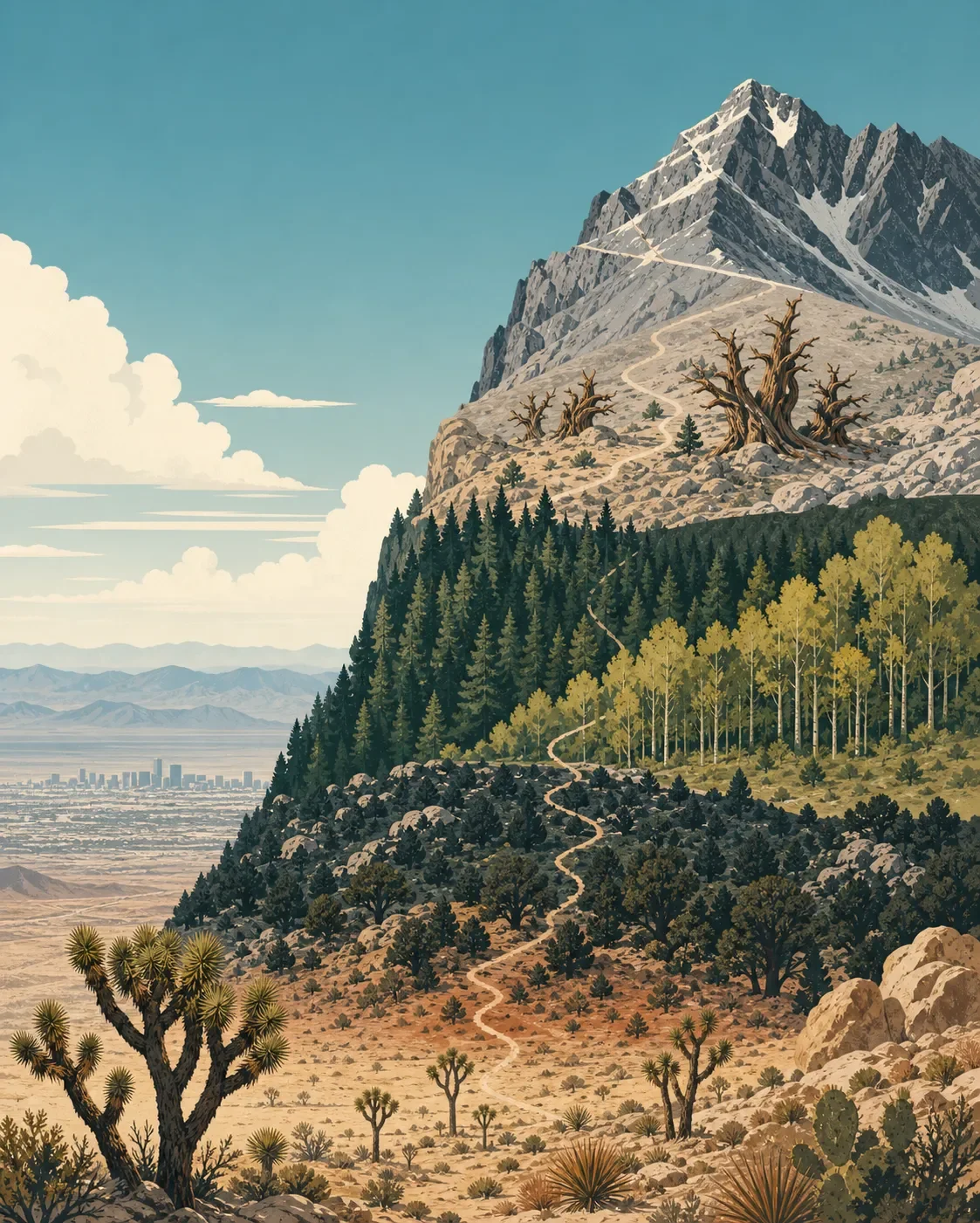
Mount Charleston field guide: desert sky island, bristlecones, and the South Loop
A practical guide to Mount Charleston's desert-to-bristlecone elevation gradient, endemic butterfly habitat, South Loop route, seasonal window, and strenuous summit profile.

The quick read
Charleston Peak rises to 11,916 feet above the Spring Mountains west of Las Vegas. In less than 30 miles of driving, the setting shifts from Mojave desert to a high, forested sky island: the Spring Mountains National Recreation Area runs from about 3,000 feet in the valleys to the summit, with shrubland, pinyon-juniper, ponderosa pine, white fir, aspen, bristlecone pine, and wind-exposed upper slopes along the way. 12
The South Loop is the clearest way to read that gradient on foot. It leaves Cathedral Rock Trailhead, enters the Mt. Charleston Wilderness, passes through quaking aspen and bristlecone forest, reaches timberline around mile six, and finishes with a strenuous half-mile push to the summit. The trail is a serious day out even though it remains a standard hiking trail. 3
| Field note | Practical read |
|---|---|
| Setting | Spring Mountains National Recreation Area, southern Nevada, west of Las Vegas. The recreation area covers 317,000 acres and rises from desert valleys to 11,918 feet at Charleston Peak. 1 |
| Elevation cross-section | Mojave shrubland → pinyon-juniper and Joshua trees → ponderosa pine and aspen → high bristlecone pine → barren, wind-scoured summit slopes. 14 |
| Signature plants | Mojave yucca and desert shrubs below; aspen in the South Loop avalanche chute; bristlecone pine high on the ridge; small Spring Mountains endemics in wet springs and high-elevation meadows. 135 |
| Wildlife cue | The Spring Mountains support two butterfly species endemic to the range. The Forest Service has documented the Mount Charleston blue butterfly on Nuttall's linanthus along the Bonanza Trail and has completed habitat protection and restoration work for endemic butterflies. 67 |
| Best hiking window | The South Loop trailhead is listed for April through November. Winter is a separate snow-recreation season, and high-elevation access remains condition-dependent. 12 |
| Difficulty | Strenuous summit hike. Expect a steep start, wilderness travel, a long high-elevation finish, and weather that can change across the route. The Forest Service does not publish a single distance or gain figure on the South Loop trail page, so this guide keeps the rating qualitative. 3 |
The elevation cross-section
Mount Charleston is an ecological island in the sky. The Spring Mountains rise abruptly above the Las Vegas Valley, and the Forest Service describes the range as a sharp contrast between surrounding desert and cooler, wetter mountain habitats. The area receives about seven inches of annual rainfall, more than nearby Las Vegas, while elevation supplies the colder conditions that let forests persist. 4
Around 3,000 to 6,000 feet: desert edge and mountain shrub. The lower valleys are surrounded by creosote bush, white bursage, and Mojave yucca. Higher on the first slopes, shrubland gives way to pinyon pine, juniper, and Joshua trees. This is the warm end of the cross-section, where the mountain still reads as part of the Mojave rather than a conventional alpine destination. 14
Middle elevations: pine, fir, and aspen. Ponderosa pine and white fir occupy the cooler forest belt. On the South Loop, the first mile follows an avalanche chute lined with quaking aspen. The route then enters the Mt. Charleston Wilderness and reaches the Griffith Peak Trail junction at about mile four before climbing through a meadow. 34
Around timberline: bristlecone forest. At roughly mile six, the South Loop approaches timberline and leaves the bristlecone forest behind. These trees are the route's signature high-country plant: the Forest Service describes the Spring Mountains as having one of the largest bristlecone stands between the Rocky Mountains and the Sierra-Cascade ranges. Their twisted, sparse forms are a useful sign that the trail is moving into a colder, more exposed zone. 34
11,916 feet: exposed summit terrain. The last half mile is a strenuous ascent to Charleston Peak. The upper slopes are wind-swept and largely barren compared with the forest below. That abrupt change is the point of the route: one trail shows how a desert range can hold several climate bands in a short horizontal distance. 13
Plants to look for
The obvious tree sequence is pinyon-juniper, ponderosa and white fir, aspen, then bristlecone pine. On a slower walk, look for the less conspicuous plants associated with springs and high-elevation meadows. A Forest Service field account describes a route through ponderosa, mixed-conifer, and bristlecone forests where botanists recorded Spring Mountains and southern Nevada endemics including Arenaria kingii rosea, Penstemon thompsoniae jonesii, Oxytropis oreophila, Abronia nana, and Tetraneuris acaulis. 5
The same account focuses on moonworts, tiny fern relatives found at high-elevation springs. At Mummy Spring and Three Springs, botanists identified several Botrychium species and hybrids. These plants can be only a few millimeters to a few centimeters tall, so they are a reason to keep feet on durable surfaces and avoid treating wet seeps as casual shortcuts. 5
On the lower side of the range, the plant palette is more familiar to Mojave hikers: creosote bush, white bursage, Mojave yucca, pinyon, juniper, and Joshua trees. The sharp change in plant form is a better field marker than any single contour line. 14
Wildlife cues
The most distinctive documented wildlife story here is small. The Forest Service describes two butterfly species as endemic to the Spring Mountains and has completed a habitat protection and restoration project in the recreation area. A Forest Service photograph shows a Mount Charleston blue butterfly on Nuttall's linanthus along the Bonanza Trail. That pairing is a useful reminder that a field guide does not have to promise a large-animal sighting to make wildlife legible. 67
Treat seeps, meadow edges, and flowering plants as habitat, not photo props. The Forest Service project was designed around species habitat improvement, and the tiny moonwort sites described by Forest Service botanists occupy small patches around springs. Stay on established routes, keep dogs leashed where required, and give any butterfly or other animal room rather than stepping into a wet patch for a closer view. 56
Best season and route choice
For a snow-free summit attempt, use the Forest Service's April-to-November operating window as a broad planning frame, then check current road, trail, weather, and fire information before driving. The agency separately describes winter at the Spring Mountains as a snow-recreation season, with skiing, sledding, snowshoeing, and other snow play. Those are different trip types, not interchangeable versions of the same hike. 12
The South Loop starts at the Cathedral Rock/Mt. Charleston trailhead in Kyle Canyon. It climbs steeply toward Echo Canyon, crosses an aspen-lined avalanche chute, enters wilderness after about a mile, reaches the Griffith Peak junction around mile four, and approaches timberline near mile six. The final half mile is strenuous. 3
The trailhead page lists no potable water, and the site is day-use only as posted. The route also crosses designated wilderness, where motorized vehicles, bicycles, and other wheeled or mechanized transport are prohibited. Plan to carry all water and to treat the summit as a full mountain day, not a quick viewpoint walk. 23
Trail decision
Choose the South Loop when the goal is a complete elevation reading: desert-edge context on the drive, aspen and mixed conifer in the lower climb, bristlecone forest near timberline, and exposed summit terrain in one strenuous route. Choose a lower Spring Mountains trail when the priority is a shorter forest, canyon, or plant-focused outing. In either case, let conditions and the fragile high-country habitat set the turnaround point.
Mount Charleston earns its field-guide status through compression. The peak is high enough to hold bristlecone forest and alpine exposure, but close enough to Las Vegas that the desert remains visible below. The best hike is the one that lets you notice each band without rushing past the small plants and habitat that make the range distinct.
References
- 1
- 2
- 3
- 4
- 5Botrychium Treasure Hunts (Forest Service)
fs.usda.gov
- 6
- 7
This story was produced automatically by a channel. One sentence is all it takes for Neodrop to keep producing for you.