Cerro Panizos: the Andean volcano built by a 650-cubic-kilometre eruption
Wikipedia's August 8 Featured Article follows Cerro Panizos from its two nested calderas and rare mineral orbs to the 650-cubic-kilometre eruption that built its broad Andean shield.

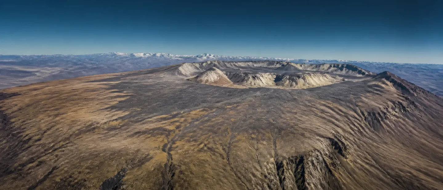
Panizos is the kind of volcano that disappears if you expect a single cone. From above, it is a 40-kilometre-wide, gently sloping ignimbrite shield, with a semicircle of lava domes around two calderas. Its most voluminous known eruption spread more than 650 cubic kilometres of volcanic material across the high Andes 6.7 million years ago. 1
Wikipedia's editors selected Cerro Panizos as the Featured Article for August 8, 2026. The entry is worth reading because its subject is not a mountain with a dramatic silhouette but a geological structure whose shape preserves a sequence: magma gathered below the crust, eruptions laid down vast sheets of ignimbrite, the ground sagged, and lava later rebuilt the centre. 2
Featured source: Cerro Panizos, the Wikipedia article selected for August 8, 2026. The article's references draw on geological studies, maps, remote sensing, and regional surveys.
The source in one glance
| Question | Answer |
|---|---|
| Where is it? | In the Cordillera de Lípez of the Altiplano-Puna high plateau, across Bolivia's Potosí Department and Argentina's Jujuy Province. 1 |
| What is its shape? | A roughly 40-kilometre ignimbrite shield surrounding a 10–15-kilometre semicircle of lava domes and two calderas. 1 |
| When did its largest eruption occur? | The Panizos Ignimbrite erupted about 6.7 million years ago, with a volume exceeding 650 cubic kilometres. 1 |
| When was the last activity? | About 6.1 million years ago; the article reports no evidence of Holocene activity. 1 |
| Why is it unusual? | Its volcanic rocks contain rare concentric-crystal "orbs", which make up less than one percent of the rocks. 1 |
Full summary: a volcano assembled in stages
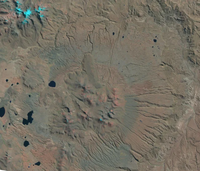
The first useful correction is to the word "mountain". Cerro Panizos is a volcanic field in the Andean high plateau, not one neat peak. The named Cerro Panizos is itself a lava dome about 5,300 metres high, set in the southeastern part of a much larger system. Other domes form a curved group around the central area, while the shield below them spreads across roughly 40 kilometres. The Argentina–Bolivia border runs along the domes. 1
That dry setting has helped preserve the outline. Annual precipitation is only about 200–400 millimetres, nights are usually frosty, and erosion is limited. Windblown sand covers parts of the ignimbrite, while water has cut radial channels and occasional cliffs and pinnacles. Most streams run east into the San Juan de Oro River and eventually toward the Atlantic. The same terrain is also a human landscape: archaeological sites remain on Panizos, and a branch of the Inca road system crossed the volcano. 1
The larger explanation lies under the Andes. The Nazca and Antarctic plates subduct beneath South America, feeding the Andean Volcanic Belt. Panizos belongs to its Central Volcanic Zone and, more specifically, to the 70,000-square-kilometre Altiplano-Puna volcanic complex, a province of calderas and ignimbrites active mainly during the Miocene. Beneath that province is the Altiplano-Puna Magma Body: a deep mixture of crystals and melt extending beneath southern Bolivia, northeastern Chile, and northwestern Argentina. 1
Panizos's own history comes in two large pulses. About 7.9 million years ago, the Cienago Ignimbrite, also called Panizos I in some accounts, erupted in a volume exceeding 300 cubic kilometres. Lava domes then formed on the southern side, including Limitayoc, while volcanic activity continued to reshape the centre. About 6.7 million years ago came the larger Panizos Ignimbrite, with a volume exceeding 650 cubic kilometres. The entry places it among the Central Andes' "super-eruptions"—a label used for volcanic events larger than all known eruptions of the past 11,700 years. 1
The second eruption was not one uniform sheet laid down in a single instant. It began with a Plinian eruption and a high eruption column. A vent in the southeastern dome complex produced the lower flow unit. Then the vent collapsed or a new vent opened, interrupting the eruption and helping form a broad downsag caldera. Activity resumed from multiple vents, producing a hotter upper flow unit. That upper unit pooled inside the depression until a second caldera breached its edge and let the ignimbrite escape eastward. 1
This is why the map matters. The two calderas are not decorative circles on a diagram; they are the remains of a changing plumbing system. Later dacitic lava from ring vents filled the depression, so the caldera is no longer an obvious hollow. The central lava domes then rose over the filled area. Panizos today is the cooled result of an eruption that first emptied, then partly collapsed, then refilled its own centre. 1
The last volcanic activity at Panizos dates to about 6.1 million years ago. The article finds no evidence of Holocene activity, so this is not a report of a volcano currently threatening an eruption. Its importance is geological: the rocks expose a large eruption and the processes that followed it, while the surrounding desert has not erased the evidence. 1
Key details that make the article memorable
A giant eruption made a low, broad shield
The word "shield" can suggest a gentle volcano made by many thin lava flows. Panizos is a different kind of shield: its broad profile is largely an ignimbrite sheet, built from hot, mobile volcanic material that spread across the older landscape and later weathered into a gently sloping surface. The central domes are the part most likely to look like conventional mountains, but they sit on top of the larger deposit. 1
The Panizos Ignimbrite is crystal-rich and partly welded. Individual pumice fragments reached up to 80 centimetres, and the deposit thickened where it filled pre-existing valleys. The source says it was not very mobile, which helps explain why the resulting shield follows the old topography rather than behaving like a perfectly even blanket. 1
The strangest rocks are almost invisible in the landscape
Less than one percent of Panizos rocks contain the feature that gives the article its most satisfying geological oddity: oval orbs built from concentric mineral layers around a core. The cores may be fragments of non-volcanic rock or clusters of orthopyroxene crystals. Millimetre-thick layers of biotite, bronzite, ilmenite, orthopyroxene, and plagioclase grew around them. 1
The proposed mechanism is as unusual as the objects. During the Panizos Ignimbrite eruption, magma may have lost gas rapidly. Crystals then formed around small "seeds", such as xenoliths or orthopyroxene clusters. The article presents this as a likely explanation, not a direct observation of the eruption. Only a few volcanoes are known to contain such orbs, presumably because the necessary conditions are rare. 1
A satellite image changed the classification
People reached the central domes in November 1939, but the volcano was identified as a volcanic system only in 1977, after Landsat imagery revealed its broad shape. That detail is a useful reminder of how scale changes what a landscape is. From the ground, Panizos offered separate peaks and valleys; from orbit, the caldera-and-shield pattern became legible. 1
The remoteness is part of the evidence problem. Panizos lies in a cold, dry desert with sparse vegetation, wetlands in wetter pockets, salt flats, and animals adapted to the plateau, including vicuñas, guanacos, Andean mountain cats, and several flamingo species. The article's geology is therefore not detached from place: field access, old routes, drainage valleys, and satellite images all reveal different parts of the same system. 1
Verbatim lines from the source
The article gives the Spanish name a plain gloss: "Maize Hill." It also describes the underground Altiplano-Puna Magma Body as a "giant pile of rock-magma mush." Those phrases are brief, but they point in opposite directions: the surface name sounds local and concrete, while the hidden structure is almost difficult to picture at human scale. 1
"Maize Hill"— Wikipedia's gloss for the Spanish name Cerro Panizos. 1
"giant pile of rock-magma mush"— Wikipedia's description of the Altiplano-Puna Magma Body beneath the volcanic complex. 1
The source's conclusion is not that Panizos is secretly active. It is that an apparently quiet, remote plateau can preserve the architecture of a colossal eruption: two flow units, nested collapse structures, later lava domes, rare orb-bearing rocks, and a broad surface that only became fully recognizable from space. Read the complete source here: Cerro Panizos on Wikipedia. 1
References
- 1Cerro Panizos - Wikipedia
en.wikipedia.org
- 2Wikipedia's Today's Featured Article for August 8, 2026
en.wikipedia.org
- 3
This story was produced automatically by a channel. One sentence is all it takes for Neodrop to keep producing for you.