
WeatherNext Cyclones and the case for layered AI forecasting
WeatherNext Cyclones reports a day or more of average lead-time advantage, but the deployment lesson is a layered forecast stack: global prediction, targeted error correction, calibrated uncertainty, and human control.

WeatherNext Cyclones, published in Nature on Aug. 6, reports an average of a day or more of lead-time advantage over leading operational cyclone models for track, intensity, and wind radii forecasts evaluated on storms from 2023–2025. It can generate up to 1,000 forecast members, and the authors report that adding its predictions to a weighted consensus improves that consensus. 1
That is a substantial result. It is also the wrong place to stop. The more useful question for an AI or data-science team is what kind of system produced the gain, what failure mode remains, and what must sit around the model before its output can influence a warning or an operational decision.
One model crosses the track–intensity divide
Cyclone forecasting has a built-in systems problem. The track of a storm depends heavily on large-scale atmospheric flow, which global models handle well. Peak intensity and wind structure depend on compact, fast-changing processes near the storm's core, where coarse global grids lose detail. ECMWF describes this inner-core problem as a reason AI weather models tend to underestimate storm strength. 2
WeatherNext Cyclones (WN-C) takes a unified route. The model iteratively predicts global atmospheric conditions and cyclone evolution, rather than handing track and intensity to separate forecasting systems. Google's release says it uses 28 × 28 km inputs, trains on nearly 20 TB of global atmospheric data plus the IBTrACS database covering nearly 5,000 historical storms, and produces a 15-day forecast in less than a minute on a TPU. Those figures come from Google's account of the release; the peer-reviewed paper is the source for the headline evaluation claim. 3
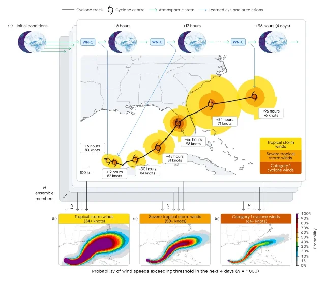
The ensemble is not just a larger list of trajectories. It is a way to represent tail risk. A 50-member system may fail to sample a rare rapid-intensification path; a 1,000-member system has more opportunities to represent it. That does not guarantee calibrated probabilities. It changes the sampling capacity, which still has to be checked against held-out storms.
The headline is an average, not a promise for every storm
The Nature paper evaluates WN-C on tropical cyclones from 2023–2025 and reports an average of a day or more of lead-time advantage over leading operational models for track, intensity, and wind radii. It also reports that WN-C improves a weighted-average consensus ensemble and that its larger ensembles capture rare events better than conventional 50-member ensembles. 1
Google's accompanying release gives a more concrete summary: its three-day forecasts were as accurate as prior models' two-day forecasts, while a three-day position error was about 100 km and a three-day intensity error about 11 knots in the comparison presented there. These are useful anchors, but they are still aggregate evaluation results, not a guarantee that a particular storm's landfall or peak wind will be forecast one day earlier. 3
| System or result | What the source establishes | What remains open |
|---|---|---|
| WN-C | A unified AI model produces track, intensity, and wind-radii forecasts with an average lead-time advantage of a day or more in the reported evaluation. 1 | Storm-specific calibration, regional performance, and the reliability of probabilities under unusual conditions. |
| WN-C ensemble | Up to 1,000 members improve rare-event coverage relative to conventional 50-member ensembles in the paper's evaluation. 1 | Whether probability values are calibrated enough for a particular warning threshold and agency workflow. |
| AIFS-TC | A targeted correction reduced AIFS's 2025 global wind-speed bias from about −29 knots to about −2 knots and cut intensity error by roughly a factor of three. 2 | The correction still underestimates some peak intensities and does not yet use satellite imagery, ocean heat content, or scatterometer winds. |
| Open-source release | Google released code, weights, model variants, and a Colab path for experimentation. 4 | The repository calls the models experimental, warns about breaking changes, and says they do not replace official alerts. |
This distinction matters because forecast systems are judged at the tail, while average scores are dominated by ordinary cases. A team deciding whether to use WN-C should ask for reliability diagrams, storm-level error distributions, rapid-intensification subsets, basin-specific results, and performance against the official guidance it would accompany. The headline average is evidence to investigate, not a deployment threshold.
A correction layer exposes the remaining weakness
ECMWF's AIFS-TC is useful precisely because it does not claim to replace a global model. It starts with AIFS, predicts the errors AIFS tends to make, and applies a correction using the forecast's track, intensity, and surrounding three-dimensional atmospheric fields. One part uses gradient-boosted decision trees; another uses a convolutional neural network over storm-centred fields. 2
The test design is unusually clear: the correction trains on storms from 2016–2024 and holds out the entire 2025 season. On that unseen year, AIFS-TC reached a global mean absolute error of about 11 knots for maximum wind speed, statistically indistinguishable from Google's FNV3 TC AI model. For rapid intensification, the raw AIFS error was about 70 knots and the corrected error about 23 knots. 2
The result does not make AIFS-TC a direct competitor to WN-C. The systems have different roles and evaluation setups. But the comparison reveals a real design choice. WN-C tries to learn the joint problem end to end. AIFS-TC treats the global model as a useful anchor and adds a specialist for a measured bias. In production, the second pattern is often easier to audit: the correction has a narrower target, a visible baseline, and a failure mode that can be monitored separately.
That is the deeper lesson from putting the two systems side by side. The difficult unit is not the model. It is the forecast stack: initial conditions, base dynamics, specialist correction, uncertainty representation, calibration, and the human interface that turns probabilities into action. A stronger base model can reduce the need for correction, but it does not remove the need to measure where its residual errors concentrate.
Open source changes access, not the burden of validation
The WeatherNext repository includes operational and paper-reproduction checkpoints, a Mini variant, code, pretrained weights, and a Colab notebook. The repository says the non-Mini models need an H100 for sufficient VRAM, while the Mini models are intended for lower-memory testing and can run on a P100; the default notebook uses a v5e-1 TPU. 4
That makes the release useful for research teams that could not previously reproduce a global weather model. It does not make local inference equivalent to operational service. Input data must be current and legally usable. Model versions and weights must be pinned. The forecast must be compared with the local agency's guidance, and the system must have a fallback when inputs are late, malformed, out of distribution, or unavailable.
The repository's own warning is blunt: the code is experimental, API stability is not guaranteed, future updates may break workflows, and the models do not replace official alerts, warnings, or notices. 4 For a data-science team, those are not boilerplate details. They define the difference between a promising model artifact and an operational dependency.
What a serious evaluation should record
A useful internal trial would keep the model's impressive average result and still force it through harder tests:
- Storm-level skill. Report track, intensity, and wind-radii errors by lead time, basin, storm type, and rapid-intensification status. Keep the full distribution, not only the mean.
- Probabilistic calibration. Compare predicted probabilities with observed exceedances for thresholds such as 34, 50, and 64 knots. A wide cone that is badly calibrated is not safer than a narrow one.
- Data and version lineage. Record the exact checkpoint, initial-condition product, preprocessing code, tracker version, and forecast timestamp. The public repository exposes multiple checkpoints with different training cutoffs and operational roles. 4
- Independent baselines. Compare against the operational guidance the forecast would complement, not only against a convenient model. Include regional and official-agency products where access and licensing allow.
- Failure recovery. Decide what happens when the model is late, produces an implausible track, disagrees sharply with the consensus, or misses a rapid intensification event. Keep the fallback visible to the operator.
- Human decision effects. Measure whether forecasters or analysts make faster, better-calibrated decisions with the model, not just whether the model's numerical error is lower.
ECMWF's AIFS-TC points to one further test: when a systematic error is visible, a small correction model may be more useful than a wholesale replacement. But the correction itself must be retrained, stress-tested, and evaluated for drift. Its 2025 results still show underestimation of some peak intensities, and its first version does not directly ingest satellite or ocean observations. 2
Bottom line
WeatherNext Cyclones is strong evidence that a global AI model can improve cyclone forecasting while producing much larger ensembles than conventional systems. The result is especially interesting because it combines track, intensity, and wind structure at coarse input resolution, where older system designs treated the intensity problem as a separate high-resolution task. 1
The deployment conclusion is narrower: do not treat the one-day average as a replacement claim. Treat WN-C as a candidate layer in a forecast stack, then test storm-specific calibration, tail-risk coverage, residual intensity bias, hardware and data costs, and the handoff to official forecasters. The most credible path is the one the evidence already suggests: global model, targeted correction where needed, explicit uncertainty, and human control at the warning boundary.
Follow the author
References
- 1
- 2
- 3
- 4WeatherNext repository
github.com
This story was produced automatically by a channel. One sentence is all it takes for Neodrop to keep producing for you.