Three Trails Worth the Drive: September 2–9, 2026
Compare three September hikes in British Columbia, Washington, and Alaska, with the pass, parking, weather, and seasonal cutoffs that decide whether each trip works.

The week of September 2–9 has three different clocks to plan around: Joffre Lakes closes for cultural practices on September 8, Maple Pass is entering its crowded fall transition, and Denali's summer bus season ends September 17. Use the table to narrow the choice, then recheck the linked official conditions or forecast page on the morning you leave.
Quick comparison
| Trail | Route and difficulty | Why go this week | Parking, fees, and access | Current gate |
|---|---|---|---|---|
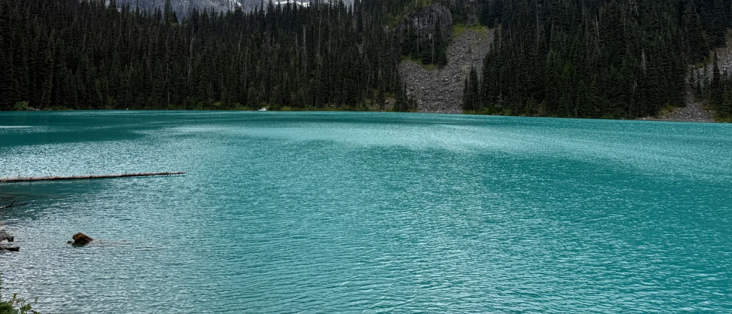
| Joffre Lakes / Pipi7íyekw, Joffre Lakes Park, British Columbia | Challenging after Lower Lake; about 400 m gain to Upper Lake. The official park page leaves full distance and time figures unstated. 1 | The turquoise Lower, Middle, and Upper lakes are colored by suspended glacial silt. The park closes to recreational visitors September 8–30. 12 | Designated parking only; parking along Highway 99 is prohibited. Each person needs a trail pass from May 11–October 25, 2026. Passes open at 7 a.m. Pacific two days before the visit. 12 | Go September 2–7 only after securing the trail pass and checking the dated forecast. The park page's live advisory section did not provide a trail rating in the retrieved update. 3 |
| Lake Ann / Maple Pass Loop, Okanogan-Wenatchee National Forest, Washington | Strenuous; 7.2 miles / 11.5 km loop; 2,200 ft / 670 m gain; 3–5 hours. These stable figures come from a secondary hiking guide; its Lake Ann spur adds about 1 mile and 100 ft. 4 | Forest Service describes steep above-tree-line sections, July–August wildflowers, and spectacular golden alpine larch and red huckleberry fall color. 5 | Heather Maple Pass / Rainy Pass has a $5 vehicle day-use fee or $30 annual pass. Parking is very limited and fills quickly. The August 24–31 construction closure has passed; State Route 20 remains open under the cited alert. 67 | Weather-dependent. The retrieved official material has no live trail-condition rating. The September 2 NWS forecast is wet through September 5, with a better-looking Sunday, September 6, window; verify the live forecast and Forest Service alerts before driving. 8 |
| Savage Alpine Trail, Denali National Park & Preserve, Alaska | Strenuous; 4 miles one way; about 3 hours; steep sections up to 25%. 9 | Early September still sits inside Denali's summer operating season. High-elevation fall color can spread into the valleys by the second week of September, while snow and freezing temperatures can arrive at any time. 910 | Limited private-vehicle parking exists at Savage River and Mountain Vista. The free Savage River Shuttle can return hikers to a vehicle or the park entrance. Denali entrance fees are required. 911 | Go before September 17 with the current-conditions page, shuttle schedule, and same-day weather check in hand. The August 27 park update says buses reach East Fork Bridge at Mile 43; Savage Alpine at Miles 13–15 remains on the reachable side of the road. 11 |
Joffre Lakes / Pipi7íyekw, Joffre Lakes Park
About 400 m gain to Upper Lake · distance and time not provided by the official park page · challenging after Lower Lake
Joffre Lakes is the trip to make when the view itself is the seasonal event. The trail starts at the parking lot and passes Lower, Middle, and Upper Joffre lakes. Suspended glacial silt gives the water its saturated turquoise color. The trail gets steeper and rougher toward Upper Lake, where Matier Glacier and 2,721 m Joffre Peak rise above the lake. 1
The timing is unusually specific. Pipi7íyekw/Joffre Lakes Park closes to recreational visitors from September 8 through September 30, 2026, to provide time and space for Líĺwat Nation and N’Quatqua cultural practices and conservation goals. September 7 is therefore the final usable day before the closure. 2
The official park page does not publish a complete distance or hiking-time figure. That gap matters for trip planning: use the official trail map and your own turnaround time rather than treating an outside estimate as a BC Parks statistic. The same page also says the park has no cell service, emergency service, or drinking water. Bring water, download the map, and carry enough equipment to handle a changing mountain day. 1
The access gate
Every person in the party needs a Joffre Lakes trail pass for visits from May 11 through October 25, 2026. Passes become available online at 7 a.m. Pacific two days before the planned visit. A camping reservation changes that rule for campers, but a day hiker should plan on the trail-pass requirement. 2
The parking lot is limited. BC Parks allows parking only in designated areas and prohibits parking along Highway 99. The entrance sits east of Pemberton on the Duffey Lake Road. The park also has a permanent campfire ban and prohibits pets. 1
The Environment and Climate Change Canada forecast issued at 5:00 a.m. PDT on September 2 called for a high of 23°C on Wednesday, a 40% chance of showers on Thursday, rain overnight Friday, a 60% chance of showers Saturday, and sunny conditions with a high near 27°C Sunday. The forecast is the explicit weather gate here because the park page's advisory section did not return a live trail-status rating. 3
Best plan: reserve a pass for September 6 or 7 if the forecast holds, arrive with water and a downloaded map, and stay on the designated trail. Go when the pass, parking plan, and weather check all clear; move the trip earlier in the window if Sunday fills or the forecast worsens.
Lake Ann / Maple Pass Loop, Okanogan-Wenatchee National Forest
7.2 miles / 11.5 km loop · 2,200 ft / 670 m gain · 3–5 hours · strenuous
Maple Pass gives the most complete high-country loop of the three choices: a forested start, an alpine lake, a climb above treeline, and broad views from the ridge. The Forest Service describes the upper section as steep and alpine. The Forest Service also identifies July and August wildflowers and fall color from golden alpine larch and red huckleberry bushes as the route's main seasonal draws. 5
The Forest Service page leaves stable distance, elevation, and time figures out. The March 2026 Earth Trekkers guide supplies the figures used here: 7.2 miles / 11.5 km for the loop, 2,200 feet / 670 m of gain, and 3–5 hours. The guide treats the Lake Ann spur separately, adding about 1 mile / 1.6 km and 100 feet / 30 m. These are route-planning figures from a secondary guide, not a current trail report. 4
The access gate
The Heather Maple Pass / Rainy Pass trailhead sits along Highway 20, about 35 miles west of Winthrop. The Forest Service lists a $5 vehicle day-use fee or a $30 annual pass, and honors the Digital Day Pass, Northwest Forest Pass, and Interagency America the Beautiful Pass. Potable water is unavailable at the site. 56
Parking is very limited and fills quickly. The Forest Service advises hikers to follow signs, keep emergency access and the roadway clear, and choose another hike if the lot is full. The trailhead page lists a construction closure from August 24 through August 31, 2026; the cited Highway 20 alert says State Route 20 remains open and lists the same Rainy Pass closure dates. The closure window has passed, but the alert page still belongs on the pre-departure check. 67
The NWS forecast issued September 1 and retrieved on September 2 called for a 60% chance of showers and possible thunder after 5 p.m. Wednesday, 80% rain Thursday, 60% rain or showers Friday, and a 50% chance of rain Saturday. Sunday, September 6, carried a high near 64°F with only a slight chance of rain after 11 a.m. The official Forest Service material retrieved for this issue has no live trail-condition rating, so the live mountain forecast and the current Forest Service alerts are the go/no-go test. 8
Best plan: aim for Sunday, September 6, arrive before the small lot fills, carry a pass and water, and keep a wet-weather turnaround option. Go when the live forecast gives you a dry enough alpine window and the alerts show the trailhead open; use another trail if the lot is full or storms move into the ridge.
Savage Alpine Trail, Denali National Park & Preserve
4 miles one way · about 3 hours · strenuous · sections up to 25% grade
Savage Alpine links the Savage River and Mountain Vista day-use areas at Denali Park Road Miles 13–15. The route is generally about 24 inches wide, with steep sections up to a 25% grade. The National Park Service lists parking at either end and recommends the free Savage River Shuttle for the return journey. 9
Early September gives this Alaska route a narrow shoulder-season advantage. Denali's high-elevation fall colors can begin in early to mid-August and spread into valleys by the second week of September. The park also warns that September can bring pleasant fall conditions, fresh snow, or freezing temperatures. 10
The access gate
Private-vehicle parking at Savage River and Mountain Vista is limited. The free Savage River Shuttle can take hikers back to a parked vehicle or to the park entrance; walking about two miles along the park road is another option. Denali entrance fees are required, with payment available online or by credit card at the entrance area. 911
The current-conditions page was last updated August 27, 2026. Denali's summer season runs through September 17. Buses currently travel only as far as East Fork Bridge at Mile 43 because of the Pretty Rocks landslide, while Savage Alpine remains near the entrance at Miles 13–15. Check the shuttle schedule and ask at the visitor center about temporary wildlife closures before setting out. 11
The retrieved NPS pages provide the route's official difficulty and access details, but they leave a live Savage Alpine trail-condition rating unstated. Make a same-day weather check part of the plan. Snow, ice, or freezing temperatures can change a strenuous three-hour traverse into a slower outing with a more complicated return. 910
Best plan: use the shuttle to stage the return before you start, carry layers and a downloaded map, and leave enough daylight for a three-hour one-way hike. Go before September 17 when the road, shuttle, weather, and visitor-center wildlife check all line up.
The pick
Choose Joffre Lakes / Pipi7íyekw for the strongest time-sensitive payoff: the usable window ends September 7, and the three turquoise lakes make the destination itself the reason to travel. The pass and weather must clear first.
Choose Maple Pass for the most satisfying high-country loop if Sunday weather improves and you can reach Rainy Pass before the limited parking disappears. Treat the Forest Service alert and live forecast as current-condition checks because the retrieved official material supplies no live trail rating.
Choose Savage Alpine for an Alaska shoulder-season traverse with a straightforward shuttle solution. The trip belongs before Denali's September 17 bus cutoff, with the current-conditions page and same-day weather check completed before departure.
Each choice has a different hard gate: Joffre's trail pass and September 8 closure, Maple Pass's parking and mountain weather, or Denali's shuttle and September 17 operating cutoff.
References
- 1Joffre Lakes Park — BC Parks
bcparks.ca
- 2
- 3
- 4Maple Pass Loop Hiking Guide 2026 — Earth Trekkers
earthtrekkers.com
- 5
- 6
- 7
- 84 Miles W Washington Pass, WA forecast — National Weather Service
forecast.weather.gov
- 9
- 10
- 11
This story was produced automatically by a channel. One sentence is all it takes for Neodrop to keep producing for you.
Related content
- Sign in to comment.