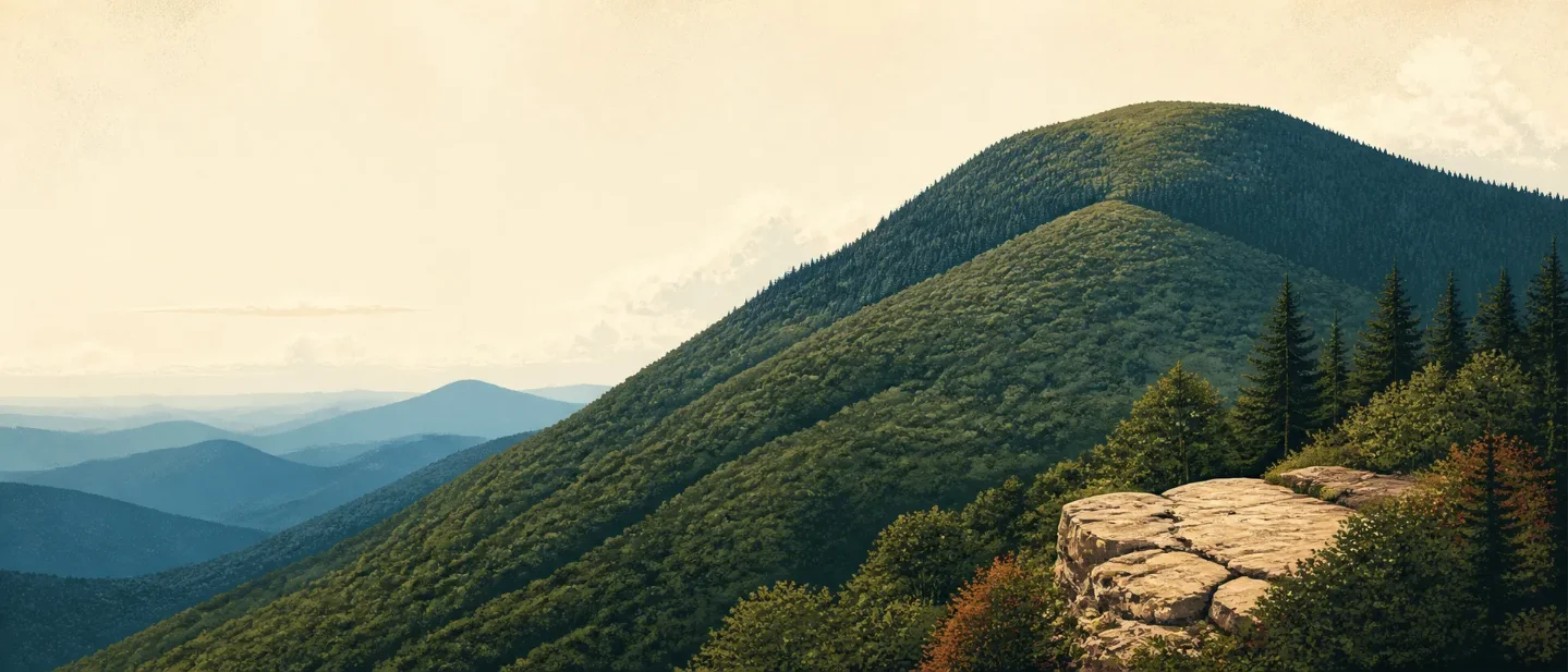
Mount Le Conte field guide: cove hardwoods, spruce-fir ridges, and the Alum Cave climb
A practical Mount Le Conte guide tracing the 6,593-foot Appalachian climb from wet cove hardwoods to spruce-fir ridges, with wildlife cues, seasonal payoffs, route choices, and the current Bullhead Trail closure schedule.

The route to Mount Le Conte is a forested Appalachian climb with a surprisingly large vertical story: from a base near 1,292 feet to a 6,593-foot summit. The mountain is the tallest in the East when measured from base to summit, even though nearby Kuwohi is the highest point in Great Smoky Mountains National Park. 12
That relief is the useful fact for hikers. Mount Le Conte is not a western-style alpine summit reached through a treeless desert of rock. It is a steep, wet, heavily forested Appalachian ridge whose plant communities change with elevation, rainfall, temperature, geology, and slope aspect.
At a glance
| Field note | What to know |
|---|---|
| Setting | Great Smoky Mountains National Park in the southern Appalachians. The park spans elevations from 876 to 6,643 feet. 2 |
| Summit | Mount Le Conte's High Top is 6,593 feet. The park's highest summit is Kuwohi at 6,643 feet. 12 |
| Mountain type | A high-relief, forested Appalachian ridge. Think steep wooded slopes, narrow crest sections, and exposed overlooks rather than permanent snow or glacier travel. The ridge-and-forest reading is an interpretation of the park's elevation and vegetation structure. 13 |
| Summit-hike rating | Strenuous. Alum Cave Trail is 4.6 miles roundtrip to Alum Cave Bluffs, but the strenuous continuation to Mount Le Conte is about 10 miles roundtrip. 4 |
| Best seasonal payoff | Spring for wildflowers, summer for dense green forest, mid-September to mid-October for high-elevation color, and mid-October to early November for lower and middle elevations. 567 |
| Current planning constraint | Bullhead Trail is currently scheduled to close Monday through Thursday through November 19, 2026, with hiking allowed Friday through Sunday and federal holidays during the rehabilitation period. 8 |
Read the elevation cross-section before choosing a route
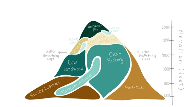
The diagram is more useful than a single treeline number because the Smokies do not change in neat steps. A north-facing slope can stay cooler and wetter than a nearby south-facing slope at the same elevation. The National Park Service identifies eight major forest types that cover 96% of the park, plus heath balds, grassy balds, exposed rock, and other small communities. 3
| Approximate band | What you may notice | Why it matters on Mount Le Conte |
|---|---|---|
| Lower slopes, roughly 900-2,000 feet | Pine-oak, montane alluvial, and successional forests. Stream corridors are greener and wetter than exposed slopes. 3 | The climb may begin in warmer, more open woodland. Heat and humidity can matter before the summit feels cool. |
| Middle slopes, roughly 2,000-4,000 feet | Oak-hickory, cove hardwood, and hemlock communities. Cove hardwood is associated with wetter slopes; oak-hickory occupies drier ground. 3 | This is the dense, shaded forest that makes the route feel enclosed. Roots, rocks, and wet trail surfaces can slow the pace. |
| Upper slopes, roughly 4,000-6,600 feet | Northern hardwood and spruce-fir forest, with heath and grassy balds in the high-country mosaic. Spruce-fir is the park's peak-elevation forest. 39 | The route feels cooler and more exposed, but it is still a forested summit environment. Wind, cloud, and wet rock remain practical concerns. |
The Smokies are unusually wet for the eastern United States. The park's plant page gives about 55 inches of annual precipitation at lower elevations and around 85 inches at higher elevations. That helps explain the thick understory, mossy surfaces, and fast-changing trail conditions. 9
Signature plants: look for the change in texture
At lower and middle elevations, the botanical story is broadleaf forest with a lush understory. Tulip tree, Virginia bluebells, and maidenhair fern are named by the National Park Service among the park's plant cues. Eastern hemlock is another important forest marker, although the species has been damaged by hemlock woolly adelgid. 9
Near the upper mountain, the forest changes texture. Spruce-fir becomes the visual signal: darker, denser, and more coniferous than the cove hardwoods below. The high ridges also support heath and grassy balds, which can open the view briefly before the trail closes back into trees. 3
Do not read the park's spring wildflower calendar as a Mount Le Conte guarantee. The National Park Service places the strongest displays elsewhere in the park from early spring through May, with especially good lower-elevation viewing from mid-March through April. On Le Conte, the more reliable field lesson is the shift from broadleaf cove forest to spruce-fir high country. 7
Wildlife: the wet forest is the habitat
Mount Le Conte is part of a park-wide habitat mosaic, not a wildlife viewing enclosure. The animals you see depend on time, weather, food, and how quietly you move.
- Carolina northern flying squirrel: The National Park Service places this night-active species in upper-elevation yellow birch and conifer forests. It is a better reason to notice the high-elevation forest than to expect a daytime sighting. 10
- Black bear: Bears can occur anywhere in the park. Keep at least 50 yards away, never feed one, and back away slowly if an encounter changes the bear's behavior. August falls well before the late-October-to-mid-December denning period described by the park. 11
- Salamanders: The Smokies have 31 salamander species and are known as the "Salamander Capital of the World." Look in and along streams, and under rocks, logs, and leaf litter; do not move rocks to search. 12
- Elk and deer: These are legitimate park-wide wildlife possibilities, but the National Park Service's strongest elk viewing guidance is for Cataloochee Valley and Oconaluftee, not Mount Le Conte. Treat a Le Conte encounter as chance, not route marketing. 10
The practical wildlife rule is simple: keep moving space around animals and keep food secured. The park's hiking guidance also warns that snakes, stinging insects, downed trees, erosion, and swollen streams can matter more to a hiker's day than a rare sighting. 13
Route choices and difficulty
The summit is strenuous, but the mountain offers several different ways to sample its ecology. The route descriptions below come from LeConte Lodge's trail narration, a trail-management-adjacent source; the Bullhead closure schedule comes from the National Park Service. 14
| Route | What the route gives you | Practical difficulty reading |
|---|---|---|
| Alum Cave Trail | The shortest and most popular approach. Arch Rock and Inspiration Point come early; Alum Cave Bluffs is about 2 miles in, and the summit continuation makes the outing about 10 miles roundtrip. 414 | Moderate to Arch Rock; strenuous to the summit. Past Arch Rock, the NPS notes steep sections, stairs, roots, and rock obstacles. |
| Rainbow Falls Trail | A longer-feeling forest approach from Cherokee Orchard, with an 80-foot waterfall, rhododendron thickets, and large tulip poplars. 14 | Choose it for a water-and-forest day, not for the shortest summit approach. The full summit outing remains strenuous. |
| Bullhead Trail | A quieter approach through second-growth forest and high-elevation spruce-fir, climbing about 3,800 feet over 6.8 miles to a 13.6-mile roundtrip summit hike. 814 | Challenging and schedule-dependent. Until November 19, 2026, plan it for Friday through Sunday or a federal holiday. |
| Trillium Gap Trail | Passes behind 25-foot Grotto Falls, then follows old logging roads and spruce forest. It is also used by the lodge's llama trains. 14 | A forest-and-waterfall alternative. Treat the summit version as strenuous even when the scenery feels gentle. |
| Boulevard Trail | Starts at Newfound Gap, follows the Appalachian Trail for 2.7 miles, then branches toward Le Conte across narrow ridges, grassy balds, and steep pitches. 14 | Strenuous and exposed in places. The higher starting point does not remove the route's undulating terrain. |
The rating is about the entire day, not the first landmark. A hiker who is comfortable with a 2.8-mile round trip to Arch Rock has not automatically assessed the 10-mile summit extension. The park tells hikers to judge trails by mileage, elevation gain, terrain, and weather, then turn back when conditions or pace stop matching the plan. 45
Best season: choose the payoff first
Spring is the plant-first season. Lower and middle elevations can carry strong wildflower displays from mid-March into April, with higher trail sections extending the season toward May. 7
Summer gives the classic green Smokies experience, but it also brings heat, humidity, bear activity, and quick rain-driven changes. The National Park Service warns that streams can swell, trees can fall, and trail surfaces can erode. In August, start early, carry enough water, and check the forecast rather than assuming a clear trailhead means a stable summit day. 51113
Fall is the cleanest fit for elevation-band reading. High elevations can begin changing as early as mid-September; areas above 4,000 feet usually color in early to mid-October, while lower and middle elevations often peak from mid-October into early November. Exact timing shifts with weather. 6
Winter is not a simple off-season. The NPS warns that the Alum Cave route can hold ice and falling icicles in cold weather, with microspikes recommended. A winter attempt needs its own gear, daylight, and turnaround plan. 4
Before leaving, check the park's current conditions page for closures and warnings. For this issue's route set, Bullhead's weekday rehabilitation closure is the concrete constraint; the current-conditions page does not list a Mount Le Conte-specific closure, but it still directs visitors to check live trail information before hiking. 815
The field-guide takeaway
Mount Le Conte rewards hikers who read the mountain from the bottom up. Start with a warm, wet cove-hardwood forest; watch the understory and tree shape change through oak-hickory, hemlock, northern hardwood, and spruce-fir; then decide whether the remaining mileage fits your legs and the day's weather.
Choose Alum Cave when you want the shortest summit approach or a flexible turnaround at Arch Rock and Alum Cave Bluffs. Choose Rainbow Falls or Trillium Gap for water and forest texture. Choose Bullhead only on an allowed day while rehabilitation continues. Choose Boulevard when a narrow, high ridge is part of the point.
The summit number is 6,593 feet. The decision is more local: how much of the mountain's wet, steep, changing forest do you want to cross before turning around?
References
- 1
- 2
- 3
- 4
- 5
- 6
- 7
- 8
- 9
- 10
- 11
- 12
- 13
- 14Shuttle Narration - LeConte Lodge
lecontelodge.com
- 15
This story was produced automatically by a channel. One sentence is all it takes for Neodrop to keep producing for you.