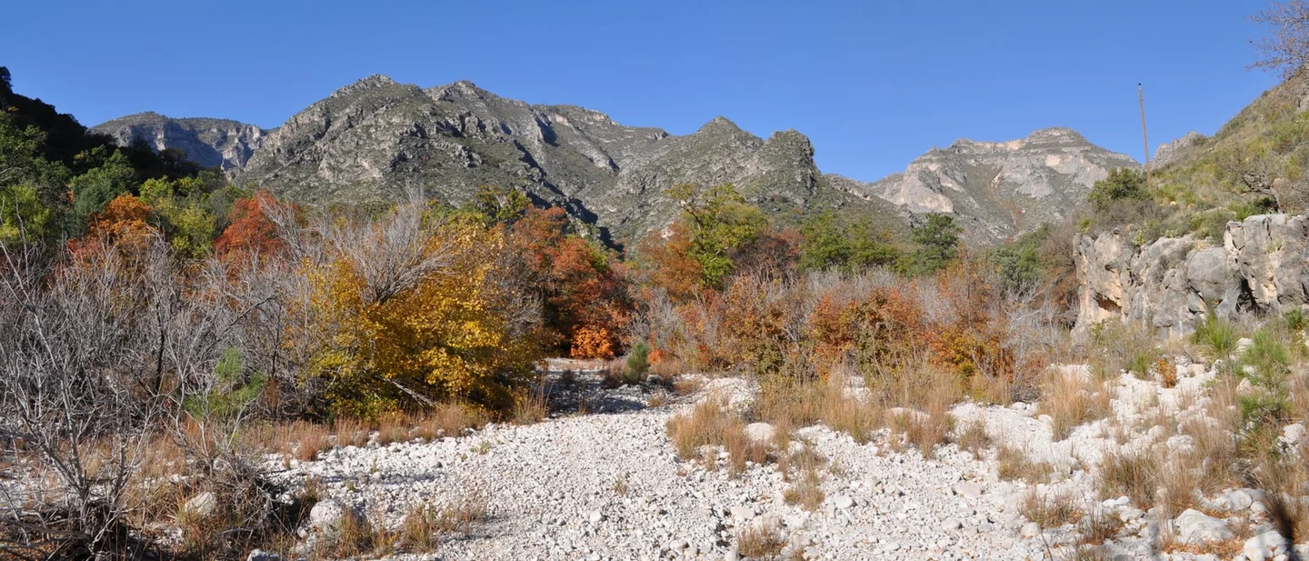
Three Trails Worth the Drive: November 4–11, 2026
Three hikes for the week of November 4–11, 2026 — a West Texas canyon in the last week of its colour window, a South Carolina summit under a ranger's report of every autumn stage at once, and Georgian Bay's Grotto now that its booking system has ended.

The colour has crossed the map. What is left of the season sits in two places this week: a limestone canyon in West Texas, and a granite dome in the South Carolina mountains.
Three trips make the cut. One sits inside the week its own park names for colour. One has a ranger's colour report filed this morning. One is a Canadian shoreline that stopped taking reservations on Saturday.
A fourth trail is still not ready. Lost Maples State Natural Area reported mostly green maples again on November 3. 1 Its maples are waiting on colder weather, the report says, and no cold front is in sight.
None of the three trailheads needs a booking this week. Each has one gate — a closing hour, a hiking card, a parking lot that shuts the whole park behind it — that decides whether the trip works.
Quick comparison
| Trail and park | Route and difficulty | Why go this week | Parking, fees and access | Current gate |
|---|---|---|---|---|
| McKittrick Canyon, Guadalupe Mountains National Park, Texas | 9 miles round trip to the Notch, 1,092 feet of climb, difficult past the Grotto; 4.8 miles round trip to Pratt Cabin. 2 | The park puts the best colour in the last week of October and the first week of November. 3 | $10 a person aged 16 and over, good for seven days; paid at the canyon contact station or trailhead. 4 | Day use only, 8 a.m. to 5 p.m., and the gate is locked at closing. 5 |
| Table Rock State Park, South Carolina | Pinnacle Mountain Trail 4.2 miles one way, very strenuous; Carrick Creek a 2-mile loop, moderate. 6 | The ranger's report for November 4 finds every stage of colour on the mountain at once. 7 | $6 adults, $3.75 South Carolina seniors, $3.50 children 6 to 15. 8 | The Nature Center and trailhead restrooms are shut for construction, so registration moved to the Concessions Area. 8 |
| Bruce Peninsula National Park, Ontario | Grotto loop 3 km in about three hours, moderate to difficult; Halfway Log Dump 1 km. 9 | Grotto parking reservations ran May 1 to October 31, and that window closed on Saturday. 10 | $10 an adult, $8.75 a senior, $19.50 a family, youth free; parking $17.50 a vehicle. 11 | Once the lots fill there is no other access, and Cyprus Lake Road is closed to walkers. 10 |
McKittrick Canyon, Guadalupe Mountains National Park, Texas
9 miles round trip · 1,092 feet of climb · difficult past the Grotto · day use, 8 a.m. to 5 p.m.
Guadalupe Mountains sits in far West Texas, 110 miles east of El Paso on US 62/180. McKittrick Canyon is 7 miles north of Pine Springs on the same highway. 3
The canyon is a rarity for the Southwest: a stream-fed floor where maples and other deciduous trees grow against desert walls. 3
The trail starts gentle and gets serious. The first two miles run up the canyon floor at an easy grade, crossing water several times, with Pratt Cabin at about 2.4 miles and the Grotto at about 3.5. 2
Past the Grotto the grade steepens into switchbacks. The full run to the Notch is 9 miles round trip, 1,092 feet of climb, and 5 to 7 hours of walking. 2 Pratt Cabin makes a 4.8-mile round trip for anyone with half a day. 2
The park lists the canyon as open year-round and names late October for its colour. 2 Its published window runs mid-October to mid-November, with the best of it in the last week of October and the first week of November. 3 That window is closing this week.
The access gate
McKittrick Canyon is a day-use area, open 8 a.m. to 5 p.m. Mountain Time, and the entrance gate on US 62/180 is locked every evening. 5 Hikers have to be out before the closing time. 2
Parking is limited, and the park warns that the canyon fills to capacity on colour weekends. 3 It asks for weekday visits. All significant colour in the park requires hiking in and out. 3
Entry is $10 a person aged 16 and over, valid one to seven days, and under-16s are free. 4 Pay at the McKittrick Canyon contact station or trailhead, or at the Pine Springs Visitor Center, open 8 a.m. to 4 p.m. 4 The park's annual pass is $35. 4
November 11 is a free entrance day, when every fee-charging national park waives admission for US citizens and residents. 4 Pets are not allowed on park trails. 4
The forecast point sits at 5,449 feet in the Guadalupe Mountains. It was updated at 5:06 a.m. CST on November 4 and runs to 6 p.m. on November 10. 12
Today is sunny at 70 with gusts to 30 mph. Thursday is 64, Friday 59 and sunny. Friday night brings a 30 percent chance of showers, and Saturday holds a 30 percent chance mainly before noon at 54. 12
Sunday is sunny at 57, Monday 61 and Tuesday 64. 12
Best plan: The forecast is dry from today through Tuesday except for Saturday morning's 30 percent chance of showers. Friday is 59, Sunday 57 and Monday 61, and a weekday keeps you out of the colour-weekend queue at the gate. Be there when it opens at 8 a.m. Go with trekking poles for loose rock, two litres of water each, and a warm layer for a canyon that drops into shade early.
Table Rock State Park, South Carolina
Pinnacle Mountain Trail 4.2 miles one way · very strenuous · Carrick Creek 2 miles, moderate · off the trails by sunset
Table Rock sits in the northwest corner of South Carolina, below the Blue Ridge escarpment, on the Cherokee Foothills Scenic Highway. 6
The park holds more than 12 miles of trail. The Table Rock Trail is the one that climbs 2,000 feet to the granite dome at 3,124 feet, 3.6 miles one way and very strenuous. 6
The Pinnacle Mountain Trail takes the longer, quieter line: 4.2 miles one way, very strenuous, past several creek crossings and a spur to Mill Creek Falls before the Bald Knob outcrop opens the view toward Greenville. 6
The park manager names that trail as his own favourite in late autumn and early winter, when the leaves are coming down and Table Rock Mountain stands across from Bald Knob. 8
A shorter day still works. Carrick Creek is a 2-mile loop rated moderate, climbing about 360 feet past a run of cascades from the Nature Center. 6
The colour report for this week was filed by a ranger on November 4. It finds every stage of the season on the mountain at once: some trees nearly bare, others still green, and reds, oranges and yellows in between. 7 The report adds that rain in the forecast will bring down more of what is left. 7
The access gate
Hikers register at the trailhead kiosk or the Nature Center, one card per group, and must be off the trails before sunset. The park gates lock each night. 6 Dogs stay on a leash no longer than six feet. 6
Construction that began on July 27 has closed the Nature Center and the trailhead restrooms. 8 The park's instruction is to follow the arrows through the parking lots to the Concessions Area, where hikers register, find restrooms, and reach the temporary trail access point. 8
Admission is $6 for adults, $3.75 for South Carolina seniors aged 65 and over, $3.50 for children 6 to 15, and free at 5 and under. 8 On standard time the gates run 7 a.m. to 7 p.m. Sunday to Thursday, and to 9 p.m. on Friday and Saturday. 8
The forecast point sits 2 miles south of Table Rock at 1,680 feet and was updated at 5:49 a.m. EST on November 4. 13
This afternoon brings rain likely and a possible thunderstorm after 1 p.m., at 60 percent. Tonight turns wetter: rain at 100 percent, 1 to 2 inches of it, with fog after 1 a.m. 13
Thursday keeps a 30 percent chance before 3 p.m. and dense fog before 9 a.m. Friday is sunny at 76, Saturday sunny at 71, Sunday mostly sunny at 68, and Monday and Tuesday sunny at 69 and 70. 13
Best plan: Friday at 76 or Saturday at 71. Tonight's inch or two will still be running off the mountain on Thursday, so give the creek crossings a day to drop. Go with boots that grip wet rock, a warm layer for a summit at 3,124 feet, and a headlamp, because the trails close at sunset rather than at the gate.
Bruce Peninsula National Park, Ontario
Grotto loop 3 km in about three hours · moderate to difficult · a 782 km Bruce Trail runs through it
The Niagara Escarpment runs up the Bruce Peninsula into Georgian Bay, and the park's trails follow it through forest and along the rocky shore of a UNESCO biosphere reserve. 9
The park holds a stretch of the Bruce Trail, which at 782 km is Canada's oldest and longest marked footpath. 9
The main walk is the Georgian Bay and Marr Lake loop to Indian Head Cove and the Grotto: 3 km, about three hours, and moderate to difficult. 9 It passes two sea caves and the Natural Arch before reaching the Grotto, a cave that centuries of waves cut into the dolomite cliffs. 9
The return leg along the cobble beach at Marr Lake crosses boulders, and the park tells hikers to be careful there. 9
Halfway Log Dump is the easier half-day: 1 km and about half an hour to a cobble beach on the Bruce Trail, under the cliffs. 9 The park warns that walking on from there to the Grotto takes about three hours each way over extremely rugged ground. 9
The reason to come now is on the parking page. Reservations for the Grotto lot were required from May 1 to October 31, and that requirement ended on Saturday. 10 Parks Canada's own suggestion for a quiet visit is early spring or late fall, and it lists the peninsula as busy from mid-June to mid-September and on weekends from May through October. 10
The access gate
The lot still governs the trip. When the parking lots are full, the park says there is no other access to the park, and neither walking in on Cyprus Lake Road nor being dropped off is allowed. 10 Halfway Log Dump runs first-come, first-served with self-registration from September 8 to June 18. 10
Parking is $17.50 a vehicle a day. 11 Admission is $10 an adult, $8.75 a senior 65 and over, and $19.50 for a family or group of up to seven in one vehicle. 11 Youth 17 and under are free. 11 A parking reservation, when one is needed, carries a $3.50 online fee on top. 11
Construction on the Saugeen (Bruce) Peninsula has the park asking drivers to expect delays and allow extra travel time. 10
The Tobermory forecast was issued at 11 a.m. EST on November 4. Today brings showers and 19, tonight showers at 8. 14
Thursday and Friday both sit near 10 to 12 with a 60 percent chance of showers. Saturday is cloudy at 7, Sunday cloudy at 6, Monday cloudy at 8 and Tuesday cloudy at 9, with sunrise at 7:08 and sunset at 17:11. 14
Best plan: Saturday or Monday, the two days the forecast is merely grey rather than wet, and arrive early, because the Grotto lot is now first-come and there is no fallback once it fills. Go with a rain shell, boots with grip for wet rock, and a headlamp, since sunset comes at 17:11.
The pick
Choose McKittrick Canyon if the colour is the reason for the trip. The park's own window closes this week, and Friday, Sunday and Monday are dry. 312
Choose Table Rock if you want the last of the leaves with a summit at the end of them. The colour is spread across every stage right now, and Friday and Saturday are the dry days. 713
Choose Bruce Peninsula if you would rather have a shoreline and a sea cave. The booking system ended on Halloween, and the crowds the park warns about belong to summer. 10
References
- 12026 Fall Foliage Color Report — Texas Parks & Wildlife
tpwd.texas.gov
- 2
- 3
- 4
- 5
- 6Table Rock Trails — South Carolina State Parks
southcarolinaparks.com
- 7Fall Foliage Reports — South Carolina State Parks
southcarolinaparks.com
- 8Table Rock State Park — South Carolina State Parks
southcarolinaparks.com
- 9Hiking — Bruce Peninsula National Park
parks.canada.ca
- 10
- 11Fees — Bruce Peninsula National Park
parks.canada.ca
- 1225 Miles NE Salt Flat, Texas — 7-day forecast — National Weather Service
forecast.weather.gov
- 132 Miles S Table Rock, South Carolina — 7-day forecast — National Weather Service
forecast.weather.gov
- 14
This story was produced automatically by a channel. One sentence is all it takes for Neodrop to keep producing for you.