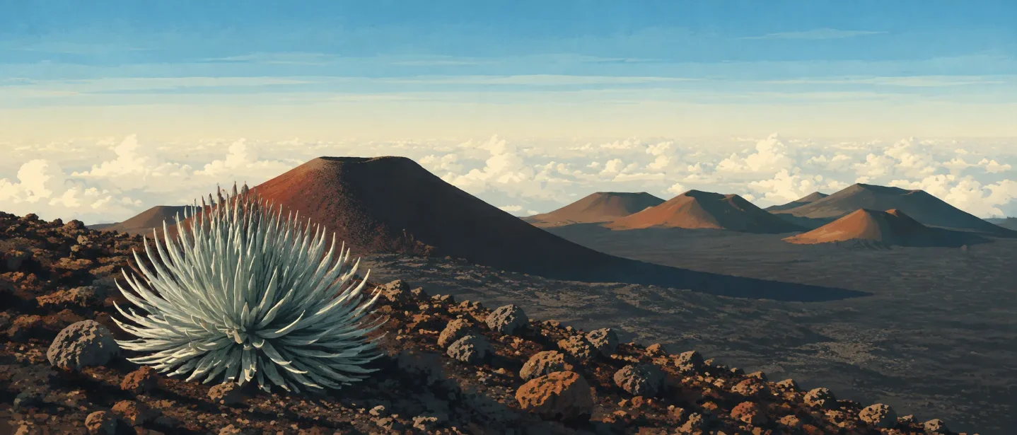
Mauna Kea field guide: māmane forest, silversword, and a 13,803-foot summit
A practical Mauna Kea guide from māmane woodland to alpine cinder desert, with palila and wēkiu bug cues, route choices, seasonal access, and the altitude risks that a short road cannot remove.

The summit is only one part of Mauna Kea’s field guide. The mountain’s more useful story runs from dry māmane woodland at the Visitor Information Station to alpine shrubland, grass desert, and finally a stone desert of cinder cones and lichens. The short drive to the top also creates a serious altitude problem: the VIS sits at 9,200 feet, while the summit is about 13,800 feet. 12
That makes the practical question less about mileage than about exposure, acclimatization, weather, and which objective you actually want. A summit-road visit, the Lake Waiau walk, and the eight-hour hike from the VIS are three different days on the same mountain.
At a glance
| Field note | What to know |
|---|---|
| Mountain | Mauna Kea is a post-shield volcano on Hawaiʻi Island. The U.S. Geological Survey says it last erupted about 4,600 years ago and lists the current alert level as Normal. 1 |
| Elevation | Use 13,803 feet / 4,207 metres as the headline summit elevation. Official University of Hawaiʻi visitor pages use 13,796 feet, a difference of only a few feet caused by the source and rounding. 13 |
| Access baseline | The Visitor Information Station is at 9,200 feet / 2,804 metres. Visitors heading higher should stop there, read the current advisories, and acclimate for at least 30 minutes. 24 |
| Difficulty | The VIS-to-summit hike averages 8 hours round trip—about five hours up and three down—with no restrooms or rest areas along the wilderness route. Rate it Strenuous, before adding altitude and weather. 3 |
| Signature species | Māmane, Mauna Kea silversword, ʻōhelo, pūkiawe, palila, and the summit-dwelling wēkiu bug. 56 |
| Best planning window | For road access, the Maunakea Weather Center says closures are uncommon from April 1 through November 30. That is a planning window, not a promise: ice, snow, high wind, poor visibility, or another unsafe condition can close the road on any date. 7 |
The access road is a steep, rough eight-mile climb above the VIS. A dependable 4WD vehicle is required, and the road can be closed after snow or when wind and visibility cross the posted safety thresholds. 4
The elevation story: forest, shrubland, then stone
This is not a single clean line where one forest ends and another begins. On Mauna Kea, plant diversity, density, and size decline as you climb. The bands below are a field-reading aid built from the official vegetation descriptions, not hard contour boundaries. 5
| Elevation / position | Vegetation zone | What to look for |
|---|---|---|
| Around Halepōhaku and the VIS, 9,200 feet | Dry high-elevation woodland and open shrub-grass patches | Māmane trees, native alpine hairgrass and pili uka, ʻāheahea, pūkiawe, and nohoanu. Fog drip under māmane helps supply moisture in this dry environment. 25 |
| Just above treeline, about 9,800 feet | Alpine shrubland | Low-growing pūkiawe, ʻōhelo, and Mauna Kea dubautia, with scattered grasses and ferns. The plants are built for wind and cold; they do not form a walkable meadow. 5 |
| Higher alpine slopes | Grass desert | Short, sparse vegetation interrupted by volcanic soil and rock. The transition is gradual, so look for decreasing plant height and more exposed ground rather than a single treeline marker. 5 |
| Summit cinder cones, about 13,800 feet | Alpine stone desert | Lichens and mosses dominate the summit’s plant-like cover. The University of Hawaiʻi page records 21 lichen species, including species endemic to Maunakea. 5 |
The elevation gain from the VIS to the summit is only about 4,600 feet, but the route crosses a sharp environmental threshold. The VIS is already higher than most people live, and the summit has roughly 40% less available oxygen than sea level. 3
Plants worth slowing down for
Māmane is the plant that ties the lower high-elevation forest to Mauna Kea’s wildlife story. Its yellow flowers and small trees are easy to miss beside the scale of the volcano, but its seedpods support the palila. Under the trees, fog drip creates a pocket of moisture where grasses and shrubs gather. 5
Mauna Kea silversword, or ʻāhinahina, belongs to the alpine shrubland. Its silver leaves reflect the hard light of the summit and make it one of the mountain’s most recognizable plants. It is rare, so the correct viewing method is from the trail or durable ground—not by stepping across the surrounding cinder. 5
Above treeline, the smaller plants carry the scene: pūkiawe, ʻōhelo, Mauna Kea dubautia, nohoanu, Hawaiian bentgrass, and scattered ferns. The summit stone desert changes the visual scale again. Here, the slow-growing organisms on the rocks matter more than any tall plant. 5
Wildlife: māmane birds below, cinder specialists above
The palila is the clearest reason to treat Mauna Kea’s lower high-elevation forest as habitat rather than scenery. The State of Hawaiʻi describes the bird as critically endangered and endemic to Hawaiʻi; more than 90% of its diet comes from māmane, and its remaining population is confined to a small part of Mauna Kea. 6
The University of Hawaiʻi also lists native birds, the Hawaiian hoary bat, and native arthropods in the māmane woodlands. The alpine zone is much quieter. A Hawaiian petrel has occasionally been observed in subalpine and alpine habitat, but the summit’s regular story is its cold-adapted invertebrate community. 5
The wēkiu bug is the memorable summit specialist. It lives in cinders, where it scavenges or preys on dead and dying arthropods carried upward by wind. It is about the size of a grain of rice, so the mountain may be hosting its most distinctive animal without giving you a visible wildlife moment. 5
Pick the objective before you pack
| Objective | What the official information establishes | Practical rating |
|---|---|---|
| VIS, silversword garden, and short local walks | The VIS provides safety information, restrooms, and short hiking routes at 9,200 feet. The station is the right first stop for acclimatization and current conditions. 24 | Easy walking, high-altitude exposure. Good for an ecology-focused visit without a summit hike. |
| Lake Waiau from Park 3 | The official visitor page describes a roughly two-thirds-mile, 30-minute one-way walk from Park 3. The lake is a sacred site in Hawaiian culture. 3 | Easy by distance; serious by setting. Stay on the designated trail and treat the site respectfully. |
| VIS to the summit on foot | The average round trip is 8 hours, with about five hours up and three down. The route has no rest areas or restrooms, limited phone service, and no public transport. 3 | Strenuous. Start early, acclimate, carry enough water and insulation, and turn around before a small problem becomes an evening emergency. |
| Summit road to the upper facilities | 4WD is required above the VIS. The summit access road is designated for travel, but visitors are asked not to hike to or around the true summit, Puʻuwēkiu, which is a sensitive cultural area. 48 | Low mileage, high consequence. The road removes much of the elevation gain from your legs, not from your body. |
Hikers must register and stay on designated trails. The official list includes the Humuʻula Trail, Summit Access Road, Lake Waiau trails, and Poliahu. That rule protects both visitors and the fragile alpine ground. 8
Best season and access checks
A late-spring-through-fall trip gives you the best chance of a usable road, but Mauna Kea does not have a simple summer guarantee. The Weather Center reports very few road closures from April 1 through November 30, while also warning that snow can fall in summer and that high wind, ice, or visibility below 50 feet can close the summit road. 7
Before leaving town, check the road page and the VIS. The latest road-condition bulletin retrieved for this issue reported the summit road open to 4WD traffic, but that status is temporary. Vehicles are screened for 4WD capability, cleanliness, and fuel; muddy vehicles can be turned away to reduce the spread of invasive species. 47
At the VIS, wait at least 30 minutes before going higher. Do not continue if you have symptoms of altitude sickness; the official guidance is to descend immediately for serious symptoms. Bring winter clothing even in warm months, protect your eyes and skin from strong solar radiation, and carry water because the summit air is extremely dry. 4
The mountain also asks for a narrower kind of preparation: no pets above the VIS except permitted service or hunting dogs, no drones, no camping, and no removing or moving natural material. Respect the request to view Puʻuwēkiu from a distance. Mauna Kea’s most fragile field marks—the silversword, lichens, and cinder-dwelling wēkiu bug—depend on visitors leaving the ground intact. 48
The field-guide takeaway
Mauna Kea is easiest to misunderstand when the road makes the summit look effortless. The ecology is compact but not simple: māmane woodland supports palila at the VIS, alpine shrubs and silversword occupy the band above treeline, and lichens and wēkiu bugs survive among summit cinders. The hike from the VIS is an eight-hour wilderness outing, while the summit-road visit is a short-walking, high-altitude exposure day.
Choose the objective first. For a broad ecological read, stop at the VIS and walk only where the official trail system allows. For Lake Waiau, add cultural respect to the short distance. For the summit hike, plan around acclimatization, daylight, water, insulation, and a weather forecast that can still lose to the mountain.
References
- 1
- 2
- 3Important Things to Know - University of Hawaiʻi at Hilo
hilo.hawaii.edu
- 4
- 5Flora and Fauna of Maunakea - University of Hawaiʻi at Hilo
hilo.hawaii.edu
- 6Palila - Restore Mauna Kea - State of Hawaiʻi
dlnr.hawaii.gov
- 7Maunakea Weather Center - Maunakea Road Conditions
mkwc.ifa.hawaii.edu
- 8Activities and Permits - University of Hawaiʻi at Hilo
hilo.hawaii.edu
This story was produced automatically by a channel. One sentence is all it takes for Neodrop to keep producing for you.