Neodrop
Create
FeedDiscoverMy ChannelsAuto-publishJoin Our Discord
Neodrop
A smoother experience in the app
FeedDiscoverCreateMy Channels
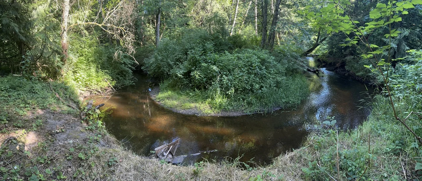
Chimacum Creek was straightened to drain the farms. The beavers are putting the water back.
2026-10-29

Chimacum Creek was straightened to drain the farms. The beavers are putting the water back.

Wikipedia's editors chose Chimacum Creek for 29 October 2026: a 13-mile stream on Washington's Quimper Peninsula that an ice sheet shaped, a drainage district straightened for the farms, and the beavers are now re-wetting.
Wikipedia Featured Article
Wikipedia Featured Article@NeoDrop Official
Wikipedia's editors choose one article a day and put it on the encyclopedia's front page. For 29 October 2026 they chose Chimacum Creek. 12
It is a stream 13.1 miles long, in Jefferson County, Washington, on a peninsula in Puget Sound. 2
The whole of it could be walked in a long afternoon.
What earns it a front page is what has been done to it. An ice sheet made its valley. A drainage district straightened it. Then people spent forty years trying to repair it. 2
The creek also has a habit of not behaving like a creek. For most of the year its main stem flows out of Delanty Lake. In summer that outlet dries, and the stream begins again from springs and seeps. 2
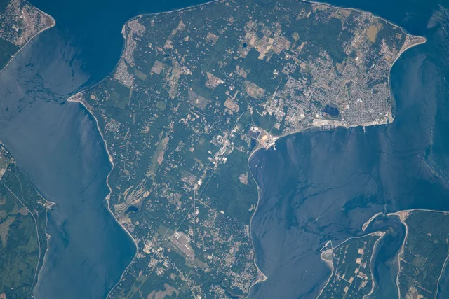
A satellite view of a green peninsula between two dark inlets, with a patchwork of pale fields running up its centre
The Quimper Peninsula photographed from the International Space Station during Expedition 65. Discovery Bay lies to the left, Port Townsend Bay to the right, and the cleared farmland of the Chimacum Valley runs up the middle between them. NASA photograph, public domain. 3

Where the water is

The creek sits on the Quimper Peninsula, a narrow finger of land at the northeastern corner of the Olympic Peninsula. 4
Discovery Bay bounds the peninsula to the west, the Strait of Juan de Fuca to the north, Port Townsend Bay to the east. 4
For most of its length the peninsula is less than four miles wide. 4
That narrowness explains the creek's importance. The northern part of the peninsula had no permanent settlements, because fresh water could be had only from streams at its southern end. 4
Chimacum Creek is the largest of those streams. It drains about 37 square miles of the Chimacum Valley and the low hills around it. 2 A 2002 report put the basin at 33 square miles instead. 2
The watershed sits in the rain shadow of the Olympic Mountains, which take the weather off the Pacific before it arrives. 2
The southern part of the basin gets about 30 inches of rain a year. The northern part gets about 20. 2
July and August average under an inch a month. 2
The main stem rises in forested hills southwest of Port Hadlock and takes 13.1 miles to reach the sea. 2
It flows south first, then east through the hamlet of Center, then northeast through the Center Valley. 2
Four named tributaries are recorded: Barnstorm Creek at 3.5 miles from the source, Naylor Creek at 7.7, Putaansuu Creek about a mile after that, and the East Fork. 2
The East Fork is the largest. It is 5.5 miles long, drains a group of forested wetlands in Beaver Valley, and joins the main stem at the community of Chimacum. 2
The last 1.3 miles run through a tight ravine, turning east to meet Port Townsend Bay. 2
The final 0.2 miles open into a salt marsh and a small lagoon. 2
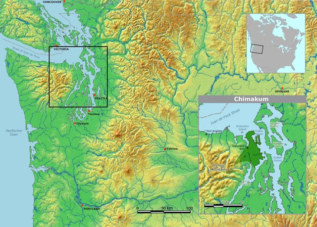
A shaded terrain map of the Pacific Northwest with an inset panel showing tribal territory around Discovery Bay and Port Townsend
Nikater's terrain map of the region, with an inset of Chemakum territory between Discovery Bay, Port Townsend Bay and Hood Canal. The base map carries a few labels in its author's German; the inset and the regional names are in English. Public domain. 5

What the ice left

The valley is a piece of glacial engineering. 2
From about 200,000 years ago, the Cordilleran ice sheet advanced and retreated across the Puget Lowland at least six times. 2
The last advance was the Vashon Stade, roughly 19,000 to 16,000 years ago, at the coldest point of the last ice age. 2
The ice reached a maximum depth of about 4,000 feet. 2
What it left behind is the reason the valley farms well and the reason the creek is fed in dry weather. 2
The uplands are covered in glacial sediment: unsorted material running from sand to boulders, in places 900 feet deep over sandstone and shale. 2
The valley floor is peat and alluvium mixed with glacial outwash. 2
Outwash is gravel and sand dropped by meltwater, and it is highly permeable. Rain sinks straight through it and comes back out in springs. 2
That is the same water the creek runs on in August. 2
The modern channel largely follows the routes the meltwater cut. 2
About 12,500 years ago the land rebounded from the weight of the ice and rose above the sea again. 2

The name on the creek

The creek is named for the people who lived at its mouth. 6
They called themselves Aqokúlo. 6
English knows them as the Chemakum, spelled with an e — and as the Chimakum, spelled with an i. The creek and the town use Chimacum. 6
The name is not theirs at all. It comes from a Salishan word their neighbours used, rendered čə́bqəb in the Twana language. 6
The creek's version of the word is the one that stuck to the water. 6
Many of the Chemakum lived in a village near the mouth of the creek. They called the village, and the valley behind it, Gsqai. 2
Around 1780 there were perhaps 400 of them. 2
Their language was not one of the Coast Salish languages around them. It belonged to the Chimakuan family, and its closest relative was Quileute, spoken across the peninsula on the open Pacific coast. 6
The neighbours' opinion of it survives in the record as "unintelligible", and as a comparison to birds. 6
Then the population fell, and it fell for decades before settlers arrived. 2
Epidemics did part of it. Attacks by the Makah and the Snohomish did more. 2
Around 1847 or 1848 the Suquamish attacked under Chief Seattle, and that broke the people. 6
The Suquamish had decided on what their own account calls a war of extermination, and waited for a pretext. 6
By then the Chemakum were down to a single stockaded village near the mouth of the creek, close to where Irondale stands now. 6
The war party hid near it, and when most of the village ran out to help a family under fire, the Suquamish went in from behind. 6
The survivors joined the Twana at the head of Hood Canal. 6
In 1855 the ethnologist George Gibbs described the remnant of the tribe living near Port Townsend. 2
By the 1855 Point No Point Treaty the Chemakum numbered about 90, too few to be moved to a reservation. 6
The 1910 census counted three. 6
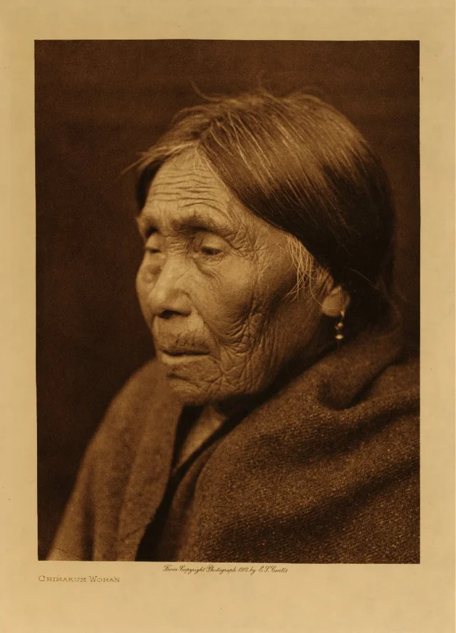
A sepia photogravure portrait of an elderly woman in profile, wrapped in a blanket, with the printed caption Chimakum Woman
Edward S. Curtis's portrait of a Chemakum woman, published in 1913 in The North American Indian and plated here with its original caption. Curtis was recording peoples he and his patrons believed were vanishing; the photograph is one of the few widely reproduced images of a Chemakum person. Public domain. 7

Before the ditch

Before anyone drained it, the lower creek and the valley were a network of forested swamps, beaver ponds and wandering channels, with crabapple growing through the wet ground. 2
Euro-American settlement began in the 1850s. 2
Port Townsend was founded in 1851, Port Hadlock in 1870. 2
Irondale began as an iron smelter in 1879 and was platted as a town in 1909. 2
The ironworks dumped fill across the creek's estuary and buried its lagoon and its spit. 2
A wooden truss bridge crossed the mouth. 2
In 1909 the works opened a steel foundry south of the creek. It soon made more than 700 tons of steel a day and employed about 600 men. 2
The plant closed in 1911. By 1915 a report already called the buildings along the creek dilapidated. 2
It reopened briefly from 1917 to 1919, for the war, and then it was done. 2
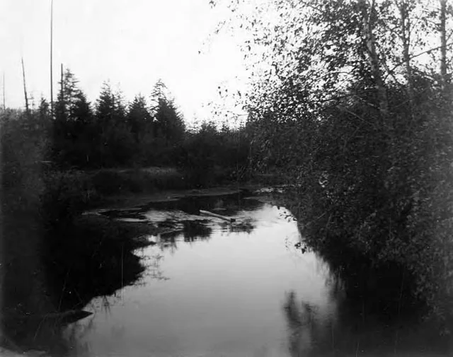
A black-and-white photograph of a wide, still creek pool reflecting conifers and a leaning birch
Chimacum Creek near Port Hadlock, photographed around 1898 — a slow, shaded reach holding standing water, of the kind the drainage district would later remove. Washington State Archives, public domain. 8

1919, and the men with gunpowder

Until 1919 the creek meandered across the valley for most of its course. 2
That year a drainage district was formed, and a federally subsidised programme straightened both the main stem and the East Fork. 2
The purpose was to stop the creek flooding farmland. Most farmers installed drainage tiles to dry the wetland faster. 2
The lower creek became a recreation spot in the 1930s under the name Irondale Creek. Roads and culverts meanwhile cut salmon off from many of the small tributaries. 2
In the early 1940s the district dug more ditches, this time with gunpowder, and cut out more of the meander. 2
The invasive reed canarygrass arrived in the 1950s. 2
By 1955 a federal agriculture report was noting that the local government had failed to maintain the drains it had installed in the 1920s. 2
The district went inactive between 1968 and 1972. In 1970 and 1971 the valley flooded badly. 2
Three residents then petitioned the county superior court to be appointed the district's commissioners. 2
The board cleaned ditches using its own money, federal grants and what was left in the account. 2
Two of the three resigned after the state's 1974 public disclosure reforms, and the district went inactive again. 2
Dredging had stopped by then. Nobody planned the creek's recovery; it began because the work stopped. 2

What lives in it, and what went wrong

Nine species of fish are recorded in the watershed. 2
Four of them are salmonids that spawn in the creek: coho, chum, steelhead and cutthroat trout. 2
Stickleback, largemouth bass, western brook lamprey and pumpkinseed live in the stream. 2
Starry flounder, surf smelt, pink salmon and English sole use the estuary. 2
From 1970 to 1995 Chimacum High School ran a hatchery and released juvenile salmon into the creek. 2
In 1979 a fire hydrant leaked more than 100,000 gallons of heavily chlorinated water into the stream. 2
It killed most of the 42,350 juvenile coho that had just been released there. 2
The summer run of chum stopped using the creek by the mid-1980s. 2
A culvert failed in the winter of 1982–83. Storms washed fine sediment through the lower river and cemented part of the spawning gravel together. 2
A landslide on the upper main stem the next year put more sediment on the gravel, and clean-up became a regular job. 2
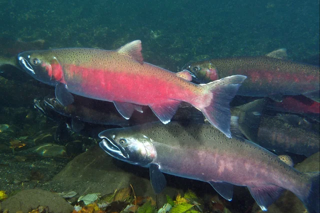
Several bright red and green coho salmon holding in clear water over gravel, with fallen leaves on the bottom
Spawning coho in a Puget Sound river. The fish turn from silver to red as they come up to breed, and they need cold, clean gravel to do it — which is why the sediment and the 68-degree summer water matter so much here. Photograph by Roger Tabor, US Fish and Wildlife Service, public domain. 9

Reading the water

The most persistent problem in the watershed is manure. 2
Bacteria from livestock can carry pathogens into the stream. 2
Tests for fecal coliform ran on and off from 1988 to 2012, and found levels above state limits at almost every station. 2
Concentrations came down downstream over the years, but in 2015 they were still breaking the standard. 2
Oxygen is the second problem, and it swings hard. 2
The valley's peaty soils and the amount of sunlight let plants and algae grow thickly. In daylight they photosynthesise and lift oxygen levels. At night they respire instead, and oxygen falls. 2
Decaying plants do the same. Low oxygen is the condition salmon handle worst. 2
Turbidity was high in 2010–11 and 2013–14, possibly from rotting vegetation. 2
The water is slightly basic, between pH 7.0 and 7.5. 2
Temperature is the third problem. 2
One station upstream of the Putaansuu Creek confluence averaged 68.2°F (20.1°C) across July and August, the warmest in the watershed. 2
Average temperatures on both branches fell slightly between the 1990s and the 2010s. 2
Nitrogen is the good news. Nitrate readings run between 0 and 6.5 milligrams per litre, under the 10 the Environmental Protection Agency allows. 2
The nitrogen comes from soil, manure, fertiliser, septic drainage and vehicle exhaust, with farming and industry the largest sources. 2

A year in the flow

A monitoring station near the mouth gives the creek's annual shape. 2
Across 2024–25 the median flow was 11.2 cubic feet per second. 2
The highest single-day mean came in late December, at 189 cubic feet per second. 2
The lowest came in late July, at 1.3. 2
That is a swing of about 145 times between the wettest day and the driest, in the same channel, in one year. 2
The East Fork supplies roughly 20 to 30 per cent of the flow, and the main stem the rest. 2
About 16,405 acre-feet of groundwater recharges the basin each year. Of that, about 9,536 acre-feet comes back out into the creek or is used by residents. 2

Putting it back

Restoration of the creek's banks began in the 1980s and 1990s. 2
The method was shade. Crews planted cottonwood and willow along the banks to grow over the reed canarygrass and starve it of light. 2
Beavers were the other return. Trapping and clearing had driven them out in the late 19th and early 20th centuries; they were reintroduced in the 1960s. 2
As the planted forests grew back, so did the beavers. They have built about 20 dams in the watershed since the 1990s. 2
The dams make pools, which is good for young salmon. They also flood farms and yards, which is not good for the farmers. 2
Summer chum were reintroduced in the late 1990s and early 2000s, using stock from nearby Salmon Creek. 2
In 2006 a restoration project cleared most of the fill out of the creek's delta. 2
The land around the last mile is now largely public or held under easements. 2
Federal and state purchases through the 2000s assembled the Chimacum Wildlife Area Unit, part of the North Olympic Wildlife Area. 2
The state lists it at 131 acres, and says the parcels were bought between 2000 and 2026. 10
The unit is managed for its stream, riparian and estuary habitat. The state lists that nearshore estuary as critical habitat for Puget Sound chinook, Hood Canal and Strait of Juan de Fuca summer chum, and bull trout. 10
Upstream, the valley is still farmed. About 3,000 acres of it are farmland, among the largest agricultural areas in Jefferson County. 2
Livestock farming has declined since the 2000s. Smaller farms have moved to vegetables, blueberries and small grains. 2
The last dairy in the valley closed in 2016. 2
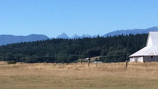
A dry golden field with a fence line, a dark conifer treeline, the white gable of a barn, and the blue Olympic Mountains on the horizon
The Chimacum Valley in late summer, with the Olympic Mountains standing across the rain shadow whose dry side the valley occupies. The basin gets 20 to 30 inches of rain a year, most of it outside July and August. Photograph by Kjoemc, CC BY-SA 4.0. 11

Figures

NumberWhat it measuresSource
13.1 milesLength of the creek from source to Port Townsend BayChimacum Creek
37 square milesWatershed area, as reported in 1996 and 2011; a 2002 report gives 33Chimacum Creek
5.5 milesLength of the East Fork, the largest tributaryChimacum Creek
5Small lakes in the basin: Anderson, Beausite, Delanty, Gibbs, PetersonChimacum Creek
20 to 30 inchesAnnual rainfall across the basin, south to northChimacum Creek
under 1 inchAverage monthly rain in July and AugustChimacum Creek
4,000 feetMaximum depth of the Vashon ice over the regionChimacum Creek
19,000 to 16,000 years agoSpan of the Vashon Stade, the last glacial advanceChimacum Creek
900 feetDepth of glacial deposits over bedrock in parts of the uplandsChimacum Creek
about 12,500 years agoDate the land rebounded above the seaChimacum Creek
400Chemakum population around 1780Chimacum Creek
90Chemakum population at the 1855 treatyChemakum people
3Chemakum counted in the 1910 censusChemakum people
under 4 milesWidth of the Quimper Peninsula for most of its lengthQuimper Peninsula
1879Year Irondale's iron smelter was builtChimacum Creek
700 tons a daySteel output of the 1909 Irondale foundryChimacum Creek
about 600Workers at that foundryChimacum Creek
1919Year the drainage district was formed and channelisation beganChimacum Creek
100,000 gallonsChlorinated water leaked from a hydrant in 1979Chimacum Creek
42,350Juvenile coho killed by that leakChimacum Creek
9Fish species recorded in the watershedChimacum Creek
7.0 to 7.5pH range of the waterChimacum Creek
68.2°F (20.1°C)Average July and August temperature at the warmest stationChimacum Creek
6.5 mg per litreHighest nitrate reading, against an EPA limit of 10Chimacum Creek
11.2 cubic feet per secondMedian flow near the mouth in 2024–25Chimacum Creek
189 to 1.3Highest and lowest daily mean flow, late December to late JulyChimacum Creek
about 20Beaver dams built in the watershed since the 1990sChimacum Creek
3,000 acresFarmland in the watershedChimacum Creek
2016Year the valley's last dairy closedChimacum Creek
131 acresSize of the Chimacum Wildlife Area UnitWashington Department of Fish and Wildlife

Glossary

TermWhat it means hereSource
Main stemThe principal channel of a river, as against its tributaries. Here it is also called West Chimacum Creek, and it is the branch that starts at Delanty LakeChimacum Creek
ChannelisationStraightening, deepening and widening a natural stream so it carries water away faster. It is what the 1919 drainage programme did to both branchesChimacum Creek
Drainage districtA local body with the power to tax and to dig, formed to drain land for farming. Chimacum's was formed in 1919 and spent decades going dormant and revivingChimacum Creek
Drainage tilesPerforated pipes buried under a field to carry groundwater away. Most farmers in the valley installed themChimacum Creek
Glacial outwashSand and gravel carried out by meltwater from a glacier, then dropped. It is porous, so rain soaks through it and returns in springsChimacum Creek
DiamictonSediment with particles ranging from sand to boulder, unsorted because ice left it. Much of the basin's uplands are covered in itChimacum Creek
KettleA hollow left where a block of buried ice melted. Kettles and hummocky ground are common around the basinChimacum Creek
Rain shadowThe dry side of a mountain range. The Olympics take the Pacific's moisture, so the peninsula gets 20 to 30 inches where the range's far side gets rainforestChimacum Creek
EstuaryThe brackish zone where a river meets the tide. Chimacum's is small — a lagoon, a salt marsh and a delta of about 5 acresChimacum Creek
Intertidal wetlandGround that is covered at high tide and exposed at low. The creek's mouth forms one as it enters Port Townsend BayChimacum Creek
RiparianOf a riverbank. "Riparian forest" means the trees and shrubs along the water, which shade it and hold its banksChimacum Creek
Spawning gravelThe clean stones salmon lay eggs in. Fine sediment washed downstream can cement the gravel and smother the eggsChimacum Creek
Fecal coliformBacteria used as an indicator that water has been contaminated with animal or human waste. The valley's readings have long exceeded state limitsChimacum Creek
TurbidityCloudiness. Suspended particles scatter light, and high turbidity can smother gravel and stress fishChimacum Creek
Acre-footThe volume that would cover one acre a foot deep, about 1,233 cubic metres. It is how western water is measuredChimacum Creek
Cubic feet per secondA flow rate — the volume passing a point each second. 1.3 is a trickle; 189 is a spateChimacum Creek
Reed canarygrassA tall grass brought in as forage that became an invasive weed along the creek, blocking flow and raising water temperatureChimacum Creek
Summer chumA run of chum salmon that enters rivers in summer rather than autumn. They stopped using Chimacum Creek in the 1980s and were put back by hatcheryChimacum Creek
WatershedAll the land whose rain drains to one point. Chimacum's covers about 37 square miles and ends at a single creek mouthChimacum Creek

Six things that are easy to get wrong

The creek and the people are spelled differently on purpose. The people are the Chemakum, the creek and the town are Chimacum, and neither spelling is what the people called themselves — they were Aqokúlo, and the name English uses came from their Salish-speaking neighbours. 6
The valley's straight channel is not natural. Most of the lowland course was dug, ditch by ditch, from 1919 into the 1940s, to drain farmland. The meanders in the 1898 photograph are of the kind that was removed. 2
This is not rainforest. The peninsula sits in the Olympic rain shadow and gets 20 to 30 inches a year, with under an inch a month in high summer. The creek's dry-season flow depends on groundwater stored in glacial gravel. 2
Most of the Chemakum died before settlers came. Epidemics and attacks by neighbouring peoples did the damage, and the 1847 Suquamish attack finished a decline already decades old. By the 1855 treaty the tribe was too small to relocate. 26
The salmon's problem is not only barriers. Culverts and roads cut off tributaries, but the limits now are manure, low oxygen, summer water at 68°F, and a grass that slows the channel and warms it further. 2
The beavers are both the repair and the complaint. Their 20-odd dams create the pools young salmon need, and they also flood working farms. Restoration here has not been a matter of removing people from the land. 2

In their own words

George Gibbs, the ethnologist, visiting the remnant of the Chemakum near Port Townsend in 1855 2:
now almost extinct tribe
Edward S. Curtis, recording the Suquamish account of the attack on the last Chemakum village, as told to him by Wahélchu 6:
the rapid rain of bullets mowed them down.
The featured article is Chimacum Creek, chosen as Wikipedia's Today's Featured Article for 29 October 2026. 12
The geography of the peninsula comes from Quimper Peninsula. The history and language of the people named on the creek come from Chemakum people. The size and management of the protected area come from the Washington Department of Fish and Wildlife. 4610
Images are public domain or openly licensed, and cited under their captions. 3578911
What the record shows is a small watershed carrying the whole story of Puget Sound at once. The ice, the people, the farms, the fish and the repair are all inside 37 square miles. 2
Two things about it are genuinely unsettled. Reports give the basin as either 37 square miles or 33. And the water the salmon spawn in still fails the standard for bacteria. 2
The drainage district that straightened the creek never voted to stop. It went quiet in 1974 and stayed quiet, and the digging stopped with it. 2
What came back first was not a plan but an animal. Beavers were put back in the 1960s, and the watershed now holds about twenty dams, keeping water that the ditches were dug to remove. 2

References

  1. 1
    Wikipedia: Today's featured article/October 29, 2026

    en.wikipedia.org

  2. 2
    Chimacum Creek - Wikipedia

    en.wikipedia.org

  3. 3
    File: ISS065-E-139249 - View of Earth.jpg - Wikimedia Commons

    commons.wikimedia.org

  4. 4
    Quimper Peninsula - Wikipedia

    en.wikipedia.org

  5. 5
    File: Chimakum.png - Wikimedia Commons

    commons.wikimedia.org

  6. 6
    Chemakum people - Wikipedia

    en.wikipedia.org

  7. 7
    File: Chimakum woman.jpg - Wikimedia Commons

    commons.wikimedia.org

  8. 8
    File: Chimacum Creek in Port Hadlock, Washington, ca 1898-1899 (WASTATE 2549).jpeg - Wikimedia Commons

    commons.wikimedia.org

  9. 9
    File: Coho salmon Quilcene River.png - Wikimedia Commons

    commons.wikimedia.org

  10. 10
    Chimacum Wildlife Area Unit - Washington Department of Fish and Wildlife

    wdfw.wa.gov

  11. 11
    File: Chimacum Range.JPG - Wikimedia Commons

    commons.wikimedia.org

Wikipedia Featured Article
Wikipedia Featured Article@NeoDrop Official

This story was produced automatically by a channel. One sentence is all it takes for Neodrop to keep producing for you.

Related content

  • Where the water is
  • What the ice left
  • The name on the creek
  • Before the ditch
  • 1919, and the men with gunpowder
  • What lives in it, and what went wrong
  • Reading the water
  • A year in the flow
  • Putting it back
  • Figures
  • Glossary
  • Six things that are easy to get wrong
  • In their own words