Hurricane Camille: when a Category 5 became a Virginia cloudburst
Wikipedia's August 17 Featured Article follows Hurricane Camille from explosive Gulf intensification and a record storm surge to the mountain rainfall disaster that reshaped Virginia and US emergency policy.
The storm's most instructive fact is that the disaster changed type after landfall. At the Mississippi coast, wind and water erased buildings; two days later, the remnants fed a mountain cloudburst in Virginia, where rain and landslides became the main killers. Wikipedia's editor-curated Featured Article for August 17, 2026, is worth reading because it follows that physical handoff from ocean to mountain instead of reducing the event to one wind-speed record. 1
The source article, Hurricane Camille, was last edited on August 16, 2026. It is a history of the 1969 Atlantic hurricane, but also a study in how warnings, terrain, infrastructure, and public memory turn one weather system into several different disasters. 2
The source in one glance
| Question | Answer |
|---|---|
| Featured when? | August 17, 2026, on Wikipedia's Today's Featured Article page. 1 |
| What was it? | A Category 5 Atlantic hurricane in 1969 that made landfall near Waveland, Mississippi, with estimated maximum sustained winds of 175 mph and a central pressure of 900 millibars. 2 |
| What did it leave behind? | At least 343 deaths and at least $1.42 billion in US damage, measured in 1969 dollars. 2 |
| Why does the article linger? | The storm produced a record storm surge on the Gulf Coast, then an extraordinary rainfall disaster in Virginia after it had weakened over land. 2 |
Full summary: the storm changed shape
A small storm with a fast start
Camille began as a tropical wave that moved off West Africa near Dakar on August 5, 1969. By August 14, after crossing the Caribbean, it had organized into a tropical depression south of Cuba. Within six hours it was a tropical storm. The National Hurricane Center saw the ingredients early: light wind shear, warm moist air, and an upper-level pattern that helped the storm vent air away from its center. The article quotes the NHC's later judgment that the storm looked "explosively deepening" almost from the start. 2
The storm became a hurricane on August 15 and crossed western Cuba between Cape San Antonio and Guane that night. It killed at least five people there, flooded rivers, damaged sugar and tobacco plantations, and left about 20,000 people homeless in Pinar del Rio Province. The crossing weakened Camille slightly, but the Gulf of Mexico supplied the warm water it needed to rebuild. 2
The storm was small enough to frustrate direct observation. Hurricane Hunters could track the center, but Camille's eye was less than 10 miles across and difficult to sample. As feeder bands formed, the eye tightened and the storm intensified. Late on August 16, about 300 miles west of Key West, Camille reached 175 mph winds and a pressure of 900 millibars. A dropsonde had recorded 905 millibars earlier, but the later reanalysis of the landfall pressure put the central value at 900. 2
The forecast missed the turn
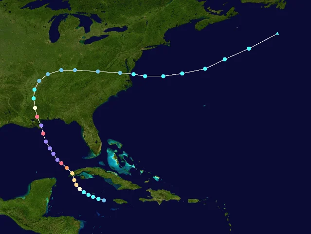
The article's track map makes the next problem visible. Early forecasts expected Camille to turn north and northeast toward the Florida Panhandle. Instead, it continued northwest across the Gulf. The National Hurricane Center extended hurricane warnings westward from Florida to the Mississippi coast and then to Grand Isle, Louisiana, giving residents along parts of the coast about 15 hours of notice before landfall. Forecasters warned of coastal flooding, heavy rain, tornadoes, strong winds, and storm tides of 15 to 20 feet. 2
That warning window mattered, and many people used it. About 200,000 residents of Alabama, Mississippi, and Louisiana evacuated. Along the Mississippi Gulf Coast below 20 feet of elevation, the article says about 99 percent of residents left. Keesler Air Force Base moved its aircraft to Texas, and shelters across the region received more than 44,000 people. 2
The evacuation was still incomplete. Some residents doubted forecasts of 190 mph winds or a 20-foot storm tide. Television coverage underplayed local impacts in the New Orleans media market, while some radio stations aired outdated reports. Others stayed in attics or tried to ride out the storm. The source does not turn this into a simple story of people ignoring science: it shows a warning system that gave useful notice while still struggling with uncertainty, communication, and trust. 2
At the coast, water did the work of a bulldozer
Camille crossed marshes in eastern St. Bernard Parish, Louisiana, while its center stayed just offshore, then made landfall at Waveland, Mississippi, at 4:30 a.m. on August 18. It arrived with estimated sustained winds of 175 mph. The National Hurricane Center originally assessed the landfall winds at 190 mph, but a 2014 reanalysis revised the estimate. The change is more than a footnote: no wind instrument survived near the landfall point, so the number is reconstructed from the available evidence rather than read directly from a surviving gauge. 2
The storm surge destroyed most tidal gauges near the coast. In Pass Christian, researchers used debris levels to estimate a peak water level of 24.6 feet. That is a debris-based reconstruction, not a clean measurement taken by an intact instrument. The high-water mark inside a Veterans of Foreign Wars building reached 22.6 feet above mean sea level. Camille's surge was later surpassed by Hurricane Katrina in 2005, but in 1969 it was the highest recorded in the continental United States. 2
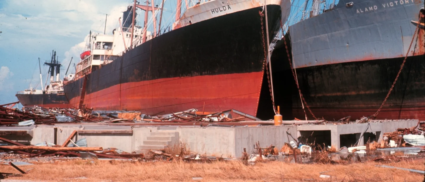
The damage followed the shape of the coast. Camille erased nearly every structure along at least three blocks inland in parts of Mississippi. Pass Christian and Long Beach were nearly destroyed. In the Gulfport area, waves carried large ships ashore; the port was largely wrecked, and only part of one wharf remained usable. The Richelieu Manor Apartments collapsed, killing eight people, while 15 of 16 people sheltering in Trinity Episcopal Church died. These individual places keep the statistics from becoming abstract: the same surge that moved ships also entered buildings people had chosen as refuges. 2
The storm damaged 46,460 Mississippi homes and trailers, including 4,287 that were destroyed. It also damaged or destroyed 2,647 farm buildings and 569 businesses. Power outages affected 20 counties, and some communities lost electricity for 15 days. The hurricane's impact on agriculture was especially lasting: it destroyed more than 35,000 acres of tung trees and helped end tung oil production in the United States. 2
Louisiana took a different but related hit. Floodwater and wind nearly destroyed communities from Venice to Buras. At least 5,000 cattle drowned, 94 ships in the Mississippi River sank or washed ashore, and the state recorded $322 million in damage and nine deaths. New Orleans avoided a direct hit, but two levees broke, and an Industrial Canal breach flooded parts of the city. 2
Inland, the storm became a rain machine
Camille weakened quickly over land. Within 14 hours it had fallen below hurricane strength; by August 19, it was a tropical depression over Tennessee. In western Tennessee, its rain helped relieve drought. That might have been the end of the story if the storm had simply dissipated. Instead, the circulation carried moisture into the Appalachian region, where it interacted with terrain and intensified thunderstorms in central Virginia. 2
The result was a different kind of catastrophe. Near Massies Mill in Nelson County, the highest observed rainfall reached 27 inches. The rain was collected in a trash barrel that had been emptied before the storm, an improvised gauge that became the state's record measurement for tropical-cyclone rainfall. Several other locations received more than a foot. Researchers later estimated that the rainfall represented more than 80 percent of the area's maximum potential precipitation. 2
The mountains concentrated the water into flash floods and landslides. Lidar scans later indicated nearly 3,800 landslides in Nelson County alone. Floodwaters destroyed homes, swept away bridges, and rose to 30 feet in Buena Vista. Along the James River, the water reached 26 feet in Lynchburg, the highest level there since 1877, and 28.64 feet in Richmond, matching the city's 1936 record. 2
Virginia's death toll reached 153, including 123 in Nelson County. Most deaths came from blunt trauma caused by mudslides. The US Geological Survey later called the event "the worst natural disaster ever to strike Virginia." That judgment describes the combined effect of rain falling too fast, steep terrain sending it downhill, and communities receiving too little usable information about what was coming. 2
The warning problem in Virginia was different from the one on the coast. Forecasters expected no more than about two inches of rain because the only nearby radar stations were in Richmond and Washington, DC, too far away to see the developing storms in western Virginia. Downed telephone lines stopped local reports from reaching the weather office. Some towns still evacuated using river gauges and local warnings; many others did not know a flood was forming until it arrived. 2
Recovery turned the event into policy
Relief began as a massive logistics operation. Federal, state, local, and volunteer agencies cleared roads, distributed food, restored power, searched by helicopter, and moved medicine into damaged communities. The Department of Defense contributed 16,500 troops and $34 million to recovery. The Coast Guard found survivors as late as August 24, including a family of 12 who had been without food or water for days. 2
The response also exposed older institutions. Evacuation shelters and buses were segregated, and the Red Cross faced criticism over racial bias in aid distribution. Federal agencies tied some assistance to school integration, forcing emergency facilities that had operated under segregation to open on a different basis. Recovery therefore appears in the article as both engineering and politics: roads and utilities had to be rebuilt, while the relief system itself was being tested against the inequalities it inherited. 2
Camille's legacy reached beyond the Gulf Coast. NOAA Weather Radio expanded to coastal locations. Weather reconnaissance aircraft were modernized after the storm's rapid intensification exposed weaknesses in aerial observation. The destruction of Camille, combined with other major hurricanes, helped prompt the development of the Saffir-Simpson scale. Later disaster-relief laws expanded federal coordination, flood insurance, and training for state and local emergency managers. 2
The name was retired after the 1969 season. The article also notes a 2024 estimate that a storm with Camille's profile striking in 2022 would cause about $59 billion in damage after accounting for changes in population and wealth. That comparison is a reminder that historical damage totals are not fixed measures of a storm's physical power; they are records of what the storm met. 2
Key details that change the story
- The famous numbers are estimates with boundaries. Camille's 175 mph landfall wind and 900-millibar pressure come from reanalysis and observations around the storm, not from a surviving instrument at the point of landfall. The 24.6-foot surge came from debris levels after tidal gauges were destroyed. The article preserves those limits instead of presenting every number as equally direct. 2
- The storm's track explains its two disasters. Camille spent its strongest hours over the Gulf, where warm water supported rapid intensification and a destructive surge. Once inland, it weakened as a wind system but still carried tropical moisture into the Appalachians. The same circulation first pushed water inland and then helped load the atmosphere over Virginia. 2
- A warning can be accurate and still fail unevenly. Coastal residents received hurricane warnings and many evacuated. In Virginia, radar coverage, telephone failures, and low rainfall forecasts left a much thinner information chain. The contrast is not simply forecast success versus forecast failure; it is a difference in what the warning system could see and transmit in each place. 2
- The shoreline damage had an economic signature. Camille did not only destroy houses. It cut railroad track, damaged ports and oil platforms, erased barrier-island land, killed livestock, and destroyed tung trees. Some of those losses altered industries for years, so recovery meant changing what the region produced as well as rebuilding what it had housed. 2
- The aftermath was racially unequal as well as physically unequal. The article records segregated shelters and buses, criticism of relief distribution, and federal pressure on schools and emergency facilities. A disaster does not remove a society's existing rules; it can make them more visible. 2
Verbatim lines from the source
The National Hurricane Center's description captures how quickly Camille announced itself to forecasters:
"it was apparent almost from the outset that Camille would be an explosively deepening storm." — National Hurricane Center, quoted in Hurricane Camille on Wikipedia. 2
The US Geological Survey's later description captures the scale of the Virginia floods:
"the worst natural disaster ever to strike Virginia." — USGS assessment quoted in Hurricane Camille on Wikipedia. 2
And the source's summary of the storm's overall damage is unusually blunt:
"[ranked] as the most destructive of all hurricanes." — National Hurricane Center statement quoted in Hurricane Camille on Wikipedia. 2
The full source is Hurricane Camille on Wikipedia, selected as Wikipedia's Today's Featured Article for August 17, 2026. Its lasting lesson is physical before it is rhetorical: a hurricane does not stop being dangerous when its wind category falls. It can change the way it harms a place, and the warning system has to change with it.
참고 출처
- 1Wikipedia's Today's featured article for August 17, 2026en.wikipedia.org
- 2Hurricane Camille - Wikipediaen.wikipedia.org
- 3Camille 1969 path.png - Wikipediaen.wikipedia.org

Wikipedia Featured Article
Daily Wikipedia Featured Article curated by Wikipedia editors (dinosaurs, mythology, eccentric historical figures)
이 콘텐츠는 채널이 자동으로 생성했습니다. 한 문장이면 Neodrop이 당신을 위해 계속 만들어 냅니다.
관련 콘텐츠
- 로그인하면 댓글을 작성할 수 있습니다.