Three Trails Worth the Drive: August 12–19, 2026
Three current picks for August 12–19: reservation-gated Lake Oesa, storm-and-smoke-sensitive Easy Pass, and the short, waterfall-focused Wapta Falls, with the access checks that decide each trip.
For August 12–19, the best choice depends on the gate you can live with: Lake Oesa has the strongest alpine payoff but requires a Lake O’Hara shuttle reservation; Easy Pass is the hardest U.S. day hike and should start early before afternoon storms; Wapta Falls is the forgiving option, with a short route and a live road-and-trail check.
Quick comparison
| Trail | Difficulty, distance, gain, time | Why go this week | Parking and access | Go/no-go call |
|---|---|---|---|---|
| Lake Oesa, Yoho National Park, British Columbia | Moderate by terrain; 6.4 km return; 240 m gain; plan 3–4 hours. Parks Canada lists 3.2 km one way and 240 m gain but does not publish a difficulty label or time estimate; the moderate classification and time are editorial planning estimates based on the rocky, talus-crossing route. 1 | The trail was rated Good on Aug. 8. Alpine meadows and quartzite cliffs are in season, and Saturday, Aug. 15, is the cleanest weather window in the current forecast. 23 | The day-use shuttle is reservation-only and runs June 19–Oct. 4. It leaves the Lake O’Hara parking lot, 12 km west of Lake Louise or 13 km east of Field. Without a shuttle reservation, the access road is 11 km each way. 4 | Go Aug. 15 or 17 only with a confirmed shuttle reservation. Do not turn up hoping to walk a short approach; the road makes that a 22 km day before Lake Oesa begins. |
| Easy Pass, North Cascades National Park, Washington | Strenuous; 11.9 km return; 914 m gain; plan 5–7 hours. NPS lists 7.4 miles round trip and 3,000 ft gain; it does not publish a duration, so the time is a planning estimate. 5 | The pass route is not listed as closed, and the trail report says down trees were cleared to just past Cosho Camp. The park warned Aug. 5 that wildfire smoke can change quickly. 6 | The trailhead is at milepost 151 on SR 20. NPS says a Northwest Forest Pass or America the Beautiful pass is required to park. The current page does not publish a lot capacity. 7 | Go early on a clear-air day. The Aug. 12 forecast has mostly sunny mornings but afternoon shower and thunderstorm chances; abandon the pass if thunder builds or smoke obscures the route. 8 |
| Wapta Falls, Yoho National Park, British Columbia | Easy; 4.6 km return; about 50–70 m gain; 1–3 hours. These route figures come from a recent hiking guide rather than Parks Canada, whose current status page does not reproduce the route statistics. 9 | Parks Canada rated the trail Good on Aug. 5. The waterfall is the payoff: a short forest walk ends at a broad, high-volume cascade with the Rockies behind it. 2 | Wapta Falls Road was Open Aug. 7, but the current note says no westbound access. The road is seasonal, gravel, and can be rough for small cars; no separate Wapta parking fee is listed. 1011 | Best low-risk pick for Aug. 15–16, after checking the road direction and the forecast. Stay on designated viewpoints: the Aug. 5 report also flags deadfall. |
Lake Oesa, Yoho National Park
6.4 km return · 240 m gain · moderate by terrain · plan 3–4 hours
Lake Oesa is the best choice here if the trip is about alpine scenery rather than mileage. The trail leaves the Lake O’Hara shoreline, climbs switchbacks and rocky steps, crosses talus and scree, then enters delicate meadows framed by copper-coloured quartzite cliffs. The lake sits in tilted rock slabs at the end of the route. 1
Parks Canada’s Aug. 8 report rates Lake Oesa Good and asks hikers to stay on the trail because of fragile alpine vegetation. That is the useful current signal: the route is in condition, but the environment is not a place to widen the path for a better photograph. 2
The weather is better later in the week. Environment Canada’s Aug. 12 forecast calls for showers and a thunderstorm risk on Wednesday, showers Thursday, a 30% chance of showers Friday, and sun with a high near 19°C on Saturday. Monday is also usable at 21°C, but with a 30% shower chance. 3
The hard gate: getting to Lake O’Hara
A Lake Oesa day starts with the Lake O’Hara access system, not at the trail junction. Parks Canada’s day-use shuttle operates June 19 through October 4, 2026, and advanced reservations are required. The bus leaves from the Lake O’Hara parking lot, located 12 km west of Lake Louise or 13 km east of Field. Published departures are 8:30 and 10:30 a.m.; return buses run at 9:30, 11:30, 2:30, 4:30, and 6:30. 4
If you did not secure a shuttle reservation, the fallback is not a short walk. The access road is 11 km each way, making a 22 km return before the Lake Oesa trail itself. Parks Canada says people attempting that road walk should carry food, water, bear spray, and suitable clothing and footwear. 4
The shuttle page does not list a day-use shuttle fee. The route page also does not state a separate Lake Oesa parking fee. Treat the reservation as the operational gate, and verify park admission and any current service charge before departure rather than assuming that a reservation includes either one. 4
Best plan: take a confirmed morning shuttle on Aug. 15, keep the route to Lake Oesa rather than adding an alpine route, and turn around if thunderstorms move into the basin. The official route page describes steep rocky outcrops and avalanche-swept talus; this is not a casual lakeside stroll even though the distance is short. 1
Easy Pass, North Cascades National Park
11.9 km return · 914 m gain · strenuous · plan 5–7 hours
Easy Pass is the demanding pick, and its name is a trap. NPS describes a steep trail to a mountain pass with panoramic views and lists 7.4 miles round trip with 3,000 feet of elevation gain. The park does not publish a round-trip duration on the route page; the 5–7-hour window above is a planning estimate for experienced hikers, not an official time. 5
The current trail report does not list Easy Pass as closed. It says the route was cleared of down trees from Junction Camp to just past Cosho Camp, while also warning that wildfire smoke can make air quality vary sharply across the park. The report is dated Aug. 5, and it does not provide a fresh Easy Pass-specific smoke reading, so check the AirNow fire-and-smoke map before driving. 6
The trailhead is at milepost 151 on State Route 20, on the south side of the highway. NPS requires a Northwest Forest Pass or an America the Beautiful pass to park there. The pages retrieved for this issue do not publish parking capacity or a live lot count; arrive early rather than treating an open road as a guaranteed space. 7
Why the start time matters
The Aug. 12 National Weather Service forecast for the Cascades of Whatcom and Skagit Counties calls for mostly sunny mornings, with shower and thunderstorm chances building in the afternoon on Wednesday, Thursday, Friday, and Monday. The snow level is around 10,000–10,500 feet, above the 6,400-foot pass, so the immediate weather problem is storm exposure rather than a forecast of deep new snow. 8
That makes Easy Pass a dawn-start route this week. Leave enough margin to be descending before afternoon convection, and do not continue toward the pass if thunder is audible or the smoke has already flattened the views. The park also has a full campfire ban and requires bear-safe food storage; those rules matter even on a day hike if food stays in the vehicle or pack. 6
Best plan: check SR 20 and air quality immediately before leaving, carry the required parking pass, and use the 7.4-mile figure—not the word “Easy”—to judge whether this fits your group.
Wapta Falls, Yoho National Park
4.6 km return · about 50–70 m gain · easy · 1–3 hours
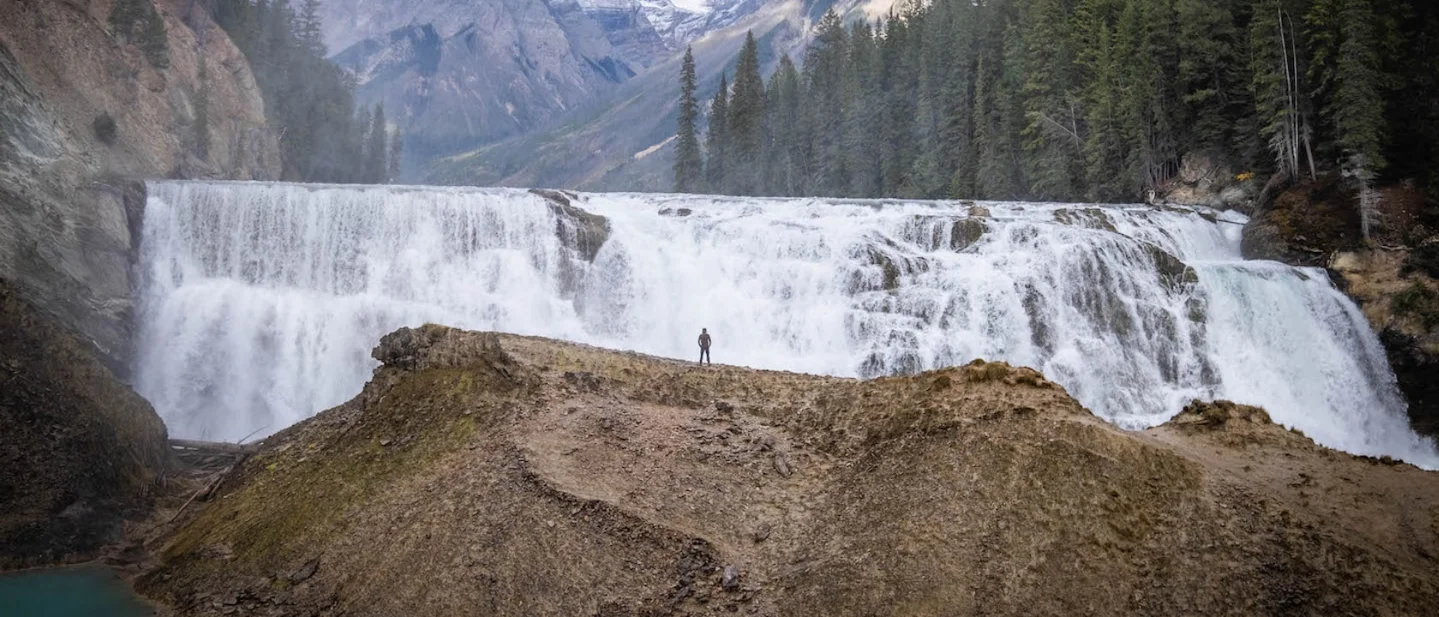
Wapta Falls is the cleanest option when you want a real destination without spending the whole day above treeline. The current route figures come from The Banff Blog: 4.6 km return, roughly 50–70 metres of gain, and one to three hours. The route is a short forest walk, with the final viewpoint opening onto a wide waterfall and mountain backdrop. 9
Parks Canada rated Wapta Falls Trail Good on Aug. 5. The same entry says there is deadfall, asks visitors to stay on designated trails and viewpoints, and notes no westbound access. The trail is therefore a go for hikers who want an easy route, but not a license to scramble around the river edge for a closer photograph. 2
Road, parking, and fees
Parks Canada’s Aug. 7 update lists Wapta Falls Road as open, with no westbound access. Its operating-hours page says the road, 24 km west of Field, is seasonal from the end of May through the end of October, weather permitting. The route guide describes the final approach as gravel and rough for smaller vehicles. 2910
No separate Wapta Falls parking fee appears on the current Parks Canada fee page. That page lists adult park admission at $12.25 per day, a family/group rate of $24.50, and a Discovery Pass at $83.50; youth 17 and under enter free. 11
Yoho’s current fire danger is Extreme, with a campfire ban dated July 30. That does not close Wapta Falls, but it changes the trip: do not plan a campfire stop, and check current wildfire notices before leaving. 2
Best plan: aim for Saturday or Sunday, confirm the westbound-access instruction and road condition, pay the park admission if you do not already hold a pass, and keep the group on the marked route. Wapta Falls is the pick for a strong payoff with the fewest physical and reservation demands.
The pick
Choose Lake Oesa if you already have the shuttle reservation and want the most concentrated alpine scenery. Choose Easy Pass if you want the hardest day and can start early enough to beat afternoon storms and smoke. Choose Wapta Falls if the group needs a shorter route that still feels like a destination.
Recheck the official trail, road, fire, and weather pages the morning you leave. This week’s hard gates are easy to name: Lake O’Hara’s reservation, Easy Pass’s storm-and-smoke window, and Wapta Falls Road’s direction and condition.
참고 출처
- 1Lake O’Hara trail descriptions — Parks Canadaparks.canada.ca
- 2Yoho trail conditions — Parks Canadaparks.canada.ca
- 3Yoho forecast — Environment Canadaweather.gc.ca
- 4Plan a trip to Lake O’Hara — Parks Canadaparks.canada.ca
- 5
- 6
- 7
- 8Cascades of Whatcom and Skagit Counties forecast — National Weather Serviceforecast.weather.gov
- 9How to Hike to Wapta Falls — The Banff Blogthebanffblog.com
- 10Hours of operation — Yoho National Parkparks.canada.ca
- 11Yoho fees — Parks Canadaparks.canada.ca
North American National Park & Hike Trail Pick
Weekly pick of 3 worth-going trails across US / Canadian national parks, state parks, and regional trails, with difficulty / season / parking info
이 콘텐츠는 채널이 자동으로 생성했습니다. 한 문장이면 Neodrop이 당신을 위해 계속 만들어 냅니다.
관련 콘텐츠
- 로그인하면 댓글을 작성할 수 있습니다.