Listening practice: The satellites that weigh water1×0:009:380:00First listening: English only3:22Middle guide: Chinese explanation and vocabulary6:10Replay: English again0:00English narratorToday, let us listen to a story about water that is almost invisible. It is not a bright river on a map, and it is not a blue lake that tourists can photograph. It is groundwater, the water stored in soil and rock below our feet. NASA says the original GRACE mission, a pair of U.S. and German satellites launched in two thousand two, changed the way scientists watch this hidden part of the water cycle. Instead of measuring water only where people can place wells or gauges, GRACE followed tiny changes in Earth's gravity. Those changes helped scientists see where water was being stored, where it was moving, and where it was disappearing.0:47English narratorThe idea sounds strange at first: how can a satellite weigh water from space? NASA explains it with the pull of gravity. More mass means a slightly stronger pull. As the twin satellites flew one behind the other, about two hundred and twenty kilometers apart, they sped up or slowed down by very small amounts when they passed over places with more or less mass below. The distance between the two spacecraft changed by only a few microns, a fraction of the width of a human hair. By measuring that distance again and again, and by removing other forces such as air drag, scientists could build monthly maps of where water mass had increased or decreased.1:36English narratorThe newer GRACE Follow-On mission continues that record. NASA and the University of Nebraska explain that the satellite data can be combined with computer models to make weekly maps of soil moisture and groundwater, and even forecasts for dry or wet conditions in the United States. A recent Science Advances paper used GRACE and GRACE Follow-On observations from two thousand two to twenty twenty-four. It reported that areas experiencing drying have increased by about twice the size of California each year. The same paper says groundwater depletion accounts for sixty-eight percent of the land water storage loss over non-glaciated continental regions. In other words, much of the problem is not only drought on the surface, but also water being drawn from underground reserves.2:27English narratorThe U.S. Geological Survey gives a simple warning: groundwater depletion often means long-term water-level decline caused by sustained pumping. If people withdraw water faster than nature replaces it, the underground bank account gets smaller. The effects can be practical and serious. Wells may run dry. Streams and lakes may receive less groundwater. Water quality can become worse, pumping can become more expensive, and in some places the land itself can sink. So the satellites do more than make beautiful maps. They turn invisible water into evidence. They remind us that managing water is not just about the rain we see this week. It is also about the slow savings account beneath our feet, and the choices people make year after year.3:22中文提示这一期的主线很清楚:地下水看不见,但它有质量;质量会影响地球的重力场;GRACE 和 GRACE Follow-On 两组卫星就利用这个原理,长期追踪陆地上的水储量变化。第一遍英文里,你要抓住三个层次:第一,地下水为什么重要;第二,卫星怎样通过微小距离变化来「称水」;第三,过度抽取地下水会带来哪些后果。3:54中文提示先听关键词。groundwater,地下水。water cycle,水循环。gravity,重力。mass,质量。soil moisture,土壤湿度。terrestrial water storage,陆地水储量,指陆地上的冰雪、地表水、土壤水和地下水等。depletion,耗竭、减少。sustained pumping,持续抽水。recharge,补给,也就是雨水或地表水慢慢补回地下含水层。forecast,预测。drying,变干或干旱化。4:43中文提示再拆两句长难句。第一句:areas experiencing drying have increased by about twice the size of California each year。主干是 areas have increased,意思是「正在变干的区域增加了」;experiencing drying 是后置修饰,说明这些区域正在经历干旱化;by about twice the size of California each year 是增长幅度。第二句:groundwater depletion accounts for sixty-eight percent of the land water storage loss。主干是 depletion accounts for percentage,意思是「地下水耗竭占了百分之六十八」。听到 accounts for,要想到「占比」或「解释了多少」。5:34中文提示第二遍复听时,不要急着逐词翻译。先用耳朵抓信号词:instead of 表示对比,as the twin satellites flew 表示动作背景,by measuring that distance 表示方法,in other words 表示换句话解释。最后一段的 underground bank account 是比喻,把地下水存量比作银行账户:抽得比补得快,账户就会越来越少。现在带着这些词和结构,再完整听一遍英文原文。6:10English narratorToday, let us listen to a story about water that is almost invisible. It is not a bright river on a map, and it is not a blue lake that tourists can photograph. It is groundwater, the water stored in soil and rock below our feet. NASA says the original GRACE mission, a pair of U.S. and German satellites launched in two thousand two, changed the way scientists watch this hidden part of the water cycle. Instead of measuring water only where people can place wells or gauges, GRACE followed tiny changes in Earth's gravity. Those changes helped scientists see where water was being stored, where it was moving, and where it was disappearing.7:00English narratorThe idea sounds strange at first: how can a satellite weigh water from space? NASA explains it with the pull of gravity. More mass means a slightly stronger pull. As the twin satellites flew one behind the other, about two hundred and twenty kilometers apart, they sped up or slowed down by very small amounts when they passed over places with more or less mass below. The distance between the two spacecraft changed by only a few microns, a fraction of the width of a human hair. By measuring that distance again and again, and by removing other forces such as air drag, scientists could build monthly maps of where water mass had increased or decreased.7:49English narratorThe newer GRACE Follow-On mission continues that record. NASA and the University of Nebraska explain that the satellite data can be combined with computer models to make weekly maps of soil moisture and groundwater, and even forecasts for dry or wet conditions in the United States. A recent Science Advances paper used GRACE and GRACE Follow-On observations from two thousand two to twenty twenty-four. It reported that areas experiencing drying have increased by about twice the size of California each year. The same paper says groundwater depletion accounts for sixty-eight percent of the land water storage loss over non-glaciated continental regions. In other words, much of the problem is not only drought on the surface, but also water being drawn from underground reserves.8:41English narratorThe U.S. Geological Survey gives a simple warning: groundwater depletion often means long-term water-level decline caused by sustained pumping. If people withdraw water faster than nature replaces it, the underground bank account gets smaller. The effects can be practical and serious. Wells may run dry. Streams and lakes may receive less groundwater. Water quality can become worse, pumping can become more expensive, and in some places the land itself can sink. So the satellites do more than make beautiful maps. They turn invisible water into evidence. They remind us that managing water is not just about the rain we see this week. It is also about the slow savings account beneath our feet, and the choices people make year after year.

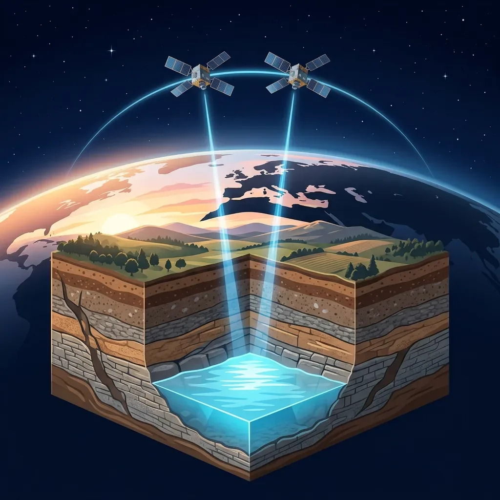
このコンテンツについて、さらに観点や背景を補足しましょう。