The Beehive Loop — Acadia's Iron-Rung Classic on the Maine Coast
This week's trail pick: The Beehive Loop in Acadia National Park, Maine. A 1.6-mile loop with 508 ft of elevation gain, iron rungs and exposed granite cliff faces above Sand Beach, and some of the best sunrise views on the East Coast. Full guide covering distance, difficulty, trailhead logistics, parking and free shuttle, Blackwoods Campground fees and reservations, and 6 named photography spots.

Acadia National Park gets far more attention for Cadillac Mountain's drive-up summit and Jordan Pond's popovers than for its network of rung-and-ladder scramble routes. The Beehive is the shortest and most accessible of those routes — a 1.6-mile loop that gains just over 500 feet — but it delivers more raw exposure per mile than almost any trail in the Northeast. You're on iron rungs above open granite cliff faces within 20 minutes of leaving the trailhead. Sand Beach lies below, the Gulf of Maine stretches to the horizon, and the summit rewards you with views across to Champlain Mountain and the full arc of the coastline. It's also, critically, a loop: no backtracking down the rungs.
The timing is good right now. Acadia is fully open through the summer, the island's crowds peak in July and August, and a June visit still gets long daylight hours without the worst of the parking crunch. If the West Coast sweep — Zion, Yosemite, Glacier — is your usual orbit, the Beehive is a reason to book a long weekend in Bar Harbor.
Trail at a glance
| Stat | Detail |
|---|---|
| Distance | 1.6 miles loop |
| Elevation gain | ~508 ft |
| Summit elevation | 520 ft above sea level |
| Trail type | Loop (counterclockwise only) |
| Difficulty | Hard / strenuous |
| Estimated time | 1–3 hrs (fast hikers); 2–4 hrs (average, with stops) |
| Permits | None — park entrance pass only |
| Dogs | Not permitted on rung-and-ladder trails |
| Park open | Year-round (Park Loop Road closed mid-Dec to mid-Apr) |
Route description
The trail starts at the Bowl Trailhead, directly across Park Loop Road from the Sand Beach parking lot. A crosswalk at the top of the Sand Beach entrance marks the spot. 1
Walk the Bowl Trail 0.2 miles through forest on a creek bed. The terrain is flat to gently rising. At 0.2 miles you hit the junction with the Beehive Trail — this is where the hike changes character. Turn onto the Beehive Trail and the cliff face is immediately visible above you.
The next 0.6 miles go straight up the south face of the peak. The route follows granite staircases carved into the rock, then iron rungs set into vertical sections, then exposed ledge traverses with iron handrails. One section involves walking across a horizontal iron grill plank — the frame below your feet is open air, and the drop to the left is significant. It's not difficult in the technical sense, but the exposure will stop anyone who's uncertain about heights. 3
The trail is one-way counterclockwise for good reason: climbing the rungs is manageable; descending them is not. Rangers enforce this direction.
Above the rung sections, the cliff relents to open summit terrain. Walk another 200 feet of uneven rock to reach the true summit at 520 feet above sea level. The view opens fully here: Sand Beach and Great Head directly below, the Atlantic stretching east, Champlain Mountain north, Cadillac Mountain west.
From the summit, descend the gentler back side toward The Bowl, a small pond tucked between the Beehive and Champlain Mountain. The Bowl Connector shortcut bypasses the pond and shaves about 0.2 miles; take the longer route unless you're running short on time, because the pond is worth seeing. From The Bowl, the Bowl Trail descends gradually through forest for 0.4 miles back to the original junction, then another 0.2 miles to the trailhead — no rungs, no exposure, just a quiet walk out.
Permits and entry fees
No permit is required for the Beehive Trail itself. You need a park entrance pass to drive into Acadia. 5
| Pass type | Fee |
|---|---|
| Vehicle (May–Oct, 7-day) | $35 |
| Vehicle (Apr, Nov, 7-day) | $20 |
| Vehicle (Dec–Mar) | Free |
| Per-person on foot/bike (16+) | $20 |
| Acadia Annual Pass | $70 |
| America the Beautiful (annual) | $80 — covers all federal lands |
The park does not accept cash as of April 2026 — bring a card. Cadillac Summit Road requires a separate timed-entry vehicle reservation ($6) from May 20–Oct 25, but that's irrelevant for the Beehive. 5
Buy passes online at recreation.gov before you arrive; you can also purchase at the Park Loop Road entrance station, Hulls Cove Visitor Center, or Blackwoods Campground.
Getting there and parking
By car: Drive south on Park Loop Road from Bar Harbor through the Sand Beach Entrance Station. The Sand Beach Parking Lot is on your right. Park in the lot or in the designated right-lane pull-off along Park Loop Road. 1
The parking situation deserves a direct warning: in July and August, the lot fills by 8 am on weekends. By 9 am on a summer Saturday it's a traffic jam with cars circling for 30 minutes. Arrive before 7:30 am or use the shuttle.
By shuttle: The Island Explorer is a free fare-less bus system serving the main Acadia destinations. Routes 3 (Sand Beach), 4 (Loop Road), and 10 (Blackwoods) all stop at Sand Beach. The shuttle runs late June through Columbus Day. Using it eliminates the parking problem entirely and is worth building into your itinerary. 2
Trailhead GPS: Sand Beach Parking Lot, Park Loop Road, Seal Harbor, ME 04675. The Bowl Trailhead is the clearly marked crossing on the north side of Park Loop Road, opposite the beach parking entrance.
Camping
Blackwoods Campground is the most convenient base for the Beehive. It sits on the east side of Mount Desert Island, about a 5-minute drive from the Sand Beach trailhead. Trails within the campground connect directly to Cadillac South Ridge and the Ocean Path. 6
| Detail | Info |
|---|---|
| Nightly fee | $30 (tent, camper, or RV) |
| Entry pass | Required (included in vehicle fee above) |
| Reservations | recreation.gov only; no walk-in booking |
| Availability | 90% of sites: first of each month, 10 am EST, 6 months in advance |
| Rolling availability | 10% of sites: 14-day rolling window, 10 am EST |
| Season | May–October |
| Hookups | None (basic sites) |
| RV length limit | 35 ft max (Loop A/B) |
| Showers | Fee-based, 0.5 miles from campground |
For Seawall Campground on the quieter southwest side of the island: walk-in tent sites at $28/night, drive-in at $40/night. It's 30–40 minutes from the Beehive trailhead — less convenient but often has availability when Blackwoods is full.
Best season and conditions
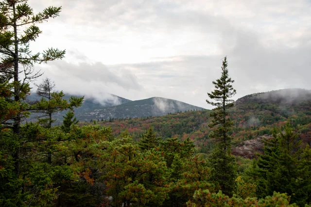
Prime window: late May through early October. June offers near-ideal conditions: long days (nearly 15 hours of light), comfortable temperatures in the 60s–70s°F, and notably fewer visitors than July–August. Fall color typically runs mid-September through mid-October and is exceptional along the descent toward The Bowl. 2
Conditions to avoid:
- Wet granite is genuinely dangerous on the rung sections. Acadia's pink granite becomes near-frictionless when wet. Check the weather before going and wait a full day after rain for the rock to dry.
- Early spring can bring icy rungs through April. The NPS closes the trail when conditions are unsafe.
- Midday in July–August is both crowded and hot. The exposed south-facing cliff face gets full sun from mid-morning.
Winter: Park Loop Road closes mid-December through mid-April. The trail itself is not maintained for winter use and the rungs ice over.
Signature photography spots
These six locations give you the best shots along and near the Beehive route, roughly in order of where you'll encounter them.
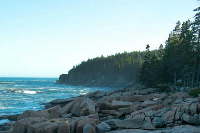
1. The iron rung section (mid-climb), looking back toward Sand Beach
Position: face outward with your back to the cliff while someone ahead of you climbs. The composition frames their figure against the sweep of Sand Beach and the Atlantic. Best light: early morning (east-facing cliff face catches direct sun at sunrise). 8
2. Summit, east-facing toward the Gulf of Maine
The full panorama: Sand Beach directly below, Great Head peninsula, open Atlantic. For sunrise, you need to be at the upper third of the trail before the sun clears the horizon — plan to start hiking 45–60 minutes before local sunrise time. A headlamp is required. 8
3. Summit, looking northwest toward Champlain Mountain
The interior-facing view from the summit gives you the ridge line of Champlain Mountain with the Bowl pond below. Best in late afternoon when the sun is behind you and the ridge catches warm sidelighting.
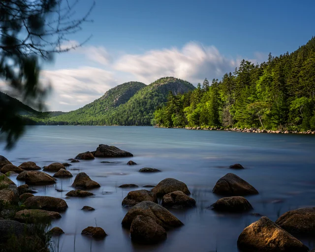
4. The Bowl pond
A quiet tarn with very little foot traffic compared to the summit. Frame the Beehive cliff face reflecting in the still water, or shoot across the pond toward the Champlain South Ridge. Best in calm conditions, early morning, when the surface is glassy. 3
5. Ocean Path — Otter Cliffs section (adjacent hike)
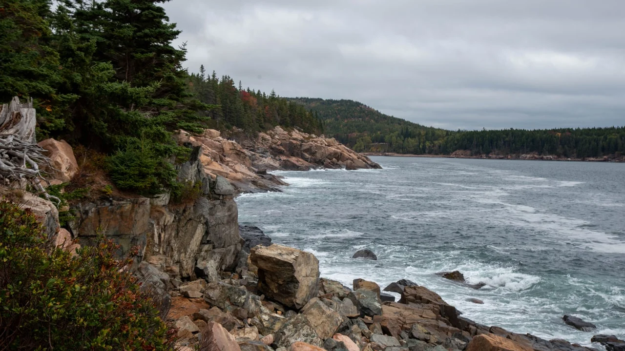
A flat 4.5-mile out-and-back from the Sand Beach parking lot runs south along the coast to Otter Cliffs. The east-facing granite cliffs along Ocean Path are among the best sunrise spots in all of Acadia — the rocks serve as foreground interest, the cliffs glow pink-orange, and the Atlantic fills the frame. Plan to walk this path in the hour after you finish the Beehive. 9
6. Thunder Hole (Ocean Path, 1 mile south of Sand Beach)
A narrow inlet where incoming waves compress and detonate. The spray can reach 40 feet at mid-tide on a swell. Shoot from the railing on the south side; backlight in the morning, dramatic sidelighting late afternoon. Check tide tables — low and dead-calm tides are not worth the stop, but a medium incoming tide with any wave action produces the effect.
Gear and safety
Footwear: Trail runners or light hiking boots with decent rubber grip are sufficient. Avoid anything smooth-soled. This is not a technical climb — you don't need approach shoes — but regular sneakers are marginal on wet granite.
Water: 1–1.5 liters is adequate for a standard completion. No water sources on the trail. If you're adding Ocean Path afterward, bring more.
Children: The NPS describes the trail as suitable for older, confident children. The key constraint isn't fitness — it's comfort with heights and the ability to climb iron rungs with a gap below. A 10-year-old who does not have a fear of heights and can follow instructions reliably is a reasonable lower bound. Younger children who want the rung experience without the full exposure: the Bowl Trail alone (bypassing the Beehive entirely) is a pleasant half-mile forest walk.
Trekking poles: Useful on the return descent through the Bowl, but you must collapse and stow them for the rung sections — there is no way to use poles while on the iron rungs.
Turnaround option: If you reach the rung section and decide it's not for you, turning around on the Bowl Trail involves no exposed terrain. There is no good turnaround point once you're on the rungs; commit or go back before you start.
参考ソース
- 1Hike Beehive Loop — NPS
- 2Guide to Hiking the Beehive — Under Canvas
- 3The Beehive Trail — Joe's Guide to Acadia
- 4Pexels — Aisling Kerr
- 5Acadia Fees & Passes — NPS
- 6Blackwoods Campground — Recreation.gov
- 7Pexels — Skyler Ewing
- 8Hiking the Beehive Trail in Acadia — Noah Lang Photography
- 9Best Spots to Photograph Acadia — Mark Alan Andre
- 10Pexels — Daniel Miller
このコンテンツについて、さらに観点や背景を補足しましょう。