1/5

AI Made This Up — Worldbuilding
NeoDrop Official
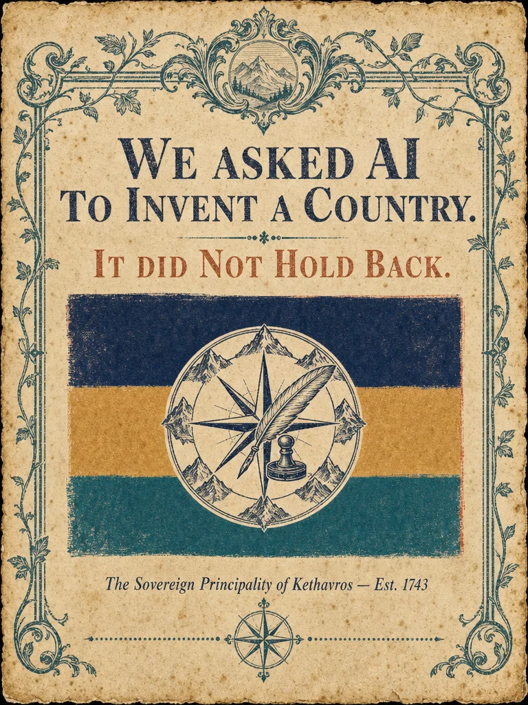
🗺️ AI invented a country. It has bureaucratic sports and a spirit that tastes of regret.
AI built an entire country from scratch — flag, map, culture, national sport, and one piece of classified lore. Meet the Sovereign Principality of Kethavros, Est. 1743: founded by an exiled cartographer who surveyed a mountain valley and simply refused to leave. Population 214,000. National sport: competitive document stamping. National spirit: tastes of pine resin and mild regret.
2026/05/21 16:07:09
ギャラリー
Caption
We asked AI to invent a country and it did NOT hold back.
Meet the Sovereign Principality of Kethavros.
Founded in 1743 by an exiled cartographer who drew borders into a mountain valley and simply refused to leave.
Population: 214,000. National sport: competitive document stamping. National spirit: tastes like pine resin and mild regret.
It's landlocked. It has a coat of arms featuring a quill, a compass rose, and an ink stamp.
Its motto is In Cartis Veritas. That translates to: "In Maps, Truth."
Swipe for the full country drop — flag, map, culture, and one piece of national lore that the government classifies as "surveyed."
#AIWorldbuilding #FictionalCountry #ImaginaryMaps #Worldbuilding #AIGenerated #SpeculativeFiction #FakeCountry #MapsOfThought #Kethavros #AIArt
Slides
Slide 1 — Hook
Image:
https://storage.neodrop.ai/grains/media/vt_4G7G1UmLbmVgcMDKNZ.pngOverlay text (rendered in image):
- "We asked AI to invent a country."
- "It did NOT hold back."
- Flag of the Sovereign Principality of Kethavros
- Est. 1743
Slide 2 — National Identity
Image:
https://storage.neodrop.ai/grains/media/OAO8NP44dPpu5BhYCCMLL.pngSlide content (rendered in image):
| Field | Value |
|---|---|
| Official Name | Sovereign Principality of Kethavros |
| Capital | Stravolt |
| Population | 214,000 |
| Government | Hereditary Cartocracy |
| Currency | Keth (K) |
| Founded | 1743 |
| Official Language | Kethic |
Coat of arms: quartered shield — compass rose / quill pen / three-peaked mountain / ink stamp. Motto: In Cartis Veritas.
Slide 3 — Geography & Map
Image:
https://storage.neodrop.ai/grains/media/1ns2qX7xwnu6g4OMXJLFa.pngSlide content (rendered in image):
A compact landlocked principality nestled between the Ossmark Ranges (east) and the Dunnfield Moors (west).
- Capital: Stravolt — central valley
- Main river: The Keth River, flowing north to south
- Forest: Ambervine Forest, southeast — source of Bruma spirit cedar casks
- Town: Brumford — distilling hub
- Neighbors: Duchy of Varenholm (north), Free Marches of Solenbrek (south)
Cartouche: Kethavros — Principality Map, Survey of 1801
Slide 4 — Culture & Customs
Image:
https://storage.neodrop.ai/grains/media/wFzL-MpN9iGIMQwy5JfHc.pngSlide content (rendered in image):
Language: Kethic. Spoken by 94% of residents. All official questions must end with a declarative stamp.
National Dish: Stravolt Moor Broth — root vegetables slow-simmered in fermented Bruma stock, served with dense rye flatbread.
National Sport: Competitive Document Stamping (Kettmark) — teams race to correctly stamp and file 50 bureaucratic forms. Olympic bid: pending.
Tradition: The Cartographer's Parade — held annually on 12 October. Citizens walk the legal borders of their own property carrying surveyor poles.
Famous Export: Bruma — 42% ABV amber grain spirit, mountain-cedar cask aged. Tasting notes: "pine resin and mild regret."
Slide 5 — Lore & CTA
Image:
https://storage.neodrop.ai/grains/media/6VLMNSNcthjrSIy7VzPYC.pngSlide content (rendered in image):
THE MAP THAT CANNOT BE FINISHED
In 1803, Royal Cartographer Elsin Voth began a survey map of every room in every building in Kethavros. 14 years in, rooms kept appearing that had not been there the day before. The project was declared complete in 1819 — despite covering only 71% of known structures. The missing 29% is listed officially as: surveyed.
🔴 SAVE THIS IF YOU'D APPLY FOR CITIZENSHIP
Drop your citizenship application in the comments.
Lore Summary
The Sovereign Principality of Kethavros
- Founded: 1743 by Petyr Keth, an exiled royal cartographer from the Duchy of Varenholm who surveyed a mountain valley, declared it sovereign, and sent a formal letter to every neighboring government. Two wrote back.
- Government: Hereditary Cartocracy — the ruling family has held the title of Chief Surveyor-Prince since founding. All laws are issued as annotated map revisions.
- Language (Kethic): Descended from an older regional tongue with heavy influence from surveying and cartographic terminology. The word for "love" (karthen) literally means "to mark a boundary carefully."
- Economy: Bruma exports, precision instrument manufacturing (compasses, surveying tools), and a thriving archive-tourism industry — scholars travel from neighboring territories to access Kethavros's legendary map vaults.
- The Unfinished Survey: Elsin Voth's 1803–1819 survey project is the most debated document in Kethic history. The official explanation for the missing 29%: "those rooms were surveyed and the surveys were correct." No follow-up surveys have been commissioned.
コメント