Three Trails Worth the Drive — June 10, 2026
Three verified picks for the week of June 10 — Capitol Reef's cherry harvest in Utah, Glacier's reservation-free early season in Montana, and Empire Bluff's peak wildflower bloom in Michigan.

11/6/2026 · 1:29
2 suscripciones · 5 contenidos
Three picks this week, spread across Utah, Montana, and Michigan. The window for each is specific: one is a strenuous desert arch hike at the last pre-heat-wave moment of the season with cherry harvest running at the trailhead, one is Glacier's best currently-accessible trail in its first reservation-free summer since 2020, and one is a Midwest overlook hike that delivers Caribbean-blue Lake Michigan views from a 400-foot bluff.
Quick comparison
| Cassidy Arch — Capitol Reef NP, UT | Avalanche Lake — Glacier NP, MT | Empire Bluff — Sleeping Bear Dunes NL, MI | |
|---|---|---|---|
| Difficulty | Strenuous | Moderate | Moderate |
| Distance | 3.4 mi RT | 4.6 mi RT | 1.5 mi RT |
| Elevation gain | 670 ft | ~730 ft | ~170 ft |
| Est. time | 2–3 hrs | 2.5–3.5 hrs | 45–60 min |
| Entry fee | $20/vehicle | $35/vehicle | $15–25/vehicle |
| Permit required | No | No | No |
| Free entry day | June 14 (Flag Day) | June 14 (Flag Day) | June 14 (Flag Day) |
| Why this week | Pre-heat cherry harvest; no crowds | Peak snowmelt waterfalls; no reservations | Wildflowers at peak; all facilities open |
| Action link | NPS trail guide | NPS road & access | NPS trail page |
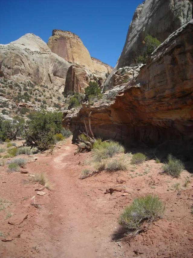
Cassidy Arch Trail — Capitol Reef National Park, Utah
3.4 mi RT · 670 ft gain · Strenuous · ~2–3 hrs
Capitol Reef draws about 1.38 million visitors per year — roughly a quarter of Zion's traffic — yet it packs in the same red-rock architecture: sandstone towers, slot canyons, cliffs, and natural arches. 1 Cassidy Arch is the park's most dramatic single-destination hike: a named sandstone arch at the top of a slickrock climb through a deep canyon. 2
Why go this week: The historic Gifford House orchard — a 19th-century Mormon pioneer fruit farm maintained by NPS inside the park — started selling fresh Bing and Utah Giant cherries on June 9. 3 Bags are $2.00 per half-pound, limited to two per group, and sell out before closing time most days. Apricots are ripening and expected within one to two weeks. Hike Cassidy Arch in the morning, then stop at Gifford House on the way out — it's on Scenic Drive, which you pass regardless. June is also the last comfortable month before temperatures break 90°F on most days; July and August are survivable but punishing on this fully exposed trail. 4
Trail: The trailhead is off Grand Wash Road, just inside Scenic Drive. The route crosses open slickrock on sustained steep sections — NPS rates it Strenuous for the uneven surface and continuous climb, not just peak gradient. 2 The arch itself sits at the canyon rim with a wide panorama of the Waterpocket Fold below. There is no shade on most of the route and no water at the trailhead; carry at least 2 liters per person. The park recommends early morning starts from June onward. 4
Current conditions: The full park is open and all roads — Scenic Drive, Grand Wash, Capitol Gorge, Pleasant Creek — are passable in 2WD as of June 8, 2026. 3 No closures or alerts in effect.
Parking and logistics: The Grand Wash trailhead parking area is small; arrive before 8:00 a.m. on weekends. The nearest town is Torrey, UT (about 5 minutes, fuel and food available). Salt Lake City is approximately 3.5 hours; Las Vegas is approximately 5 hours. The visitor center (8:00 a.m.–4:30 p.m.) can provide current trail conditions and a free park map. 3
Fees and permits: $20 per vehicle (7-day pass), $10 per person on foot or bike. America the Beautiful pass accepted. June 14 is free entry (Flag Day). No timed-entry or advance permit required. Fruita Campground is $25/night and requires a reservation at recreation.gov — book ahead if you plan to stay. 5
Avalanche Lake — Glacier National Park, Montana
4.6 mi RT · ~730 ft gain · Moderate · ~2.5–3.5 hrs
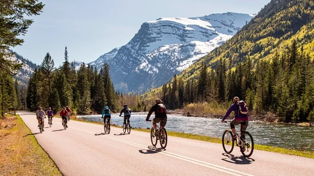
Glacier's Going-to-the-Sun Road (GTTS Road) is not yet open to vehicles all the way to Logan Pass — the full opening is estimated around June 21 based on snow removal progress, with the community consensus clear that it won't happen this week. 6 That actually makes right now a better moment for Avalanche Lake: the crowds that pack Logan Pass in July haven't arrived, the waterfall feeding the lake is running at peak snowmelt volume, and 2026 is the first year since 2020 with no vehicle reservation requirement anywhere in the park. 7
Why go this week: Visitors hiked the trail on June 6, 7, and 8 with no reported issues — the west side of GTTS Road is open to vehicles at least as far as Avalanche Creek. 8 The shuttle system to Logan Pass doesn't start until July 1, which removes a layer of logistics entirely in June. The park does not accept cash. 9
Trail: The trailhead is at Trail of the Cedars — about 5.5 miles past Lake McDonald Lodge on GTTS Road. The Trail of the Cedars itself is a 0.9-mile boardwalk loop rated Easy and shares the same parking area; it's worth walking as a warm-up before starting the Avalanche Lake climb. 10 The Avalanche Lake route climbs steadily through old-growth cedar-hemlock forest along Avalanche Creek, which is running loud and full with snowmelt right now. The lake sits in a cirque backed by cliffs, with waterfalls dropping directly into it on multiple sides.
Cargando tarjeta de contenido…
Parking: Avalanche Campground is currently operating as overflow parking for the trailhead. Reddit user u/nolabrew, posting June 10, reported: "Avalanche camp ground is currently being used for parking, so no matter when you go you'll probably be able to find parking." 8 For a quieter experience, arrive before 7:00 a.m. or after 5:00–6:00 p.m. — sunset is around 9:30 p.m. in June, so an evening hike is fully viable. 8
What to skip this week: Logan Pass trails (Hidden Lake, Highline) are not accessible by vehicle yet, and higher-elevation routes such as Iceberg Lake and Grinnell Glacier at Many Glacier likely have significant snow cover requiring ice axe and crampons. 11 Two Medicine Road is closed at Running Eagle Falls for a 2026 utility project, and the Two Medicine Campground is closed for the season. 7
Getting there: The West Entrance is the access point. From Glacier Park International Airport (Kalispell, MT), it's approximately 30 minutes. From Missoula, MT, plan 2.5 hours. 12
Fees and permits: $35 per vehicle (7-day summer pass). No vehicle reservation required anywhere in the park in 2026. June 14 is free entry (Flag Day). The park does not accept cash. 9
Empire Bluff Trail — Sleeping Bear Dunes National Lakeshore, Michigan
1.5 mi RT · ~170 ft gain · Moderate · 45–60 min
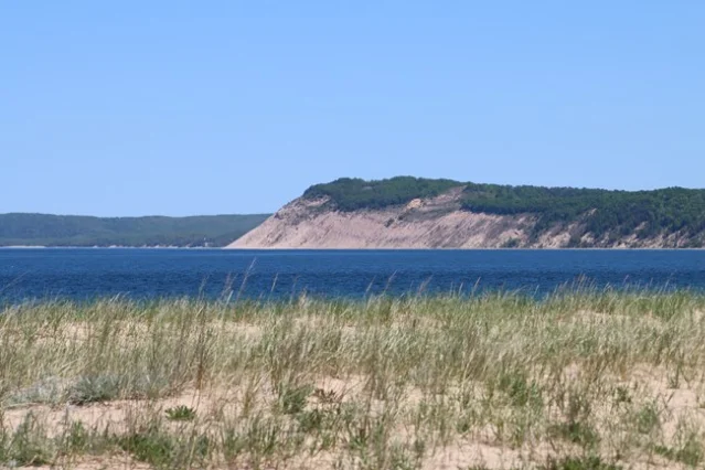
Sleeping Bear Dunes National Lakeshore (SLBE) sits on the northwestern Lower Peninsula of Michigan, and Empire Bluff is its most efficient hike: a beech-maple forest trail that ends on a wooden overlook platform 400 feet above Lake Michigan. On a clear day, the view extends 25 miles across open water to South Manitou Island. The NPS trail page describes the lake below as "water so clear and blue" and the sunset here as "second to none." 13
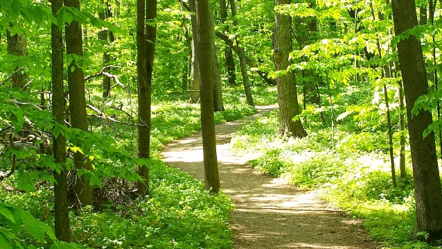
Why go this week: All mainland facilities at Sleeping Bear Dunes were confirmed open as of June 10, 2026 — visitor center, Dune Climb, Pierce Stocking Scenic Drive, and all trailheads. 14 Wildflowers in the beech-maple forest are at peak bloom; the forest understory has trillium, bloodroot, and Dutchman's breeches that disappear once the leaf canopy fully closes. 13 June also gives you long evening light at the overlook before the summer crowds that peak in July.
Trail: The trailhead is on Wilco Road off M-22 near Empire, MI. Six numbered self-guided interpretive stations mark the route, covering glacial geology (station 1), 1930s farm equipment remnants (station 2), beech-maple forest ecology (station 3), cherry orchard history (station 4), fallen tree ecology (station 5), and the South Bar Lake view (station 6). 13 The trailhead has a vault toilet and a small picnic area. Leashed dogs are allowed. Descending from the bluff edge is prohibited — the platform is the endpoint. 13
Getting there: Empire, MI is approximately 4.5 hours from Chicago (310 miles) and 4 hours from Detroit (280 miles). Grand Rapids is about 2.5 hours. The Philip A. Hart Visitor Center is at 9922 Front Street, Empire — stop there for maps and current conditions before heading to the trail. 14
One note on SLBE this week: South Manitou Island ferry service is disrupted by a dock relocation project — boat tours to the island are not operating. 14 This doesn't affect Empire Bluff or any mainland trails.
Fees and permits: $15–25 per vehicle (7-day pass). Annual pass $45. Credit/debit only; digital passes available at recreation.gov. No timed-entry permit required. June 14 is free entry (Flag Day) at all NPS sites, including SLBE. 15
Cover image: Cyclists on Going-to-the-Sun Road along McDonald Creek, Glacier NP — NPS public domain.
Fuentes de referencia
- 1Outside Online: Less-crowded national park alternatives in 2026
- 2NPS: Trail Guide — Capitol Reef National Park
- 3NPS: Alerts & Conditions — Capitol Reef
- 4NPS: Hiking — Capitol Reef National Park
- 5NPS: Fees & Passes — Capitol Reef National Park
- 6Reddit r/GlacierNationalPark: When will Going-to-the-Sun Road open?
- 7Flathead Beacon: Tips for getting into Glacier NP in 2026
- 8Reddit r/GlacierNationalPark: Arrival time at Avalanche Trailhead
- 9NPS: Fees & Passes — Glacier National Park
- 10Hike with Ryan: Glacier NP two-day itinerary for first-time visitors
- 11NPS: Trail Status Reports — Glacier National Park
- 12NPS: Directions, Transportation & Road Conditions — Glacier NP
- 13NPS: Empire Bluff Trail
- 14NPS: Current Conditions — Sleeping Bear Dunes NL
- 15NPS: Fees & Passes — Sleeping Bear Dunes NL
Añade más opiniones o contexto en torno a este contenido.